It looks like we're about to shift gears...
August has started HOT with daytime highs of:
25 - Aug 1
27 - Aug 2
30 - Aug 3
That continues the trend we had in July.
July 2015 ended up with an average high of 25.5 degrees.
That's more than 2 degrees hotter than the 30-year average of 23.1 It was the hottest July since 2007, when we had an average high of 26.6
However...we're in for a bit of a cooldown this week.
Daytime highs will drop to the 20 range instead of the mid to high 20s.
Edmonton & area gets back to the mid to high 20s by the weekend & the long-range forecast for next week looks hot.
But...this week will be cloudier & cooler.
Some heavier rain has been sliding past the Capital Region this morning.
Areas south, east & northwest of Edmonton have had showers & thunderstorms through the early morning hours.
However...most of that has missed the Capital Region.
There's still a chance of a shower or two hitting the area later this morning or early this afternoon.
But, MOST of the Capital Region will just be cloudy for MOST of today.
Elsewhere...
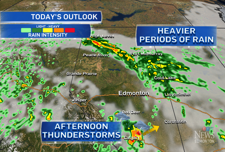
Heavy rain (maybe as much as 20-40mm) is possible in parts of east-central & NE Alberta today, tonight & tomorrow.
Areas between Red Deer & Calgary have a risk of thunderstorms (possibly severe) later today.
5-10mm of rain hit Grande Prairie overnight. That rain is still falling E & N of Grande Prairie & will track NE through the day.
Here's the Edmonton forecast:
Today - Cloudy. 30% chance of a scattered shower this morning or early this afternoon.
High: 23
Tonight - Cloudy periods.
Low: 12
Wednesday - Partly cloudy in the morning. Increasing afternoon cloud.
40% chance of a shower or thunderstorm in the afternoon/evening.
High: 21
Thursday - Mostly cloudy. 60% chance of showers.
Morning Low: 12
Afternoon High: 20
Friday - Partly cloudy.
Morning Low: 10
Afternoon High: 24
Saturday - Mainly sunny.
Morning Low: 13
Afternoon High: 26
Sunday - Partly cloudy.
Morning Low: 14
Afternoon High: 26
Advertisement
Cooler & Cloudier - August 4, 2015
CTV Edmonton
Published Tuesday, August 4, 2015 8:12AM MDT
Published Tuesday, August 4, 2015 8:12AM MDT
