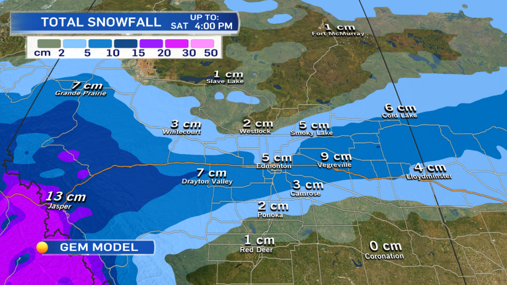
NOTE: The snow totals on the attached map are estimates.
I'm not completely buying ALL of those totals, but...more on that in a moment.
Snowfall WARNINGs are in effect for Jasper, Banff, Hinton/Grande Cache and Whitecourt/Edson areas.
10-20cm is possible at higher elevations in the mountains while Jasper townsite is expecting 5-10cm.
In the Hinton/Grande Cache & Whitecourt/Edson regions - 10-15cm of snow is possible.
I think the Grande Cache region could get close to 10cm.
But, the Whitecourt area probably gets closer to 5-10cm.
Hinton/Edson have a better chance at getting 15cm.
(so...i think the GEM model on the attached map is underestimating the Whitecourt snow & it's probably overestimating the Grande Prairie snow.)
What about the Edmonton area:
If you watched CTV News last night at 6pm, I mentioned there would be a snow-zone of 2-6cm that would stretch across part of Central/North-Central Alberta.
AND...we figured that location of that zone was uncertain.
So, I had 1-5cm as a snow estimate for Edmonton & area.
The location of that zone late yesterday was projected to be between Edmonton & Calgary
Well, this morning...that zone has shifted north (and it's still not set in stone.)
POSSIBLE snowfall totals for the Capital Region range from 0-10cm of snow.
BUT - I still think 10cm is unlikely for most of the area & 1-5cm is much more likely (with most of that snow falling between 2am & 8am Saturday).
Stay tuned... I'll send out another update on the CTV Edmonton weather app, on social media & on TV later today.
Let's talk temperatures:
We were above 0 in Edmonton Thursday and we'll be even warmer in the city today.
Our high near 5c should come early in the afternoon.
By late-afternoon or early this evening, the wind will likely swing around to the north as the cold front
Daytime highs will drop dramatically behind that cold front.
Temperatures fall from the -10 range Saturday morning to about -15 Saturday afternoon.
Sunday should be around -10 as well AND it appears the colder air will stick around into at least the first half of next week.
Here's the Edmonton forecast:
Today - Partly cloudy this morning. Increasing afternoon cloud. 30% chance of late-afternoon flurries.
High: 4
Tonight - Cloudy with periods of snow overnight.
Evening: -3
Saturday - 70% chance of snow in the morning. 1-5cm possible by midday Saturday.
Mostly cloudy Saturday afternoon. Temperature falling.
Morning: -10
Afternoon: -14
Sunday - Mix of sun & cloud.
Morning Low: -18
Afternoon High: -11
Monday - Mostly cloudy.
Morning Low: -16
Afternoon High: -10
Tuesday - Partly cloudy.
Morning Low: -18
Afternoon High: -10
Wednesday - Mostly cloudy.
Morning Low: -18
Afternoon High: -11
Advertisement
WARM TODAY : SNOW TONIGHT/SATURDAY - March 3
CTV Edmonton
Published Friday, March 3, 2017 7:39AM MST
Published Friday, March 3, 2017 7:39AM MST
