Josh Classen's forecast: From spring-like to wintry in 24 hours

Clouds and even a few more showers in parts of the Edmonton region early this morning.
At 6 a.m., areas from Legal southeast through Fort Saskatchewan and down towards Tofield were getting some light rain.
Thankfully, temperatres are WELL above 0 C this morning so most roads are just wet. However...any driveways, parking lots, side streets etc that had some snow or ice on them prior to last night and this morning's rain are going to be fairly slippery this morning.
Wind started to gust early this morning and should remain gusty all day.
Temperatures will waver between 5 and 7 C through the morning and early afternoon hours. We'll probably start to see some cooling by suppertime.
More cooling tomorrow as temperatures tumble through the day. Edmonton falls from temperatures near zero in the morning, to the -10 C range by late afternoon.
AND...we'll have some breezy conditions Friday. Not as windy as today, but enough to kick in a wind chill near -20 C later in the afternoon.
Cold air settles in for the weekend with mornings near -20 C and afternoons in the mid minus teens.
BUT...it's still looking like we'll see some milder conditions move in for at least parts of next week.
More on that in a moment...
As for snow: We'll see some move through the Edmonton region tonight and then a few flurries or pockets of light snow Friday (especially early in the day).
Most of the Edmonton region probably gets 2 to 4 cm. Some spots could get closer to 8 cm, especially to the southwest of the city.
We'll have some heavy snow in the mountains parks with 10-20 cm generally and some spots picking up even more.
Red Deer and area probably wind up with 3 to 7 cm, but areas not too far to the west and southwest could get closer to 10+ cm.
Calgary should pick up 5 to 10 cm with localized pockets of higher amounts.
There will be parts of Highway 16 west to Jasper that get hit with some heavier snow (10+ cm), particularly from around Edson west toward Jasper.
Grande Cache and area will get significant snow, probably in the 10-20 cm range.
Grande Praire is on the northern edge of that heavier snow and probably ends up with 3 to 7 cm.
Areas east and northeast of Edmonton will get some light snow and flurries, with most of east-central Alberta getting 1 to 4 cm.
Northeast Alberta gets minimal accumulation.
OK...back to the milder trend for next week.
It looks like the arctic air that drops in this weekend will shift off to the east fairly quickly.
We'll still be a lot cooler than the temperatures we had this week.
But...probably not much worse than slightly below average. Daytime highs will likely be in the -5 C to -10 C range for Monday-Wednesday, and then closer to the freezing mark towards the end of next week.
Here's the forecast for Edmonton and area:
Today - Cloudy with a few sunny breaks. Windy.
Wind NW 20-30 km/h with gusts in the 40 to 50 km/h range.
Temperature steady in the 5 to 7 degree range through the morning and early afternoon.
Tonight - Cloudy. A few flurries and pockets of light snow.
Wind easing late this evening.
9pm: 1
Friday - Mostly cloudy with occasional flurries and pockets of light snow. Breezy.
Total accumulation in the 2 to 8 cm range (including Thursday night's precip)
Wind: N 15-20 km/h - wind chills in the -15 to -20 range in the afternoon.
Temperature falling through the day.
Morning: -2
Afternoon: -10
Saturday - Mix of sun & cloud. 30% chance of flurries.
Morning Low: -20
Afternoon High: -15
Sunday - Mix of sun & cloud.
Morning Low: -20
Afternoon High: -16
Monday - Mostly cloudy.
Morning Low: -19
Afternoon High: -9
Tuesday - Cloudy. 30% chance of flurries/light snow.
Morning Low: -15
Afternoon High: -7


CTVNews.ca Top Stories

Young people 'tortured' if stolen vehicle operations fail, Montreal police tell MPs
One day after a Montreal police officer fired gunshots at a suspect in a stolen vehicle, senior officers were telling parliamentarians that organized crime groups are recruiting people as young as 15 in the city to steal cars so that they can be shipped overseas.
Man sets self on fire outside New York court where Trump trial underway
A man set himself on fire on Friday outside the New York courthouse where Donald Trump's historic hush-money trial was taking place as jury selection wrapped up, but officials said he did not appear to have been targeting Trump.
Sask. father found guilty of withholding daughter to prevent her from getting COVID-19 vaccine
Michael Gordon Jackson, a Saskatchewan man accused of abducting his daughter to prevent her from getting a COVID-19 vaccine, has been found guilty for contravention of a custody order.
Mandisa, Grammy award-winning 'American Idol' alum, dead at 47
Soulful gospel artist Mandisa, a Grammy-winning singer who got her start as a contestant on 'American Idol' in 2006, has died, according to a statement on her verified social media. She was 47.
She set out to find a husband in a year. Then she matched with a guy on a dating app on the other side of the world
Scottish comedian Samantha Hannah was working on a comedy show about finding a husband when Toby Hunter came into her life. What happened next surprised them both.
'It was joy': Trapped B.C. orca calf eats seal meat, putting rescue on hold
A rescue operation for an orca calf trapped in a remote tidal lagoon off Vancouver Island has been put on hold after it started eating seal meat thrown in the water for what is believed to be the first time.
B.C. judge orders shared dog custody for exes who both 'clearly love Stella'
In a first-of-its-kind ruling, a B.C. judge has awarded a former couple joint custody of their dog.
Shivering for health: The myths and truths of ice baths explained
In a climate of social media-endorsed wellness rituals, plunging into cold water has promised to aid muscle recovery, enhance mental health and support immune system function. But the evidence of such benefits sits on thin ice, according to researchers.
'It could be catastrophic': Woman says natural supplement contained hidden painkiller drug
A Manitoba woman thought she found a miracle natural supplement, but said a hidden ingredient wreaked havoc on her health.
Shopping Trends
The Shopping Trends team is independent of the journalists at CTV News. We may earn a commission when you use our links to shop. Read about us.


Calgary
-
From 'barely surviving, to living': Calgary family champions local mental health supports
It seemed like their world was crashing in when free mental health services changed the lives of a Calgary family and now they are trying to help others get the same support.
-
B-Boy and B-Girls descend on Calgary for Red Bull BC One qualifying event
A pair of Calgary dancers are among the B-Boys and B-Girls in town to compete in a Red Bull BC one qualifying event Saturday night.
-
Calgary man accused in toddler death released on bail
Winston Campbell granted bail at first court appearance
Lethbridge
-
Lethbridge cutting back on water use as part of provincial water sharing agreement
The province has announced the largest water sharing agreement in Alberta’s history, which will see Lethbridge and Medicine Hat, among other municipalities, cut water use.
-
Medicine Hat woman charged after $60K stolen from Redcliff Legion
Mounties say a 32-year-old Medicine Hat woman has been charged in connection with the theft of $60,000 from the Redcliff Legion.
-
Deterrent sentence possible, expert says, after trio convicted in connection to Coutts border blockade
Three men who helped lead and co-ordinate the 2022 border blockade at Coutts, Alta., have been found guilty of public mischief.
Saskatoon
-

‘My family are all broken-hearted’: Grandfather of homicide victim speaks out
Saskatoon is grappling with the tragic death of 24-year-old Melissa Duquette, whose body was discovered on April 15. A day later, authorities confirmed her death as a homicide, sparking deep sorrow and calls for action within the community.
-
Saskatoon judge to make ruling on evidence in fatal THC-impaired driving case
A Saskatoon Provincial Court judge will determine whether testimony from a woman, charged with impaired driving causing the death of a child, will be used as evidence in her trial.
-
Sask. Teachers' Federation sending offer to a vote 'tactical move': labour scholar
Teachers have three weeks to consider how they’ll vote on an offer from the provincial bargaining committee. But where does the dispute go next?
Regina
-

Sask. father found guilty of withholding daughter to prevent her from getting COVID-19 vaccine
Michael Gordon Jackson, a Saskatchewan man accused of abducting his daughter to prevent her from getting a COVID-19 vaccine, has been found guilty for contravention of a custody order.
-
Sask. Teachers' Federation sending offer to a vote 'tactical move': labour scholar
Teachers have three weeks to consider how they’ll vote on an offer from the provincial bargaining committee. But where does the dispute go next?
-
Saskatoon police to search landfill for remains of woman missing since 2020
Saskatoon police say they will begin searching the city’s landfill for the remains of Mackenzie Lee Trottier, who has been missing for more than three years.
Vancouver
-

B.C. judge orders shared dog custody for exes who both 'clearly love Stella'
In a first-of-its-kind ruling, a B.C. judge has awarded a former couple joint custody of their dog.
-
Home sale contract handwritten in Chinese holds up in B.C. court
A one-page contract for the purchase of a B.C. home that was handwritten in Chinese has been deemed valid in the province's Supreme Court, leaving the would-be buyer on the hook for more than $400,000.
-
B.C. student among hundreds of false winners of Tim Hortons contest
Since moving to B.C. from Colombia to go to university, Marylin Moreno has been a regular at Tim Hortons – and she always scans her app so she can play the iconic Roll Up To Win contest.
Vancouver Island
-

'It was joy': Trapped B.C. orca calf eats seal meat, putting rescue on hold
A rescue operation for an orca calf trapped in a remote tidal lagoon off Vancouver Island has been put on hold after it started eating seal meat thrown in the water for what is believed to be the first time.
-
After breaking world records and training movie stars, B.C. free diver becomes police dispatcher
For as long as Mandy-Rae Krack can recall, the water has inspired wonder.
-
Mounties arrest 7 after 'significant' seizure of drugs, guns on Vancouver Island
Mounties say seven people have been arrested after a series of co-ordinated property searches on Vancouver Island yielded multiple firearms, including 3D-printed handguns, and several kilograms of drugs.
Toronto
-

Ontario early childhood educators still waiting for promised 2024 wage increases
Ontario Registered Early Childhood Educators (RECEs) are still waiting for their promised 2024 wage increases and advocates say the delay is causing stress for workers.
-
U.S. FAA launches investigation into unauthorized personnel in cockpit of Colorado Rockies flight to Toronto
The U.S.’s Federal Aviation Administration is investigating a video that appears to show unauthorized personnel in the cockpit of a charted Colorado Rockies flight to Toronto.
-
WATCH
WATCH Video shows dramatic police takedown of carjacking suspects chased through parking lot north of Toronto
Police have released video footage of a dramatic takedown of a group of teens wanted in connection with an attempted carjacking in Markham earlier this month.
Montreal
-
Young people 'tortured' if stolen vehicle operations fail, Montreal police tell MPs
One day after a Montreal police officer fired gunshots at a suspect in a stolen vehicle, senior officers were telling parliamentarians that organized crime groups are recruiting people as young as 15 in the city to steal cars so that they can be shipped overseas.
-
Woman stabbed at motel in Montreal's west end
A 39-year-old woman was sent to hospital with serious injuries after police say she was stabbed inside a motel room in Montreal's west end Friday morning.
-
Iconic ninth floor Eaton Centre restaurant set to reopen in May
There was once a beautiful restaurant on the ninth floor of the former Eaton's department store. It closed 25 years ago, but many in Montreal still talk about it. Soon, Le 9ieme will open to diners once again.
Atlantic
-

Nova Scotia justice minister resigns following domestic violence comments
Nova Scotia Justice Minister Brad Johns has resigned, according to a short statement from Premier Tim Houston on Friday evening.
-
Lyrid meteor shower nears peak; viewing opportunities in the Maritimes
CTV Atlantic meteorologist Kalin Mitchell says a large part of the Maritimes should have ideal viewing conditions for the Lyrid meteor shower Sunday overnight into Monday morning.
-
N.B. Environment Minister Gary Crossman resigns, says political beliefs 'no longer align' with Higgs’ government
Gary Crossman, New Brunswick’s minister of environment and climate change, has resigned from Blaine Higgs’ Progressive Conservative cabinet effective immediately.
Winnipeg
-

'Like part of the family': St. Boniface burger staple back after closing down last year
Mrs. Mikes shut down last year after a half-century of serving the community. Now its doors have reopened and Winnipeggers were lined up to get their fill, even as snow fell on them.
-
Winnipeg airport's longest runway is getting a facelift
The Winnipeg Airports Authority is doing an extensive repaving project to its largest runway.
-
Manitoba mom praises quick-thinking fire department for freeing daughter stuck in playground equipment
A Manitoba mother is praising firefighters for their quick work in helping her daughter who got stuck at a playground in Lorette, Man.
Ottawa
-

Tenants fighting proposed redevelopment in Centretown
As the City of Ottawa faces a housing shortage, there is controversy brewing in Centretown over a proposed redevelopment that many tenants say could leave them homeless.
-
Tropical fish stolen from Beachburg, Ont. restaurant found and returned
Ontario Provincial Police have landed a suspect following a fishy theft in Beachburg, Ont.
-
Will parking remain free in Wellington West and Westboro? City studying parking options
Time could soon run out on free on-street parking in Ottawa's Westboro, Wellington West and Hintonburg neighbourhoods.
Northern Ontario
-
Vicious attack on a dog ends with charges for northern Ont. suspect
Police in Sault Ste. Marie charged a 22-year-old man with animal cruelty following an attack on a dog Thursday morning.
-
Man sets self on fire outside New York court where Trump trial underway
A man set himself on fire on Friday outside the New York courthouse where Donald Trump's historic hush-money trial was taking place as jury selection wrapped up, but officials said he did not appear to have been targeting Trump.
-
Flood warning issued for Lake Nipissing shoreline in North Bay
A flood warning was issued Friday for the Lake Nipissing shoreline in North Bay, Callander and the Parks Creek watershed.
Barrie
-
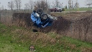
Driver charged after Highway 400 crash sends woman and child to hospital
One person has been charged following a collision on Highway 400 in Barrie Friday morning that sent a vehicle rolling into a ditch.
-
Barrie pharmacy launches 1st provincial pharmacist care walk-in clinic
The first provincial pharmacist care walk-in clinic has opened at the Rexall in the north end of Barrie to provide more immediate care for minor illnesses and chronic care in a more private setting.
-
Break-in leaves Barrie home with considerable water damage
Police are hoping to identify the person(s) who allegedly broke into a Barrie home and caused extensive water damage.
Kitchener
-

NDP leader likens Wilmot farmland grab to Greenbelt scandal
A controversial land acquisition proposed in Wilmot Township is once again in the spotlight, as Ontario NDP leader Marit Stiles hosts a town hall in the community, calling the deal “eerily similar” to the Greenbelt scandal.
-
'I'm still shaking': Emotional victim impact statements shared after impaired double-fatal crash in Cambridge
It was an emotional day in court as close to a dozen people read victim impact statements to the man charged with impaired driving in a double-fatal Cambridge crash.
-
Kitchener golfer recognized as creator of Masters skip-shot tradition
A Canadian Hall of Fame golfer from Kitchener is finally getting recognition for starting the skip-shot tradition at The Masters.
London
-
No more train trauma for Adelaide Street commuters
‘Onto Adelaide and just zip down’: Cars no longer have to deal with trains on Adelaide Street North, near Central Avenue.
-
Witness insists they are telling the truth at sexual abuse trial
A witness at the sexual assault trial involving parents is adamant the children involved in the trial are all telling the truth about what they had to endure during their upbringing.
-
City councillor says encampment response falls short and comes too late
A city councillor said she’s concerned the city is encouraging homeless encampments rather than finding more permanent solutions.
Windsor
-

'My family’s suffering still hasn’t ended': Faint hope hearing evidence concludes with victim impact statements
A Windsor man convicted in a violent murder 20 years ago awaits ruling on bid for early parole.
-
One driver charged, one sought after crash at apparent 'unsanctioned' rally
Windsor police have charged a 21-year-old man with stunt driving following a collision at a commercial property.
-
Seven Windsor record stores are the focus of a Record Store Day documentary screening
Windsor photographer and director Syx Langemann is hosting a free Record Store Day screening of his new docuseries ‘Spinning Stories’ that explores the recent resurgence in vinyl records.


