Josh Classen's forecast: The arctic air settles in this week

The heaviest snow missed the Edmonton region. But, we're not missing out on the cold and the wind.
AND...while the wind should ease up by Tuesday, the arctic air is sticking around all week.
In fact, it'll get even colder later in the week.
Today, we're looking at temperature pretty steady in the -10 C range with wind chill near -18 thanks to 20 km/h wind (gusts will be in the 30-40 km/h range).
No heavy snow, but possibly a few flurries in the area today and/or this evening. Otherwise, just cloudy skies.
Further east, winter storm warnings are in effect for east-central Alberta (Lloydminster/Vermilion south to Hanna-Coronation). Snow and near zero visibility thanks to gusty wind have prompted that warning.
The Medicine Hat region has a blowing snow advisory in effect. Conditions should gradually improve later today.
Back in Edmonton, we'll get daytime highs near -15 C Tuesday/Wednesday with a few flurries possible tomorrow. Wednesday's risk of snow has the potential to give us 2 to 5 cm accumulation.
Morning lows are expected to be near -20 C Wednesday and Thursday.
BUT...with some clearing Thursday afternoon, we could drop into the mid -20s (some models even projecting -30'ish) Friday morning and Saturday morning.
Daytime HIGHS will be in the -20 C range Thursday/Friday.
There's some uncertainty as we head into the weekend. I'm keeping the Edmonton region in the -15 C to -20 C range for daytime highs. But, there's a chance we break out of the arctic air over the weekend.
I'm thinking the cold will stick around at least through to early next week and possibly break towards the middle of next week. However, as I said - there's a good deal of uncertainty beyond Thursday/Friday.
So...we'll see how the week plays out and keep you updated.
One thing's for certain - It's getting COLD and we won't be back to near 0 C temperatures any time soon.
Here's the forecast for Edmonton and area:
Today - Cloudy with a few occasional flurries. Wind: NW 20 gusting to 40
High: -10 ***wind chill near -18 for most of the day
Tonight - Cloudy. 30% chance of a few flurries. Wind: NW 20 gusting to 40
9pm: -12 ***wind chill in the -20s overnight
Tuesday - Mostly cloudy. 30% chance of a few flurries. Light wind.
Morning Low: -16
Afternoon High: -14
Wednesday - Mostly cloudy. 60% chance of snow. 2-5 cm possible.
Morning Low: -19
Afternoon High: -15
Thursday - Clearing in the afternoon.
Morning Low: -20
Afternoon High: -18
Friday - Partly cloudy.
Morning Low: -26
Afternoon High: -20
Saturday - Mix of sun & cloud.
Morning Low: -25
Afternoon High: -16


CTVNews.ca Top Stories
B.C. woman facing steep medical bills, uncertain future after Thailand crash
The family of a Victoria, B.C., woman who was seriously injured in an accident in Thailand is pleading for help as medical bills pile up.
LIVE @ 4 EDT
LIVE @ 4 EDT Freeland to present 2024 federal budget, promising billions in new spending
Canadians will learn Tuesday the entirety of the federal Liberal government's new spending plans, and how they intend to pay for them, when Deputy Prime Minister and Finance Minister Chrystia Freeland tables the 2024 federal budget.
Annual inflation rate increased to 2.9% in March
The annual inflation rate ticked higher in March compared with February, boosted by higher prices for gasoline, Statistics Canada said Tuesday.
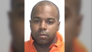
Inmate who escaped from N.B. prison has long history of violent crimes
An inmate who escaped from Dorchester Penitentiary in Dorchester, N.B., on Saturday evening has a long history of violent crimes and a history of escaping custody.
Tim Hortons launches pizza nationally to 'stretch the brand' to afternoon, night
Tim Hortons is launching flatbread pizzas nationally in a bid to pick up more afternoon and evening customers.
Thousands of dollars worth of tropical fish stolen from Ottawa Valley restaurant
Ontario Provincial Police are investigating the theft of "several thousand" dollars worth of tropical fish stolen from an Upper Ottawa Valley restaurant last week.
Ontario woman charged almost $7,000 for 20-minute taxi ride abroad
An Ontario woman was shocked to find she’d been charged nearly $7,000 after unknowingly using an unauthorized taxi company while on vacation in January.
NASA confirms mystery object that crashed through roof of Florida home came from space station
NASA confirmed Monday that a mystery object that crashed through the roof of a Florida home last month was a chunk of space junk from equipment discarded at the International Space Station.
Budget 2024 'likely to be the worst' in decades, former BoC governor says
Without having seen it, former Bank of Canada governor David Dodge believes that Tuesday's 2024 federal budget from Deputy Prime Minister and Finance Minister Chrystia Freeland is 'likely to be the worst budget' in decades.
Shopping Trends
The Shopping Trends team is independent of the journalists at CTV News. We may earn a commission when you use our links to shop. Read about us.


Calgary
-

Canada Pension Plan investment board to host public meeting in Calgary
The Canada Pension Plan (CPP) investment board will be hosting a public meeting from 6 to 8 p.m. on April 16 at the BMO Centre.
-
Jurors to hear closing arguments in trial for three men charged after Coutts blockade
Closing arguments are scheduled today for three men accused of orchestrating the border shutdown at Coutts, Alta., in early 2022.
-
Okotoks chosen to receive new EV charging stations
A community just south of Calgary is among eight Canadian municipalities that will have new charging stations installed as part of an Earth Day Canada campaign.
Lethbridge
-

Phillips calls for funding to be reinstated to Lethbridge Elder Abuse Response Network
Lethbridge West MLA Shannon Phillips is calling on the province to reinstate funding for the Lethbridge Elder Abuse Response Network.
-
Southern Alberta could be alive with the sound of rattlesnakes this weekend: expert
If you’re planning to head to the coulees this weekend to enjoy the nice weather, don’t forget to look down.
-
Lethbridge police team up with campaign to urge drivers to slow down
With the weather starting to feel like spring is really here, more kids will likely be outside enjoying the sunshine and warm temperatures, which organizers of the Slow Your Roll campaign say is a perfect time to re-launch the campaign.
Saskatoon
-
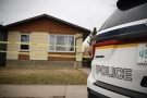
Saskatoon police declare suspicious death a homicide
Saskatoon police officers were called to 3206 33rd Street West Monday morning with reports of an “insecure property.” When they arrived, they found a woman dead in the basement.
-
Sask. struggling to recruit and retain specialists, doctor says
Dr. Ana-Maria Bosonea is the only allergist in Saskatoon seeing children under 12, and now she’s moving to Alberta.
-
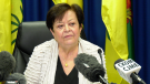
'Puppet show': Saskatchewan finance minister apologizes for text to Speaker
Saskatchewan's finance minister was ordered to apologize after she sent the Speaker a text accusing him of letting the legislature devolve into an 'Opposition puppet show' on Monday.
Regina
-
'Puppet show': Saskatchewan finance minister apologizes for text to Speaker
Saskatchewan's finance minister was ordered to apologize after she sent the Speaker a text accusing him of letting the legislature devolve into an 'Opposition puppet show' on Monday.
-
Not just flat: What tourism means to Saskatchewan
In Saskatchewan tourism generates over $2.4 billion in yearly spending and employs close to 71,000 people.
-
Fresh off move to new facility Regina Humane Society puts on record setting telethon
It was a record breaking evening for the Regina Humane Society this past weekend.
Vancouver
-

Suspect arrested after alleged assault on Vancouver officer at pro-Palestinian protest
Authorities have arrested a suspect who allegedly assaulted a Vancouver police officer during a pro-Palestinian protest last month.
-
Driver taken to hospital after truck crash downs utility pole in Surrey
Mounties in Surrey, B.C., say traffic is flowing once again after an overnight crash knocked out a utility pole and forced the closure of 184 Street between 32 Avenue and 40 Avenue.
-
LIVE @ 4 EDT
LIVE @ 4 EDT Freeland to present 2024 federal budget, promising billions in new spending
Canadians will learn Tuesday the entirety of the federal Liberal government's new spending plans, and how they intend to pay for them, when Deputy Prime Minister and Finance Minister Chrystia Freeland tables the 2024 federal budget.
Vancouver Island
-
B.C. woman facing steep medical bills, uncertain future after Thailand crash
The family of a Victoria, B.C., woman who was seriously injured in an accident in Thailand is pleading for help as medical bills pile up.
-
Planning next bid to rescue B.C. orca calf will take 'few days': Fisheries Department
The Department of Fisheries says planning for a new attempt to rescue an orca calf trapped in a Vancouver Island lagoon will be finalized in the next few days but no date has been set.
-
B.C. fraudster who lured investors with promise to help homeless fined by securities regulator
A Vancouver woman whose company duped investors by promising big returns on real-estate deals that would house the homeless has been ordered to pay nearly $626,000 after the British Columbia Securities Commission deemed the operation a Ponzi scheme.
Toronto
-

‘I just started crying:’ Blue Jays fan touched after act of kindness at recent game
Ontario resident Carla Norris-Hutcheson says she never expected to be gifted a Blue Jays jersey for her ailing husband when she sat alone at the team’s home opener next to a couple of kind strangers.
-
'Deplorable' conditions see sentences lowered at Toronto South Detention Centre: court
A growing number of judges presiding over Ontario's criminal cases are condemning 'deplorable' jail conditions at the Toronto South Detention Centre, where sentences continue to be shortened over inhumane conditions.
-
An Ontario family waited 3 years for trial in alleged murder of brother. Now they have to wait another year
An Ontario family that has waited three years for a trial in the alleged murder of a loved one has just been told they’ll have to wait another year.
Montreal
-

Recycling Montreal's Olympic Stadium roof: international competition collects bids
An international competition is hoping to gather new and interesting ways to recycle Montreal's Olympic Stadium roof, which is set to be dismantled this summer.
-
Montreal Canadiens recall Logan Mailloux from AHL
The Montreal Canadiens have recalled defenceman Logan Mailloux from the AHL's Laval Rocket.
-
3 people arrested in Quebec City for assault, threats, forcible confinement
Quebec City police say three people were arrested in connection with an alleged assault in the Beauport borough.
Atlantic
-
Inmate who escaped from N.B. prison has long history of violent crimes
An inmate who escaped from Dorchester Penitentiary in Dorchester, N.B., on Saturday evening has a long history of violent crimes and a history of escaping custody.
-
N.S. RCMP arrest man with 40 grams of cocaine, $2,000
Nova Scotia RCMP has arrested a 26-year-old man who allegedly tried to flee from officers in a vehicle and on foot Sunday night.
-
Halifax Transit bus involved in three-vehicle crash in city’s downtown
Halifax police have closed traffic on a portion of Barrington Street after a three-vehicle crash Tuesday morning.
Winnipeg
-

Manitoba Progressive Conservatives to elect new leader in April 2025
Manitoba Progressive Conservatives are to select a new leader on April 26 of next year.
-
12-year-old girl finds shotgun on Manitoba beach
Police are investigating after a 12-year-old girl found a sawed-off shotgun on the shores of a Manitoba beach.
-
Manitoba NDP raised and spent more money than the Tories in the election campaign
New figures show Manitoba New Democrats raised and spent more money than the Progressive Conservatives in last year's election campaign.
Ottawa
-
 LIVE @ 4 EDT
LIVE @ 4 EDT Freeland to present 2024 federal budget, promising billions in new spending
Canadians will learn Tuesday the entirety of the federal Liberal government's new spending plans, and how they intend to pay for them, when Deputy Prime Minister and Finance Minister Chrystia Freeland tables the 2024 federal budget.
-
Thousands of dollars worth of tropical fish stolen from Ottawa Valley restaurant
Ontario Provincial Police are investigating the theft of "several thousand" dollars worth of tropical fish stolen from an Upper Ottawa Valley restaurant last week.
-
OPP investigating after human remains found in Ottawa River in Clarence-Rockland
Ontario Provincial Police are investigating after human remains were found in the Ottawa River in Clarence-Rockland on Monday.
Northern Ontario
-

Northern Ont. driver missing after vehicle pulled into creek
Rescue crews are searching for a man reported missing on the weekend after the vehicle he was driving was pulled into a creek near the Quebec border in northern Ontario.
-
Ontario woman charged almost $7,000 for 20-minute taxi ride abroad
An Ontario woman was shocked to find she’d been charged nearly $7,000 after unknowingly using an unauthorized taxi company while on vacation in January.
-
Northern Ont. man acquitted of murder on James Bay coast
A northern Ontario family is devastated after a jury found a Moose Factory man not guilty of a 2021 murder.
Barrie
-

Casino Rama adds new shows to its 2024 performance lineup
Two new shows are coming to Casino Rama's Entertainment Centre for fans of country music and 80s rock.
-
Tribute to late 11-year-old Barrie boy vanishes again
A street sign in Barrie, renamed to honour 11-year-old Chase McEachern's legacy after he died in 2006, has gone missing again from an alleyway at the heart of the city's waterfront.
-
Parks Canada opens Couchiching Lock 42
Parks Canada advises that due to higher-than-normal water levels, a local lock will be opened
Kitchener
-

Driveway paving scammers reported in Waterloo Region
Cambridge resident Samantha Falkiner explains why something felt "off" about the men who approached her and her neighbours on Friday.
-
Policing costs for St. Patrick’s Day celebrations in Waterloo increased by $51,000
Waterloo Regional Police Services has released the estimated total cost for the St. Patrick’s Day weekend in the city of Waterloo.
-
Report of person with weapon prompts hold and secure in Delhi
A Delhi, Ont. street was placed in hold and secure Tuesday morning after police got reports of someone with a weapon.
London
-

As "bright as the sun': Students describe house fire near Fanshawe College
A number of students have been displaced after a house fire in east London near Fanshawe College. Crews were called to the scene on Prosperity Court late Monday night.
-
Traffic coming to a crawl on Main Street Exeter
Construction will slow down traffic moving through Exeter for the rest of the year. A reconstruction of the community's main street at the north end of town is underway.
-
Tax rebate from $31 million municipal surplus could unleash 'budget bomb'
A massive surplus remains from last year’s municipal budget in London, but city staff warned councillors against using it for a tax break this year.
Windsor
-

Woman arrested in Walkerville porch pirate investigation
Windsor police have arrested a 35-year-old woman related to a porch pirate investigation in Walkerville.
-
Windsor mother pushes for better addiction transitional supports amid doubling of opioid-related deaths
A new study published in a Canadian medical journal paints a bleak picture around opioid-related deaths in Canada. It shows the number of those deaths has more than doubled over a three-year period when the pandemic hit high gear.
-
LIVE @ 4 EDT
LIVE @ 4 EDT Freeland to present 2024 federal budget, promising billions in new spending
Canadians will learn Tuesday the entirety of the federal Liberal government's new spending plans, and how they intend to pay for them, when Deputy Prime Minister and Finance Minister Chrystia Freeland tables the 2024 federal budget.


