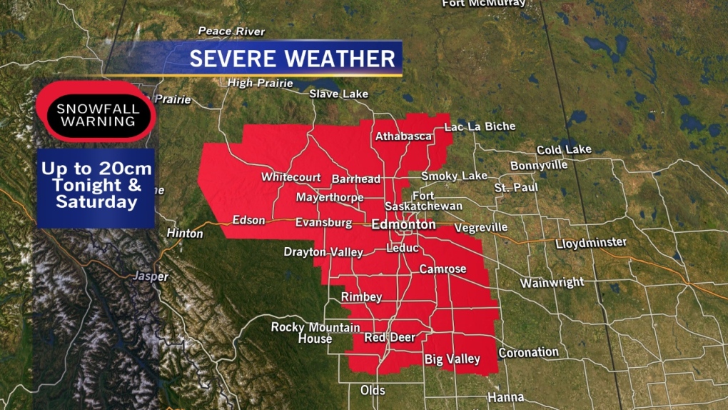
Snowfall WARNINGs are in effect for the City of Edmonton & surrounding areas.
That snow is expected to roll in from the WNW & should start overnight (in Edmonton).
By tomorrow morning, we'll likely have 2-5cm of snow on the ground. Another 5-10cm will fall through the day tomorrow and we may see 1-3cm early Sunday.
The snow is expected to taper off (in Edmonton) by Sunday afternoon. It may stick around longer for areas further SE (Red Deer, Wainwright, Coronation etc)
I'm sticking with my 10-20cm ballpark, but 10cm is starting to look more likely than 20cm.
The latest run of the GFS is moving the storm track a bit further south.
So, most areas NNE of Edmonton won't see any more than 5-10cm.
That means although Athabasca is "technically" in the warning zone, you won't get 10-20cm. You MIGHT get 5 or 6cm.
Environment Canada breaks down the province into forecast ZONES & one of those is: "Westlock-Barrhead-Athabasca".
Westlock & Barrhead could get 15cm and since Athabasca is in that "forecast zone", they get lumped into the warning.
Areas south of Edmonton (especially SE of the city) will get some of the heavier snowfall amounts. Wetaskiwin & Camrose areas are likely in for about 20cm of snow.
Wainwright/Coronation regions could get OVER 20cm.
Red Deer - about 15cm.
Calgary - 5-10cm.
On top of the snow, wind will be fairly gusty late Saturday into Sunday. So, icy roads AND reduced visibility.
If you have travel plans, especially WNW or S & SE of the Capital Region....you may want to put them off.
At the very least, be sure to check highway conditions on the AMA or 511 websites before heading out tomorrow.
Still looks like temperatures stay below average all next week. I'm thinking we'll have daytime highs in the 0 to 5 range.
The average high is 10.
LONG RANGE outlook doesn't have us in double digits until the 25th (at the earliest).
Here's the Edmonton forecast:
Today - Increasing cloud.
High: 4
Tonight - Snow starting overnight. 2-5cm.
Low: -3
Saturday - Periods of snow. 5-10cm possible.
High: 1
Sunday - Snow tapering off in the afternoon. 1-3cm possible.
Morning Low: -4
Afternoon High: 0
Monday - Mostly cloudy. 40% chance of flurries.
Morning Low: -5
Afternoon High: 0
Tuesday - Mix of sun & cloud.
Morning Low: -8
Afternoon High: 1
Wednesday - Mix of sun & cloud.
Morning Low: -5
Afternoon High: 3
Advertisement
More Snow! - April 12, 2013
CTV Edmonton
Published Friday, April 12, 2013 7:47AM MDT
Published Friday, April 12, 2013 7:47AM MDT
