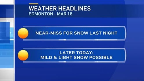
There's a chance of some snow moving into the Edmonton area from the NW this afternoon.
That snow might amount to 1-3cm.
BUT...the risk of heavy snow last night and this morning didn't pan out.
So...what happened?
Well, we figured it would be a fairly narrow band and that it would be over or near the Capital Region.
Late yesterday afternoon...most models had the heaviest snow staying over and north of Edmonton.
As it actually played out - the system stayed further south and so the rain and then heavy, wet snow stayed JUST south of the city.
Whitecourt was under a heavy snowfall warning and expecting 15-20cm....NOTHING there either.
Now - there IS still a chance of another wave of snow moving in NW Alberta later this morning.
That's the area of precipitation that may track towards and through the Edmonton area later this afternoon.
After today - Sunny and warm for Friday. Staying fairly warm through the weekend with a slight risk of precip Saturday night.
Spring officially starts at about 4:30am Monday. Daytime highs are projected to be in the 2-5 degree range for the first week of the new season.
Here's the Edmonton forecast:
Today - Mostly cloudy. 70% chance of snow this afternoon. 1-3cm possible.
High: 3
Tonight - Clearing overnight.
Evening: -1
Friday - Sunny with a few clouds.
Morning Low: -3
Afternoon High: 5
Saturday - Mix of sun & cloud. 30% chance of a rain/snow mix in the evening.
Morning Low: 0
Afternoon High: 6
Sunday - Mix of sun & cloud.
Morning Low: -3
Afternoon High: 4
Monday - Mainly sunny.
Morning Low: -12
Afternoon High: 2
Tuesday - Mainly sunny.
Morning Low: -7
Afternoon High: 4
Advertisement
WHERE'S THE SNOW? - March 16
CTV Edmonton
Published Thursday, March 16, 2017 9:02AM MDT
Published Thursday, March 16, 2017 9:02AM MDT
