
EDMONTON -- The weather is set to take an abrupt turn for the nastier in the Edmonton region and across much of north-central Alberta.
10-20 cm of snow, freezing rain and wind gusts near 100 km/h will affect various areas through the course of the day Wednesday.
We'll detail those warnings in a moment.
First, here's how this storm will likely play out in the Edmonton region (where we're under a freezing rain warning):
An area of freezing rain is expected to push through parts (if not all) of the Edmonton metro region and surrounding areas in the wee hours of the morning Wednesday.
This will probably happen sometime between midnight and 4 am. That will transition over to snow and the snow will continue through the morning hours before tapering off midday.
Roads will likely be slick through the morning commute due to the precip combo and visibility will be reduced in blowing snow with wind in the 20 gusting to 40 km/h range from about 7am to Noon.
The snow will taper off and then end by the afternoon. But, the wind will continue to intensify with gusts in the 50 to 60 km/h range through the afternoon hours and possibly into the early evening. Thankfully, temperatures will remain mild. We'll be around -2 in the morning and a degree or two above zero in the afternoon.
Snowfall accumulation will LIKELY be in the 2 to 6 cm range. But, there's an outside chance parts of the Edmonton region could get a bit more (especially to the north of the city).
Elsewhere: 10-20 cm of snow is expected in the snowfall warning zone which includes Jasper, Hinton-Grande Cache/Whitecourt-Edson and Slave Lake.
This snow will start overnight and end Wednesday morning. It will also be combined with gusts in the 40-50 km/h range.
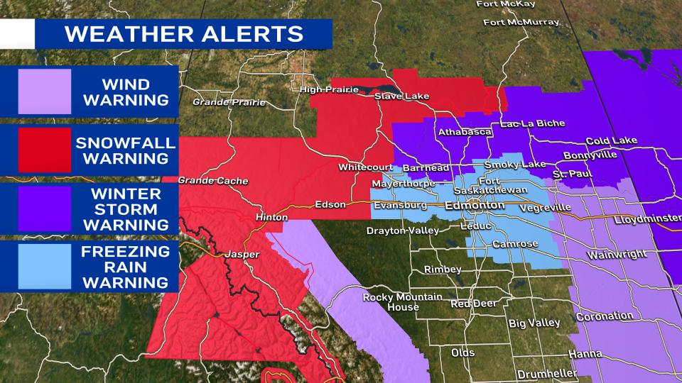
A winter storm warning is in effect for Westlock-Barrhead-Athabasca/Cold Lake-Bonnyville-St Paul-Lac La Biche. 10-20 cm of snow and a risk of freezing rain or mixed precipitation PLUS wind gusts in the 70-90 km/h range. This will start Wednesday morning and end late Wednesday afternoon/evening.
The Lloydminster-Vermilion region has both a freezing rain warning (for midday) AND a wind warning. The wind warning extends south through Hanna-Coronation and also includes Nordegg in the west and parts of southern Alberta. Gusts in the warning zone will likely be in the 70-100 km/h range. This is most likely to occur through the afternoon in the east.
It's important to note, this isn't the start of a major change in the weather pattern though. Most areas will be back to sun and light wind Thursday and temperatures will remain above average through the weekend.


