

Hourly updates of Thursday's storm across Alberta
With a risk of severe thunderstorms and potential for tornado development, CTV News Edmonton's meteorologists Josh Classen and Cory Edel will keep you updated throughout the day here.
- Damage from the storm south of Sundre, Alta.
- Funnel cloud images from the Sundre area
- Ping pong to golf ball size hail damage in Oyen, Alta.
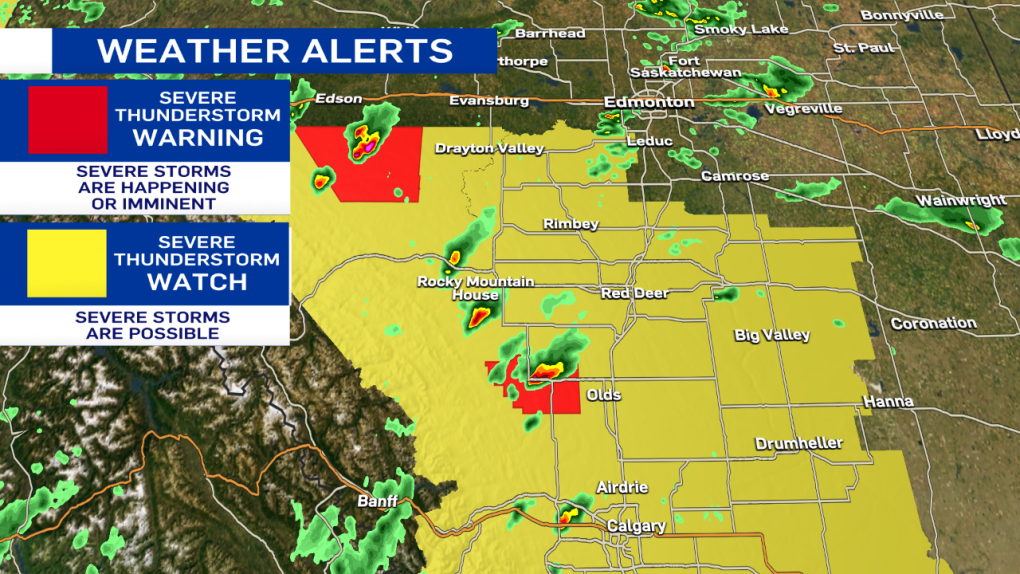
Josh Classen at 9:40 p.m.:
The storm system has now moved off to the NE of Edmonton and will continue to track away from the city. The severe thunderstorm warning has ended for the city and surrounding areas. No further storminess is expected in the city tonight.
Storms (severe in some spots) will continue in east-central Alberta tonight. We also have some storms in the Whitecourt region that will track move northeast this evening and overnight.
This will be the final update to this article. Thank you for following along.
Josh Classen at 9:15 p.m.:
The worst of the storm is moving out of the NE end of Edmonton. Fort Saskatchewan and area are next in line for the torrential downpours.
If you live in south Edmonton, you were mostly missed by the storm, with only a few spots getting some rain. The severe thunderstorm warning for the city of Edmonton will likely be ended soon.
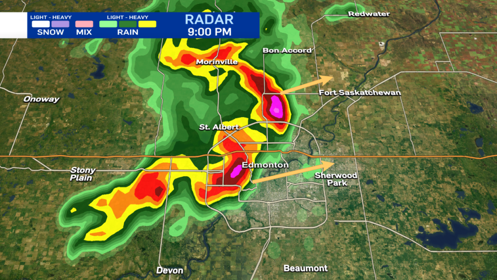
Josh Classen at 9:00 p.m.:
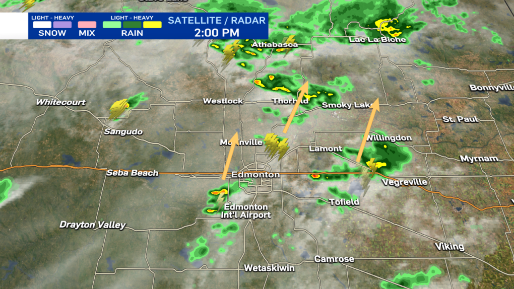
As the storm rips across Edmonton, most areas are just getting torrential downpours and some wind. A few areas are reporting small pea-sized hail. AND...it probably won't get more severe than that. Again, it's still looking like most areas should get about 30 min of nasty weather before conditions improve.
Josh Classen at 8:45 p.m.:
Storm will push across the city of Edmonton with heavy rain, strong wind gusts and possibly some pockets of hail. Most areas will only get intense rainfall. The storm should last for approximately 30 min for any given area, although it may not rain AS HEAVILY for that entire duration.
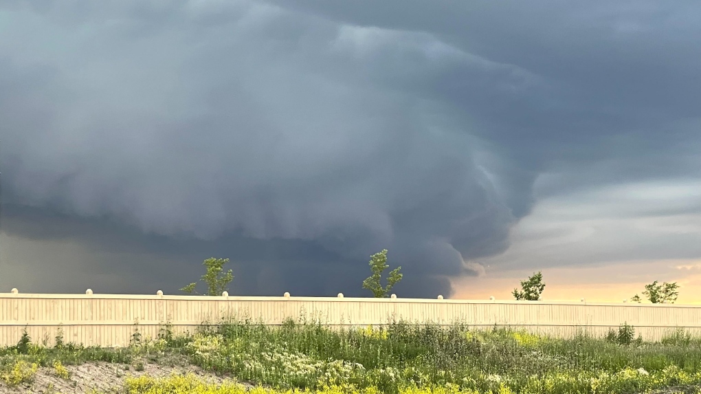 A storm cell moves toward north Edmonton on Thursday, July 7, 2022 (CTV News Edmonton/Sean McClune).
Josh Classen at 8:30 p.m.:
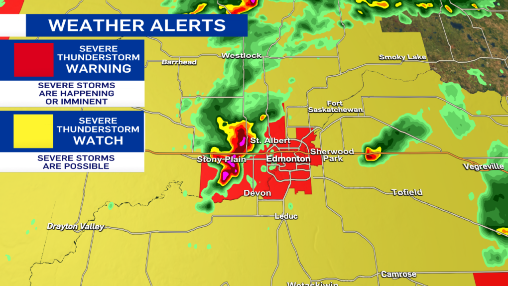
The city of Edmonton and surrounding areas are now under a Severe Thunderstorm WARNING. The storms are moving ENE at approx 30 km/h. Torrential downpours are the primary threat, along with strong wind gusts. Pockets of hail are possible as well.
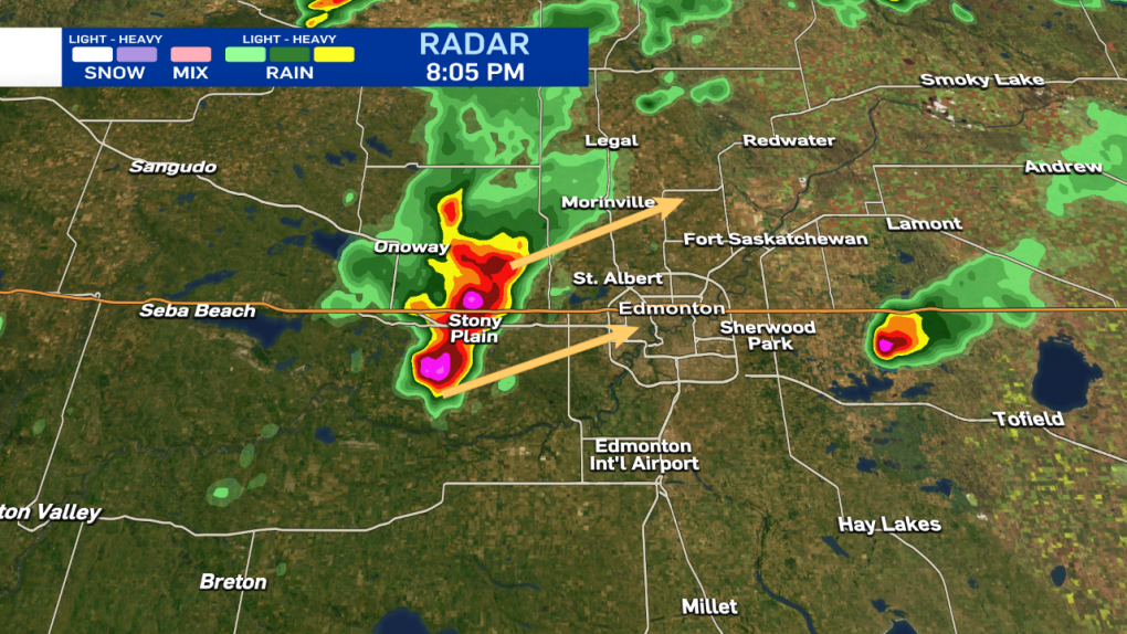
Josh Classen at 8:05 p.m.:
Severe storms in the Stony Plain/Spruce Grove region are moving ENE at about 30 km/h.
These storms are capable of producing toonie to ping pong ball-sized hail, downpours and strong wind gusts. It is likely that at least western and northwestern parts of Edmonton will get hit by these storms over the course of the next hour or two.
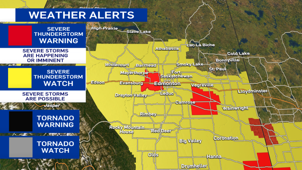
Also - here's the latest on the severe weather alerts. All of the tornado watches have been ended. Severe thunderstorm warnings and watches remain in effect.
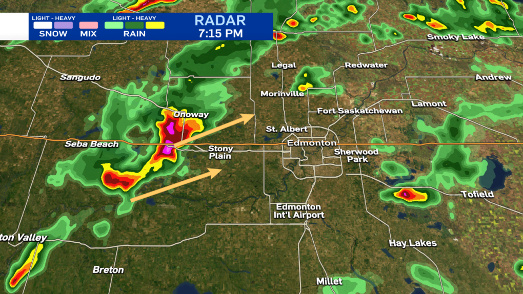
Josh Classen at 7:15 p.m.:
A severe storm just west of Stony Plain is slowly tracking northeast. Toonie to ping pong ball-sized hail, heavy rain and strong wind gusts are the main threats. That storm is part of a broken line of showers and storms heading NE. The nastiest storm (pink cell in the radar image) will likely miss the city (or at least the vast majority of it. But, Stony Plain and areas just north and NW of Edmonton could be in for quite the storm over the next few hours.
The concern for the city of Edmonton is the southern edge of that line. As it gradually inches further east, there is still the potential it could move into the city later this evening.
So...as I said at 6:30 - there's no imminent threat of a storm over the city. But, we're still not completely "out of the woods."
I'll continue to monitor the situation and send another update in an hour or so.
Josh Classen at 6:30 p.m.:
Thunderstorms continue to hit some areas SE of Edmonton and to the west near Lake Wabamun. However, aside from a few scattered showers, the city has been missed and MIGHT get missed altogether.
A severe thunderstorm WATCH remains in effect. However, the risk looks much lower than just an hour or two ago. IF we're going to get anything, it'll be later this evening as the line of storms from Drayton Valley to Onoway moves ENE. It appears that may slip past the city, though. We'll continue to monitor the situation. But, there is no imminent threat of severe weather at this point.
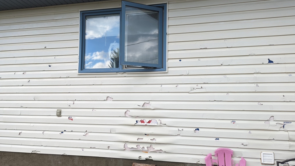 Hail damage after ping pong to golf ball sized hail hit Oyen, Alta., on Thursday, July 7, 2022 (Source: Tracy Hudson).
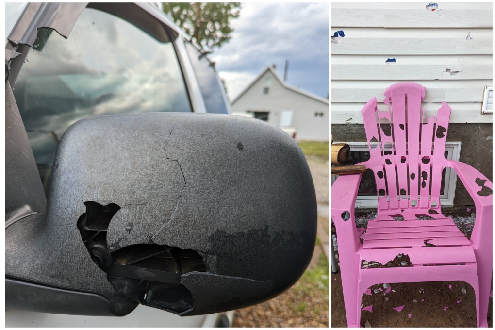 Hail damage after ping pong to golf ball sized hail hit Oyen, Alta., on Thursday, July 7, 2022 (Source: Tracy Hudson).
Josh Classen at 5:40 p.m.:
A severe thunderstorm WATCH remains in effect for the city of Edmonton. Right now, the storms "of concern" are just SE of the city and seem to be spinning back towards the NNW, potentially getting closer to Edmonton over the next hour. Those two storms near Hay Lakes are not severe as of now but may be producing some small hail and are definitely dropping heavy rain.
The severe storms near Seba Beach will slowly move NE, and most of that should pass north of Edmonton.
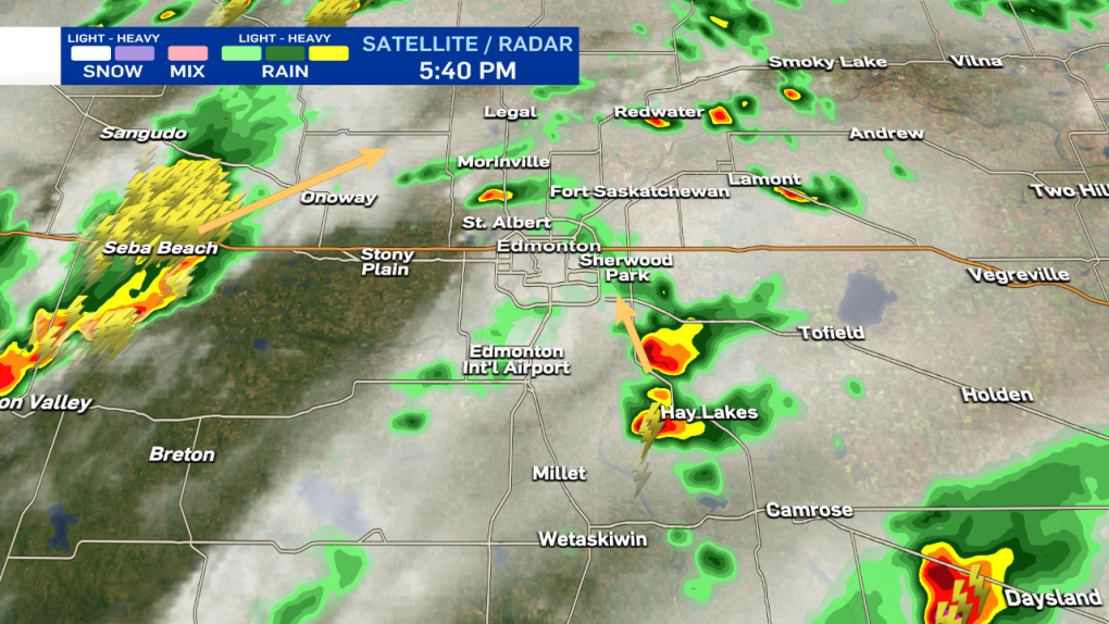
Here are the latest advisories, including Tornado WATCHes for the areas in grey (including Red Deer and Calgary).
Josh Classen at 4:55 p.m.:
The tornado warning for areas just west of Calgary has ENDED and has been replaced by a severe thunderstorm WARNING.
Isolated storms continue to close in on the Edmonton region and surrounding areas with the threat of severe storms continuing through this evening.
RCMP confirm to CTV News that the storm damaged approximately six to nine homes. Officers from Olds, Sundre, and Didsbury deployed to check on area residents, with everyone accounted for.
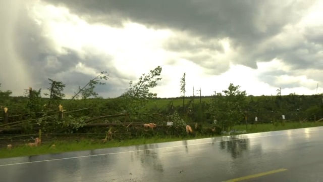 Damage visible east of Bergen, Alta., after a storm that produced a tornado on Thursday, July 7, 2022 (CTV News/Nav Sangha).
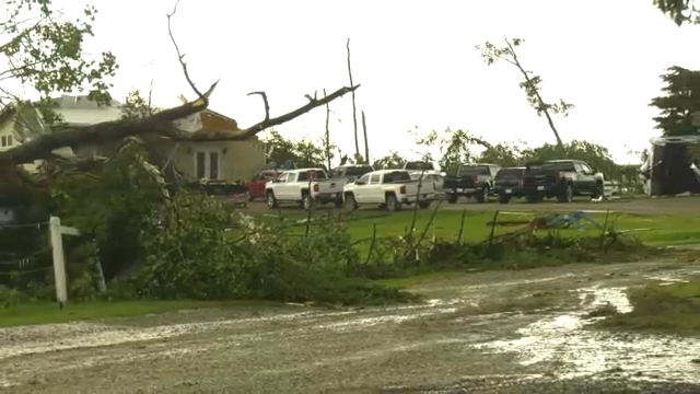 Damage visible east of Bergen, Alta., after a storm that produced a tornado on Thursday, July 7, 2022 (CTV News/Nav Sangha).
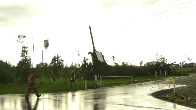 Damage visible east of Bergen, Alta., after a storm that produced a tornado on Thursday, July 7, 2022 (CTV News/Nav Sangha).
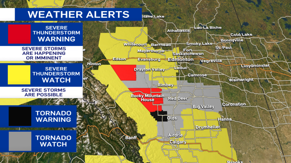
Josh Classen at 4:35 p.m.:
A tornado WARNING has been issued for a storm just northwest of Calgary. The storm may be producing a tornado and is 15 km south of Cochrane, heading east at 20 km/h.
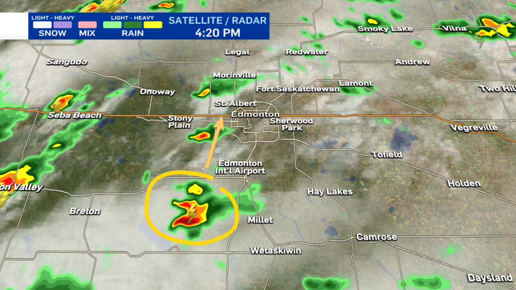
The storm that I mentioned earlier (west of Millet) has now been upgraded to a severe thunderstorm WARNING as it is likely producing up to toonie-sized hail and heavy downpours. That storm is moving north at 20 km/h towards Devon and the Edmonton region.
Josh Classen at 4:20 p.m.:
It's still a non-severe storm. But, we're keeping an eye on this cell west of Millet heading north towards the west end of the Edmonton region. We'll have more on all of this activity on CTV News Edmonton tonight at 5, 6 & late night at 11:30 p.m.
Josh Classen at 3:55 p.m.:
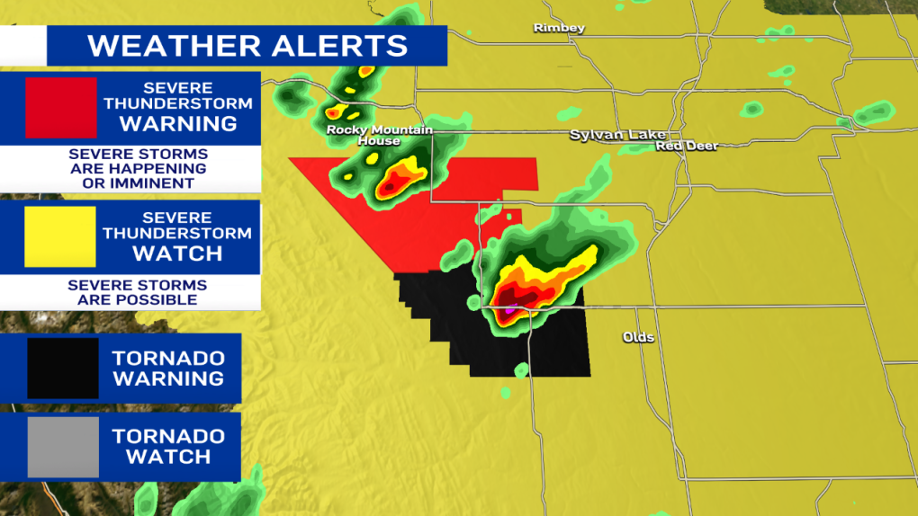
A severe thunderstorm WARNING has been issued for a storm west of Drayton Valley heading towards Drayton Valley. It is likely producing hail, as well as heavy downpours. Radar indicates this storm may also be possible of producing a tornado.
Another storm further west is has also turned severe with large hail likely.
The tornado warning has ENDED for the storm south of Sundre although that area just west of Olds continues to get pummeled with heavy rain and likely hail. The area is now under a severe thunderstorm WARNING.
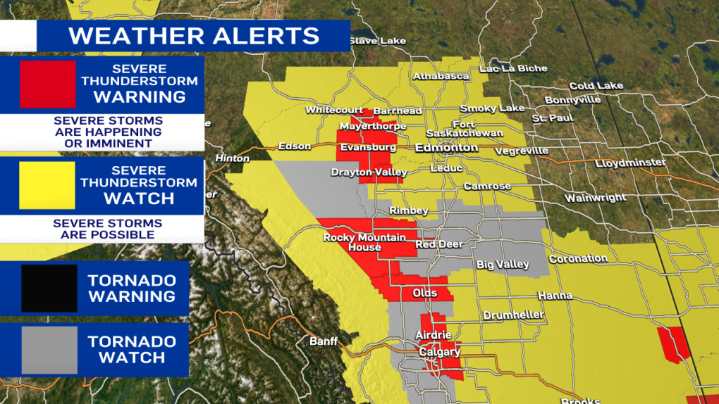
Josh Classen at 3:30 p.m.:
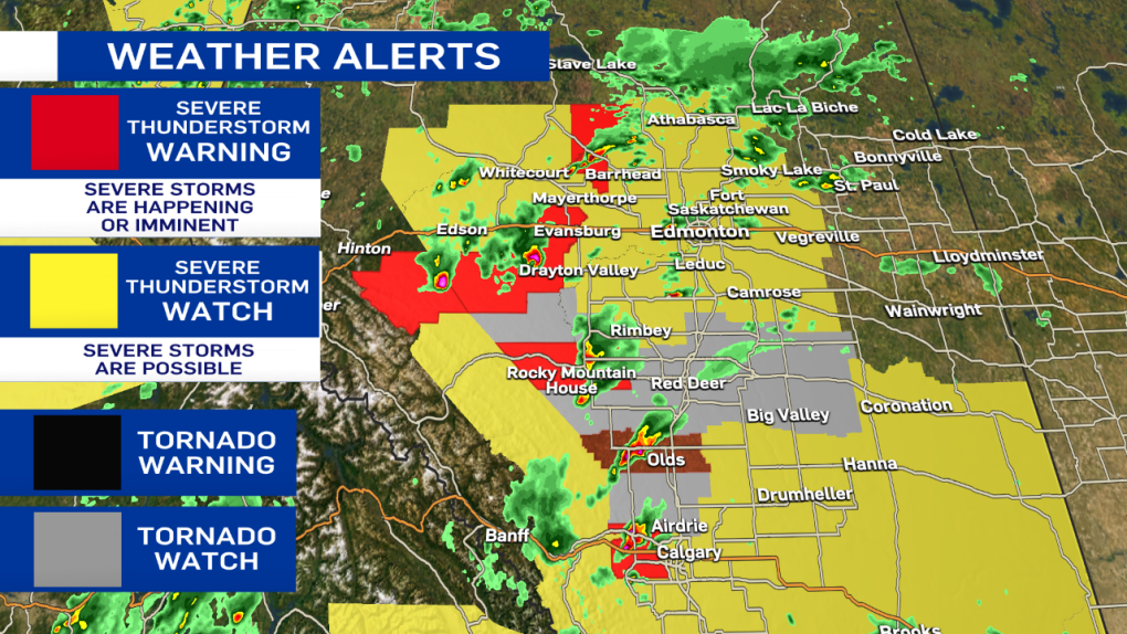
A Severe thunderstorm WATCH is now in effect for the City of Edmonton and regions to the north towards Athabasca and east towards Vegreville. This alert area will likely continue to be expanded further east this evening.
A WATCH means there is the potential for storms to turn severe. However, it remains important to note that most areas within that "watch zone" will not get severe weather. At this point, we don't have exact timing or location details for storms within the WATCH.
Severe Thunderstorm WARNINGs remains in effect for storms south of Edson, near Rocky Mountain House and just NW of Barrhead. All of those storms are moving NE and producing heavy downpours as well as hail.
A Tornado WARNING remains in effect for areas SE of Sundre (where there has already been a tornado).
A Tornado WATCH remains in effect for the areas in grey on the map including the city of Red Deer.
 A funnel cloud appears northwest of Didsbury, Alta. in July 2022. (Source: Braydon Morisseau/Prairie Storm Chasers).
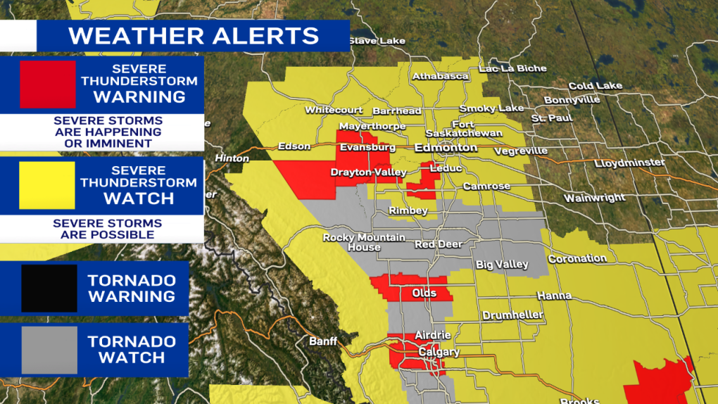
Josh Classen at 3 p.m.:
A tornado WATCH is in effect for the areas in grey on the map. This means conditions are favourable for the development of severe thunderstorms that might produce a tornado.
A tornado WARNING remains in effect for a storm about 10 km south of Sundre. A tornado has been spotted near Bergen, and the storm is slowly moving ENE but remains a long way away from the QE2.
*** It's important to remember that most areas under a WATCH will not see any severe weather, but have the POTENTIAL for severe storms. Be aware of your surroundings, and stay tuned to weather alerts as they develop. The main threat of severe weather remains over areas south of the Edmonton region. The city sits on the northern end of the risk zone, and while severe storms are possible, they are far from guaranteed.
Josh Classen at 2:37 p.m.:
A tornado WARNING has been issued for areas near Sundre, and storm-chaser Kyle Brittain is in the area reporting a tornado touchdown near Bergen, just south of Sundre. The storm is SLOWLY moving NNE. People in that area should immediately seek shelter.
Josh Classen at 2:30 p.m.:
The Severe Thunderstorm WATCH area has extended further north to include Whitecourt/Mayerthorpe, Edson, Evansburg and areas just west of Edmonton, including Stony Plain and Spruce Grove. The city of Edmonton still isn't under an advisory. But, that may change later this afternoon as the storms continue to develop.
Josh Classen at 2:15 p.m.:
A small non-severe thunderstorm SW of Edmonton is moving NNE and should slide through western parts of the Edmonton metro region. The primary risk for powerful and possibly severe storms remains late this afternoon and early this evening.

A severe storm has developed west of Olds and is moving NE toward Bowden and Innisfail. Heavy rain and large hail are the main threats from this storm cell.
Another severe storm south of Edson is also likely producing hail as well as heavy downpours. This storm is moving also moving NE.
Cory Edel at 11:45 a.m.:
A Severe Thunderstorm Watch has now been issued by Environment Canada for areas just south and southwest of Edmonton.
Drayton Valley and Wetaskiwin are included in this watch area which extends south to the U.S. border. Conditions continue to ripen, with severe thunderstorms becoming more likely as we get into the late afternoon and evening.
Although Edmonton is not included in the Severe Thunderstorm Watch, that could change as storms start to develop and storm threat and path becomes clearer.
Remember, the dangers of severe thunderstorms include lightning, strong damaging winds and hail, along with heavy localized rain. In extreme cases, severe thunderstorms can produce tornadoes. If you find yourself in a situation with large storm clouds moving in, best to head inside until they pass through the area.
There is a saying, "When thunder roars, go indoors," a reminder that conditions could be changing quite quickly. Stay informed with us as we continue to follow this developing weather situation over Edmonton and central Alberta.
Cory Edel at 8 a.m.:
We're kicking off this Thursday with sun and cloud, seemingly quiet, but there is a good chance that will change as we head into the afternoon.
Today's weather conditions are favourable for the development of potentially severe thunderstorms through central areas of Alberta, including Edmonton.
These storms could produce large hail, strong wind and localized heavy rainfall.
With severe thunderstorms, there is also potential for tornado development. These storm cells could see some good rotation, and with that rotation and low level shear, the risk for tornadoes will be present later today. The greatest risk for this is south of the city, as Edmonton will be on the north-eastern edge of the severe storm risk area.
As far as timing, we will start to see some of these storms kick up off the foothills and pull to the northeast through the afternoon. For Edmonton, it's looking like we see the risk of the storms around the supper hour into the mid evening, about 5 p.m. to 9 p.m. If you are heading to the Edmonton Elks game tonight or have outdoor activities planned, it will be a good idea to be prepared to change your plans with this potentially fast-changing weather.
The storms will likely continue to pull to the east and northeast areas of the province later tonight and into the early morning hours. We will be keeping an eye on this developing severe-weather situation and follow up with any severe thunderstorm and possible tornado warnings issued by Environment Canada.
Join us on CTV News at 5 and 6 with Josh Classen as he tracks the development of these storms.
Shopping Trends
The Shopping Trends team is independent of the journalists at CTV News. We may earn a commission when you use our links to shop. Read about us.


CTVNews.ca Top Stories

Calgary woman stranded in Mexico after husband's death during diving trip
A Calgary woman is struggling to return home after her husband died while diving in Mexico, leaving her stranded and facing financial hardship.
Fugitive U.S. rioter seeks asylum in Whistler amid warnings of more to come
An American citizen convicted of participating in the Jan. 6, 2021, riot on Capitol Hill and dodging jail time in Whistler may just be the start of an asylum-seeking rush, according to a prominent legal expert.
Special national Liberal caucus meeting called for next week after regional chairs meet: sources
A special meeting of Prime Minister Justin Trudeau's national Liberal caucus has been called for next Wednesday, sources say.
N.S. community shocked by deaths of father, daughter; suspect was wanted in Toronto shooting
A Nova Scotia community is mourning the loss of two of its members after they were shot and killed in Halifax on New Year's Eve.
Canada pausing applications for parent, grandparent permanent residency sponsorships
Canada will not accept new parent and grandparent permanent residency sponsorship applications until further notice, according to a ministerial directive.
Soldier who blew up Tesla at Trump hotel left note saying blast was to be a 'wakeup call' for the U.S.
A highly decorated Army soldier who fatally shot himself in a Tesla Cybertruck just before it blew up outside the Trump hotel in Las Vegas left notes saying the New Year's Day explosion was a stunt to serve as a “wakeup call” for the country’s ills, investigators said Friday.
Sea and Himalayan salts recalled in Canada: 'Do not use, serve or distribute'
Two brands of sea and Himalayan salt are being recalled in Canada due to pieces of plastic found in the products.
'Inadmissible' foreign nationals to pay more upon return to Canada: CBSA
Foreign nationals who refuse or are unable to pay their own way home after being denied stay in Canada will soon face steeper financial penalties should they ever attempt to return.
'It's about time': Experts in Canada support call for warnings about cancer risk from alcohol
While Canada hasn't mandated cancer warnings for alcoholic beverages, a few experts are supporting a new push in the U.S. to have the labels on the products.
Calgary
-
Calgary woman stranded in Mexico after husband's death during diving trip
A Calgary woman is struggling to return home after her husband died while diving in Mexico, leaving her stranded and facing financial hardship.
-
Calgary police seek driver of 'red vehicle' wanted in serious hit-and-run on Memorial Drive
Calgary police are hoping to gain more information from the public on a hit-and-run in November that badly injured one person.
-
Third person charged with first-degree murder in Lethbridge motel death
A third person has been charged with first-degree murder after a woman was found dead in a Lethbridge motel room over the weekend.
Lethbridge
-

Third person charged with first-degree murder in Lethbridge motel death
A third person has been charged with first-degree murder after a woman was found dead in a Lethbridge motel room over the weekend.
-
Businesses see influx of customers working on New Year's resolutions
Marketing research company Sago estimates about 43 per cent of Canadians will make a New Year's resolution.
-
2 charged with first-degree murder in Lethbridge motel death
Lethbridge Police have charged two people with first-degree murder, after a body was found in a southside motel room last weekend.
Saskatoon
-

$20k of equipment stolen from rural Sask. Fire hall. And it's not the only one
Rural firehalls surrounding Saskatoon are having to deal with escalating thefts that could put rescue efforts in jeopardy.
-
Two people charged with murder after suspicious death on Sask. First Nation
A man and a woman have been charged with first degree murder after a 24-year-old man died of injuries on Saulteaux First Nation.
-
Inmate who escaped federal prison in Saskatchewan arrested
After about five months of searching, police have arrested Jareth Gardipy-Taypotat, who escaped from the Willow Cree Healing Lodge, a minimum-security federal institution north of Saskatoon.
Regina
-

Sask. RCMP investigating woman's death on Piapot First Nation
Saskatchewan RCMP says it is investigating the death of a 30-year-old woman on Piapot First Nation as suspicious in nature.
-
SaskAbilites Yorkton enhances relaxation room
SaskAbilities Yorkton has enhanced their relaxation room to help people with disabilities experience a more comfortable and calming environment.
-
CTV Regina's top trending stories of 2024
Whether it was hard news or light-hearted features, the year of 2024 hosted some very compelling stories – with several being widely shared online and reaching new audiences.
Vancouver
-

Fugitive U.S. rioter seeks asylum in Whistler amid warnings of more to come
An American citizen convicted of participating in the Jan. 6, 2021, riot on Capitol Hill and dodging jail time in Whistler may just be the start of an asylum-seeking rush, according to a prominent legal expert.
-
Former Four Seasons Hotel in downtown Vancouver to be demolished
A former luxury hotel tower in downtown Vancouver is slated to be demolished.
-
Accused in armed robbery at Vancouver Holt Renfrew has prior convictions
The 66-year-old man accused of holding up a Holt Renfrew in downtown Vancouver this week has prior convictions, including for two other robberies that involved fake guns.
Vancouver Island
-

B.C. driver who tried to apprehend suspected impaired driver was impaired: RCMP
Mounties on Vancouver Island say a 50-year-old motorist who tried to apprehend a suspected impaired driver on New Year's Eve, was, in fact, impaired and was issued a 90-day driving prohibition by police.
-
Attending hundreds of serious crash scenes each year takes its toll, B.C. first responders say
Just days into the new year, officials are already pleading with British Columbians to follow the rules of the road.
-
Woman, 63, dead after collision on Vancouver Island
A 63-year-old woman is dead after the car she was driving collided with a truck on southern Vancouver Island.
Toronto
-

2 Royal Military College students jumped into action to save a man from a burning car in North York
A black Ford Mustang had lost control while traveling north along Bayview, crashing into cement pillars near the stores loading dock.
-
Union representing Ontario college faculty issues five-day strike notice
Ontario college students could soon see their winter semester cut short as the union representing faculty at the province’s 24 public colleges could walk off the job as early as Thursday next week.
-
Ontario aiming to send out $200 rebate cheques later this month or early February
Ontarians should receive their $200 rebate cheque from the province by the end of January or early February, a government spokesperson confirmed in an email Friday.
Montreal
-

Lachine tenants have been out of heat and hot water for 2 months
A 47-unit building hasn't had hot water for nearly two months, and the heat is out too, forcing the city to intervene.
-
More homeless people hiding from the cold in Montreal's crowded ERs
When warming centres are full, homeless people with nowhere to go are turning to emergency rooms.
-
Montreal police make 2 more arrests in killing of Claudia Iacono
Montreal police have arrested two more suspects in the slaying of Claudia Iacono.
Atlantic
-

N.S. community shocked by deaths of father, daughter; suspect was wanted in Toronto shooting
A Nova Scotia community is mourning the loss of two of its members after they were shot and killed in Halifax on New Year's Eve.
-
Saint John man charged with second-degree murder in wife’s Christmas Eve death
A man accused of murdering his wife on Christmas Eve made his first court appearance in Saint John, N.B., Friday morning.
-
Winter storm watch issued in Cape Breton; Weather statements expanded in N.S. and P.E.I.
A major winter storm is expected to hit eastern parts of the Maritimes Sunday into Monday.
Winnipeg
-

'Hopeful that we can make this go': Potential $5.25 million bid made for Lemay Forest
There is a new offer to buy and preserve the Lemay Forest.
-
New train detection system on track to alert motorists, first responders about railway traffic
Winnipeg may soon see a new train detection system that lets motorists know when to use alternate routes and avoid railway crossings.
-
Manitoba authorities investigate record 99 homicides in 2024
Manitoba hit a grim record in 2024 – reaching the highest number of homicides being investigated.
Ottawa
-

Highrise fire on Ramsey Crescent displaces 39 residents, injures 16
The Ottawa Paramedic Service says four adult women were taken to hospital following a fire that happened in a highrise on Ramsey Crescent, in the west end of Ottawa, in the early hours of Friday morning.
-
Man, woman seriously injured following multi-vehicle collision on Bank Street
A man and a woman were seriously injured following a multi-vehicle collision on Bank Street at Lester Road Friday afternoon, according to the Ottawa Paramedic Service.
-
OTTAWA'S LRT
OTTAWA'S LRT All aboard Ottawa's new LRT line: What you need to know about the new north-south Line 2 and Line 4
Ottawa’s new north-south rail line will open to the public on Monday, Jan. 6, connecting downtown Ottawa and Riverside South with a spur to the Ottawa International Airport.
Northern Ontario
-

Suspect charged in northern Ont. road rage incident that went viral
A 37-year-old suspect has been charged in connection with a road rage incident last week in Temiskaming Shores.
-
Northern staff react to Ontario college faculties issuing five-day notice of labour action
College faculty in Ontario gave its five-day notice of starting labour action on Friday, which could include a strike or some other work stoppage at the 24 schools within the province.
-
Sault, Ont., man claims Indigenous moose hunting rights without proof, fined $5,500
A hunter from Sault Ste. Marie, Ont., has been fined for moose hunting without a licence or proper documentation. He claimed Indigenous hunting rights but failed to provide any proof.
Barrie
-

Persistent snow squalls bring heavy accumulations to Barrie area
Environment Canada is maintaining its snow squall warning for most of central Ontario on Friday.
-
Warrant issued for allegedly armed and dangerous man wanted for attempted murder
Police in York Region have issued an arrest warrant for one man following a reported shooting at a motel in Queensville.
-
Fail-to-remain driver busted hours after collision
A Cambridge man was busted in Caledon for a Brampton collision.
Kitchener
-

Snow squall warnings for southwestern Ontario
Environment Canada says southwestern Ontario could get between 15 and 60 centimetres of snow by Saturday.
-
Union representing Ontario college faculty issues five-day strike notice
Ontario college students could soon see their winter semester cut short as the union representing faculty at the province’s 24 public colleges could walk off the job as early as Thursday next week.
-
Volunteers get ice rinks ready for skating season
Now that there’s a stretch of sub-zero temperatures in the forecast, volunteers have been busy getting ice rinks ready for skaters.
London
-

'Justice has been done': Man who fatally shot teen at bush party guilty of second degree murder
Carlos Guerra Guerra has been found guilty of second-degree murder in the 2021 bush party murder trial.
-
Road conditions deteriorate in areas north of London
Several areas in midwestern Ontario have had a snow squall watch upgraded to a snow squall warning.
-
College faculty could walk off the job as of January 9
Following months of anticipation, discussion, and bargaining, the Ontario Public Service Employees Union (OPSEU) is one step closer to walking off the job.
Windsor
-

2.99% tax increase in proposed 2025 Windsor budget
The proposed 2025 City of Windsor budget includes a 2.99 per cent tax increase.
-
-
'It was a privilege to work alongside him': Habitat for Humanity Windsor-Essex joins worldwide memorial for Jimmy Carter
Habitat for Humanity Windsor-Essex is joining a worldwide memorial for late U.S. President Jimmy Carter.


