Josh Classen's forecast: Cooler with sunny breaks and possible midday showers

Rain moved through the Edmonton area overnight and delivered about five to 10 mm across the city.
As we discussed Tuesday afternoon, the band of heavier rain has set up and will stall out north of the Edmonton region through this morning.
In the city and surrounding areas, we'll get some sunny breaks this morning. Then, another chance of showers midday as the flow switches and starts to come from the north.
We're getting some steadier rain this morning in a line roughly from Grande Cache through Whitecourt, Athabasca and St. Paul.
Rainfall warnings remain in effect for the west end of that line, especially north of highway 16.
Sidebar: I mentioned it last night on air, but it's worth repeating: Hinton and Edson are under the rainfall warning, but only on a technicality and they won't get as Grande Cache, Fox Creek and Whitecourt areas.
That's because of the way warnings are issued. The forecast zones are: Hinton-Grande Cache and Whitecourt-Edson.
SO...Hinton won't get warning-worthy rainfall amounts, but Grande Cache will...and, as a result...both locations get the warning because one part of the forecast zone will be affected.
Back to the Edmonton area. As the line of showers north of the city starts to push back to the south later this morning, there's some question about whether it'll fall apart or remain intact.
There's no guarantee we'll get some midday showers in the city, but I think there's a better chance of seeing SOMETHING than NOTHING.
So...the morning's nice...lunch could get a bit wet...then back to some sunny breaks for the mid-afternoon.
Finally - we get another chance of some showers or isolated thunderstorms in Edmonton and north-central AB this evening.
That risk looks a bit lower than the midday possibility (at least, for Edmonton and area).
Temperatures will probably stay short of 20 C this afternoon. I'm going with a high of 18 C for later today.
But, that'll depend on whether or not we see some showers and when they hit.
We'll get back to the low 20s Thursday afternoon with a bit more sun. Just a slight risk of an isolated shower popping up in the area late in the day.
(I've left that risk out of the forecast for now)
The long-range outlook for the long weekend continues to trend cooler.
I've been talking about a range of 22 to 27 for daytime highs Fri/Sat/Sun.
But...just a day or two, I really thought we'd probably be at the higher end of that range.
NOW...I think we'll be hard-pressed to break 25 C. Still possible, but less likely.
That said - the outlook has been "evolving" quickly and some uncertainty remains.
Here's the forecast for Edmonton and area:
Today - Mix of sun & cloud this morning. Mostly cloudy this afternoon.
60% chance of showers midday.
High: 18
Tonight - 40% chance of a shower or isolated thunderstorm early this evening. Cloudy periods overnight.
9pm: 15
Thursday - Partly cloudy.
Morning Low: 10
Afternoon High: 23
Friday - Partly cloudy. 60% chance of a late-day shower or thunderstorm.
Morning Low: 11
Afternoon High: 25
Saturday - Mix of sun & cloud.
Morning Low: 12
Afternoon High: 22
Sunday - Partly cloudy.
Morning Low: 12
Afternoon High: 24
Monday - Mix of sun & cloud.
Morning Low: 12
Afternoon High: 21


CTVNews.ca Top Stories
RCMP uncovers alleged plot by 2 Montreal men to illegally sell drones, equipment to Libya
The RCMP says it has uncovered a plot by two men in Montreal to sell Chinese drones and military equipment to Libya illegally.
Demonstrators kicked out of Ontario legislature for disruption after failed keffiyeh vote
A group of demonstrators were kicked out of the legislature after a second NDP motion calling for unanimous consent to reverse a ban on the keffiyeh failed to pass.
Tom Mulcair: Park littered with trash after 'pilot project' is perfect symbol of Trudeau governance
Former NDP leader Tom Mulcair says that what's happening now in a trash-littered federal park in Quebec is a perfect metaphor for how the Trudeau government runs things.
Government agrees to US$138.7M settlement over FBI's botching of Larry Nassar assault allegations
The U.S. Justice Department announced a US$138.7 million settlement Tuesday with more than 100 people who accused the FBI of grossly mishandling allegations of sexual assault against Larry Nassar in 2015 and 2016, a critical time gap that allowed the sports doctor to continue to prey on victims before his arrest.
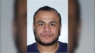
Man wanted in connection with deadly shooting in Toronto tops list of most wanted fugitives in Canada
A 35-year-old man wanted in connection with the murder of Toronto resident 29-year-old Sharmar Powell-Flowers nine months ago has topped the list of the BOLO program’s 25 most wanted fugitives across Canada, police announced Tuesday.
Doctors ask Liberal government to reconsider capital gains tax change
The Canadian Medical Association is asking the federal government to reconsider its proposed changes to capital gains taxation, arguing it will affect doctors' retirement savings.
Keeping these exotic pets is 'cruel' and 'dangerous,' Canadian animal advocates say
Canadian pet owners are finding companionship beyond dogs and cats. Tigers, alligators, scorpions and tarantulas are among some of the exotic pets they are keeping in private homes, which pose risks to public safety and animal welfare, advocates say.
Thieves use stolen forklift to rip cash machine out of U.K. bank
Police in the U.K. are searching for a group of suspects seen on video using a forklift to steal a cash machine from a bank.
'There was a lot of black smoke': Crane operator sounds alarm while trapped during highrise fire in Halifax
A tower crane operator alerted emergency crews after noticing a fire on a construction site in Halifax Tuesday morning.
Shopping Trends
The Shopping Trends team is independent of the journalists at CTV News. We may earn a commission when you use our links to shop. Read about us.


Calgary
-

Inflation 'eroding' the ability of Albertans to buy a home: RBC poll
Many Albertans may be looking for a side hustle or to family members to help cover the high cost of housing, a new poll suggests.
-
Calgary lawyer launches clothing line to champion Charter rights
A Calgary criminal defence lawyer has launched a clothing campaign to promote awareness about the Canadian Charter of Rights and Freedoms.
-
Star-studded country lineup announced for Nashville North 2024
The Calgary Stampedehas announced the 2024 lineup for the Nashville North stage.
Lethbridge
-

Southern Alberta woman wins $2M on Western 6-49 lottery
A southern Alberta woman says she began to hyperventilate when she realized she had won $2 million.
-
Lethbridge green cart program a success one year in, city says
The City of Lethbridge is calling the first year of its curbside organics waste collection program a success.
-
Coaldale RCMP seek information on hit-and-run
Coaldale RCMP are looking for the public's help to locate a suspect in a hit-and-run in a McDonald's parking lot earlier this month.
Saskatoon
-

WATCH LIVE: PM Trudeau making budget announcement in Saskatoon
Prime Minister Justin Trudeau is scheduled to make an announcement about budget measures for youth and education during a visit to Saskatoon’s Wanuskewin heritage park on Tuesday morning.
-
Sask. broker says halal mortgages are not a new concept in Canada
A Saskatoon mortgage broker says the federal government’s move to help Muslim Canadians get into the housing market by promoting halal mortgages is not such a radical idea — it’s helping families buy their first home without breaking their faith.
-
Sask. driver caught using vice grips in place of steering wheel
A driver caught using vice grips in place of a steering wheel was ticketed Wednesday after being stopped by police on a rural road.
Regina
-
WATCH LIVE: PM Trudeau making budget announcement in Saskatoon
Prime Minister Justin Trudeau is scheduled to make an announcement about budget measures for youth and education during a visit to Saskatoon’s Wanuskewin heritage park on Tuesday morning.
-
One year after fatal collision, Regina council has final say on lower speed limit in Cathedral
Regina city councillors are set to consider lowering the speed limit in the Cathedral neighbourhood to 30 kilometres per hour on Wednesday.
-
Sask. NDP leader combats claims of carbon tax support following Ottawa visit
Members of the Sask. Party claim a recent trip by the leader of the opposition reveals her party's secret support for the federal carbon tax.
Vancouver
-

Body found by U.S. authorities searching for missing B.C. kayakers: RCMP
Mounties in British Columbia say United States authorities who have been searching for a pair of missing kayakers near Vancouver Island have recovered a body in the nearby San Juan Islands of Washington state.
-
'Do the right thing': Surrey RCMP ask hit-and-run driver to come forward
Police in Surrey are asking the person who was behind the wheel of a grey pickup truck that struck a pedestrian and fled the scene on Sunday to come forward. They're also seeking witnesses to the hit-and-run collision.
-
Pedestrian, baby injured after stroller struck and dragged by vehicle in Squamish, B.C.
Police say a baby and a pedestrian suffered non-life-threatening injuries after a vehicle struck a baby stroller and dragged it for two blocks before stopping in Squamish, B.C.
Vancouver Island
-
Body found by U.S. authorities searching for missing B.C. kayakers: RCMP
Mounties in British Columbia say United States authorities who have been searching for a pair of missing kayakers near Vancouver Island have recovered a body in the nearby San Juan Islands of Washington state.
-
Police release details about suspect vehicle after fatal B.C. hit-and-run crash
Mounties searching for a driver who struck and killed a woman on Vancouver Island last week released new details about the suspect vehicle Monday.
-
Pedestrian, baby injured after stroller struck and dragged by vehicle in Squamish, B.C.
Police say a baby and a pedestrian suffered non-life-threatening injuries after a vehicle struck a baby stroller and dragged it for two blocks before stopping in Squamish, B.C.
Toronto
-

Man wanted in connection with deadly shooting in Toronto tops list of most wanted fugitives in Canada
A 35-year-old man wanted in connection with the murder of Toronto resident 29-year-old Sharmar Powell-Flowers nine months ago has topped the list of the BOLO program’s 25 most wanted fugitives across Canada, police announced Tuesday.
-
Toronto's police chief clarifies initial statement on Umar Zameer acquittal, says he 'accepts' jury's finding
Toronto's Chief of Police has clarified a statement that he'd hoped for "a different outcome" made just after Umar's Zameer acquittal, telling reporters Tuesday he supports and accepts the jury's finding in the five-week trial.
-
Demonstrators kicked out of Ontario legislature for disruption after failed keffiyeh vote
A group of demonstrators were kicked out of the legislature after a second NDP motion calling for unanimous consent to reverse a ban on the keffiyeh failed to pass.
Montreal
-
RCMP uncovers alleged plot by 2 Montreal men to illegally sell drones, equipment to Libya
The RCMP says it has uncovered a plot by two men in Montreal to sell Chinese drones and military equipment to Libya illegally.
-
Thieves allegedly attempt to steal thousands of litres of gasoline in Brossard
Two thieves allegedly attempted to steal 'thousands' of litres of gasoline from a Brossard service station.
-
Body found in Laurentians, SQ investigating
The SQ is investigating after a body was found in Grenville-sur-la-Rouge.
Atlantic
-

'There was a lot of black smoke': Crane operator sounds alarm while trapped during highrise fire in Halifax
A tower crane operator alerted emergency crews after noticing a fire on a construction site in Halifax Tuesday morning.
-
Rain, showers, late April snow expected in the Maritimes on Wednesday
A weather front from the west and a low-pressure system over the Atlantic will bring a mixture of rain, showers, and even a touch of late April snow to the Maritimes on Wednesday.
-
Youth dead, two suspects in custody following incident near Halifax Shopping Centre: police
A male youth has died after an incident near the Halifax Shopping Centre on Monday.
Winnipeg
-

Whiteout Street Party to bring road closures, transit reroutes
With the Whiteout Street Party taking place on Donald Street, several road closures will be put in place.
-
'Never seen this before': Homes in Manitoba community damaged by ice wall
Homeowners in a Manitoba community are cleaning up after being impacted by a natural phenomenon last week.
-
'It's bittersweet': Popular St. Boniface restaurant set to close its doors
Marion Street Eatery is set to close its doors for good after over a decade serving up steaming plates of eggs benedict, grilled cheese and brisket hash.
Ottawa
-

Ottawa murder suspect on list of Canada's top 25 most wanted criminals
A Toronto man wanted in connection to a double homicide at an Ottawa shopping centre has been named one of the top 25 most wanted criminals in Canada.
-
Here's where a new bowling alley is opening in Kanata
Bowlers will soon have a spot to throw strikes in Ottawa's west end. Oakville-based Splitsville has announced plans to open a location at the Kanata Centrum in the fall.
-
Car owner injured after stopping thieves from stealing vehicle in Hawkesbury, Ont.
Ontario Provincial Police are investigating after a vehicle owner intercepted thieves trying to steal their car and suffered "potentially serious injuries."
Northern Ontario
-
 BREAKING
BREAKING North Bay doctor accused of assaulting patient, threatening another
A North Bay doctor is facing charges after allegedly assaulting a patient with a weapon and threatening another person at the hospital, police say.
-
BREAKING
BREAKING 'Armed and dangerous' southern Ont. man wanted by Manitoulin police
Police on Manitoulin Island are looking for an 'armed and dangerous' man following an incident involving a firearm on Friday.
-
One dead after ATV crash in Sault Ste. Marie
A 34-year-old from Sault Ste. Marie has died following a serious crash involving an ATV on Monday afternoon, police say.
Barrie
-

Distressed elderly man rescued from marina
An elderly man was hauled from the water Sunday evening after plunging into a marina and struggling to stay afloat.
-
Forest collision leads to impaired driving charges
Police laid impaired driving charges following a single-vehicle collision into the forest in Tiny Township on Monday night.
-
Southlake welcomes revolutionary cancer care technology
This Cancer Awareness Month, Southlake in Newmarket is introducing innovative cancer care technology to help diagnose and treat women's cancer in the community.
Kitchener
-

$50,000 reward issued for Kitchener man’s alleged killer
Habiton Solomon is wanted in the fatal 2023 shooting of Joshua Tarnue in Kitchener.
-
2,500 homes and businesses lose power in Kitchener
The outage, which is impacting the Chicopee and Pioneer Tower West neighbourhoods, started around 12:45 p.m. Tuesday.
-
Suspicious package scare leads to evacuation in Guelph
Several businesses in Guelph’s north end were evacuated Tuesday morning after a suspicious package was found at the Canada Post distribution centre on Woodlawn Road.
London
-

Clinton man with Down syndrome reported missing, found by 'Project Lifesaver'
Brian Gray-Hicks likes to be active, and goes for daily walks near his home in Clinton.
-
Car fire on Highway 401 sends one person to hospital
The Dutton/Dunwich Fire Department responded to the scene near mile marker 142 between Currie Road and Iona Road, after the vehicle caught fire.
-
Byron’s colony of rare bank swallows facing new threat
Council is be urged to ensure that a plan to redevelop the Byron Gravel Pit also maintains a summer home for its long-time residents — a colony of bank swallows.
Windsor
-

Windsor shooting suspect John Managhan added to Canada’s most wanted list
A Windsor man sought for attempted murder has been named as one of Canada’s most wanted fugitives.
-
'It’s so sad': Six cars involved in early morning crash
Just before 5 a.m., police were called to the scene of the multi-vehicle crash between on Bruce Avenue between Giles Boulevard and Clinton Street.
-
'Strengthen the Core' revitalization plan unveiled by city and police
A new revitalization plan has been unveiled for downtown Windsor.


