Hourly updates of Thursday's storm across Alberta
With a risk of severe thunderstorms and potential for tornado development, CTV News Edmonton's meteorologists Josh Classen and Cory Edel will keep you updated throughout the day here.
- Damage from the storm south of Sundre, Alta.
- Funnel cloud images from the Sundre area
- Ping pong to golf ball size hail damage in Oyen, Alta.
Josh Classen at 9:40 p.m.:
The storm system has now moved off to the NE of Edmonton and will continue to track away from the city. The severe thunderstorm warning has ended for the city and surrounding areas. No further storminess is expected in the city tonight.
Storms (severe in some spots) will continue in east-central Alberta tonight. We also have some storms in the Whitecourt region that will track move northeast this evening and overnight.
This will be the final update to this article. Thank you for following along.
Josh Classen at 9:15 p.m.:
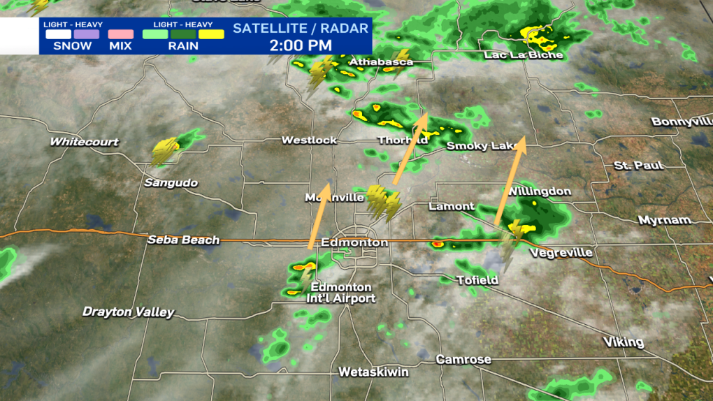
The worst of the storm is moving out of the NE end of Edmonton. Fort Saskatchewan and area are next in line for the torrential downpours.
If you live in south Edmonton, you were mostly missed by the storm, with only a few spots getting some rain. The severe thunderstorm warning for the city of Edmonton will likely be ended soon.

Josh Classen at 9:00 p.m.:
As the storm rips across Edmonton, most areas are just getting torrential downpours and some wind. A few areas are reporting small pea-sized hail. AND...it probably won't get more severe than that. Again, it's still looking like most areas should get about 30 min of nasty weather before conditions improve.
Josh Classen at 8:45 p.m.:
Storm will push across the city of Edmonton with heavy rain, strong wind gusts and possibly some pockets of hail. Most areas will only get intense rainfall. The storm should last for approximately 30 min for any given area, although it may not rain AS HEAVILY for that entire duration.
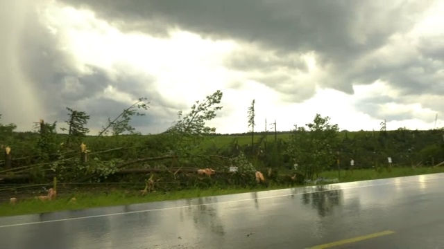
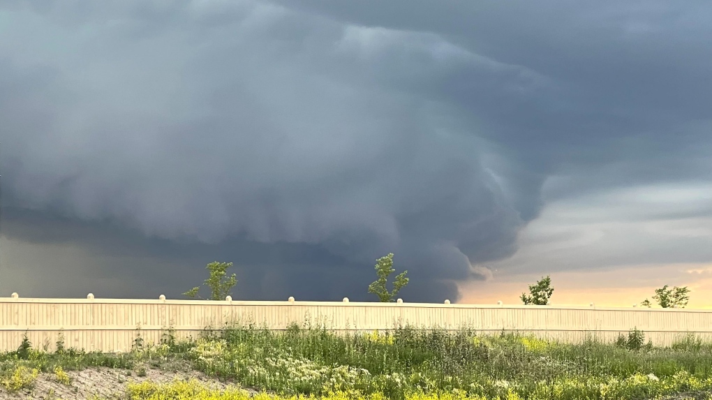 A storm cell moves toward north Edmonton on Thursday, July 7, 2022 (CTV News Edmonton/Sean McClune).
Josh Classen at 8:30 p.m.:
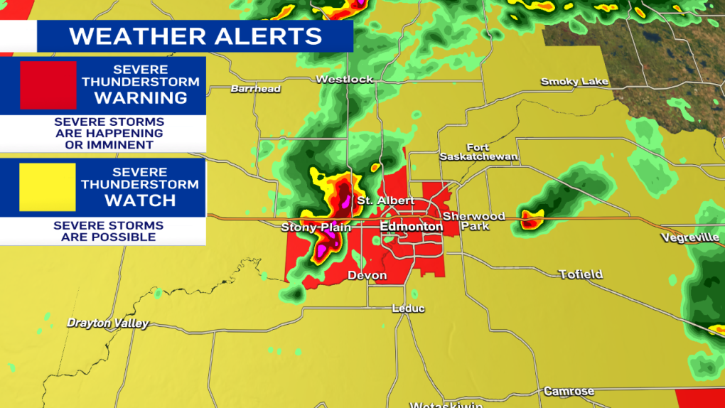
The city of Edmonton and surrounding areas are now under a Severe Thunderstorm WARNING. The storms are moving ENE at approx 30 km/h. Torrential downpours are the primary threat, along with strong wind gusts. Pockets of hail are possible as well.
Josh Classen at 8:05 p.m.:
Severe storms in the Stony Plain/Spruce Grove region are moving ENE at about 30 km/h.
These storms are capable of producing toonie to ping pong ball-sized hail, downpours and strong wind gusts. It is likely that at least western and northwestern parts of Edmonton will get hit by these storms over the course of the next hour or two.

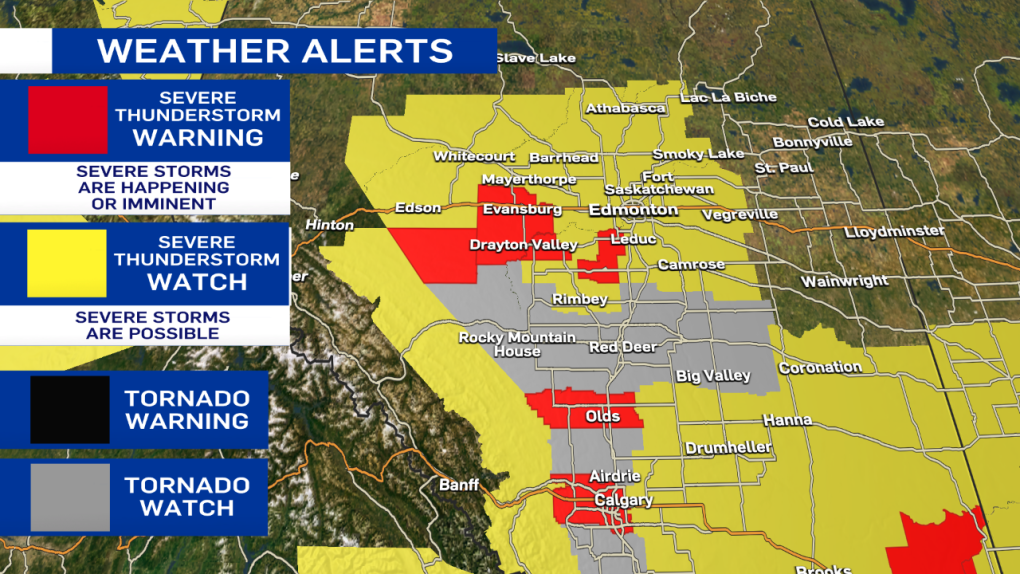
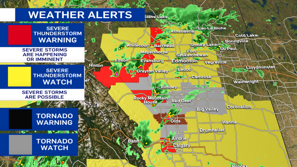
Also - here's the latest on the severe weather alerts. All of the tornado watches have been ended. Severe thunderstorm warnings and watches remain in effect.
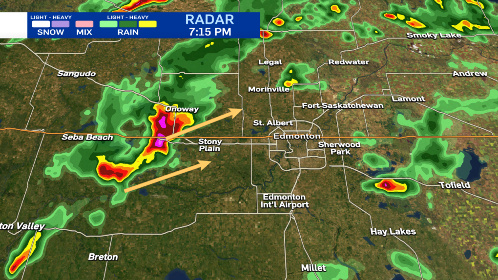
Josh Classen at 7:15 p.m.:
A severe storm just west of Stony Plain is slowly tracking northeast. Toonie to ping pong ball-sized hail, heavy rain and strong wind gusts are the main threats. That storm is part of a broken line of showers and storms heading NE. The nastiest storm (pink cell in the radar image) will likely miss the city (or at least the vast majority of it. But, Stony Plain and areas just north and NW of Edmonton could be in for quite the storm over the next few hours.
The concern for the city of Edmonton is the southern edge of that line. As it gradually inches further east, there is still the potential it could move into the city later this evening.
So...as I said at 6:30 - there's no imminent threat of a storm over the city. But, we're still not completely "out of the woods."
I'll continue to monitor the situation and send another update in an hour or so.
Josh Classen at 6:30 p.m.:
Thunderstorms continue to hit some areas SE of Edmonton and to the west near Lake Wabamun. However, aside from a few scattered showers, the city has been missed and MIGHT get missed altogether.
A severe thunderstorm WATCH remains in effect. However, the risk looks much lower than just an hour or two ago. IF we're going to get anything, it'll be later this evening as the line of storms from Drayton Valley to Onoway moves ENE. It appears that may slip past the city, though. We'll continue to monitor the situation. But, there is no imminent threat of severe weather at this point.
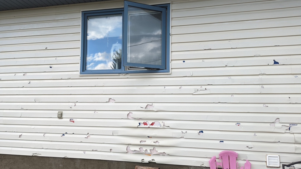 Hail damage after ping pong to golf ball sized hail hit Oyen, Alta., on Thursday, July 7, 2022 (Source: Tracy Hudson).
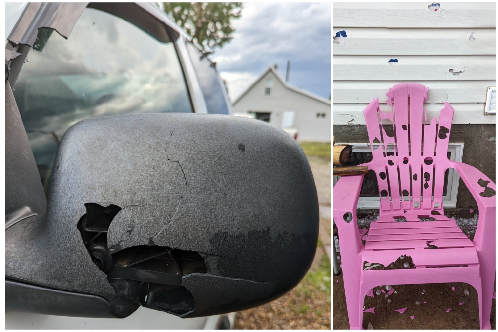 Hail damage after ping pong to golf ball sized hail hit Oyen, Alta., on Thursday, July 7, 2022 (Source: Tracy Hudson).
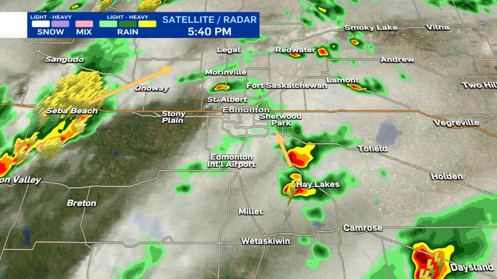
Josh Classen at 5:40 p.m.:
A severe thunderstorm WATCH remains in effect for the city of Edmonton. Right now, the storms "of concern" are just SE of the city and seem to be spinning back towards the NNW, potentially getting closer to Edmonton over the next hour. Those two storms near Hay Lakes are not severe as of now but may be producing some small hail and are definitely dropping heavy rain.
The severe storms near Seba Beach will slowly move NE, and most of that should pass north of Edmonton.
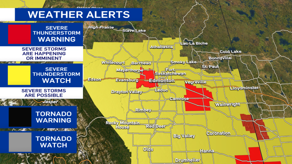
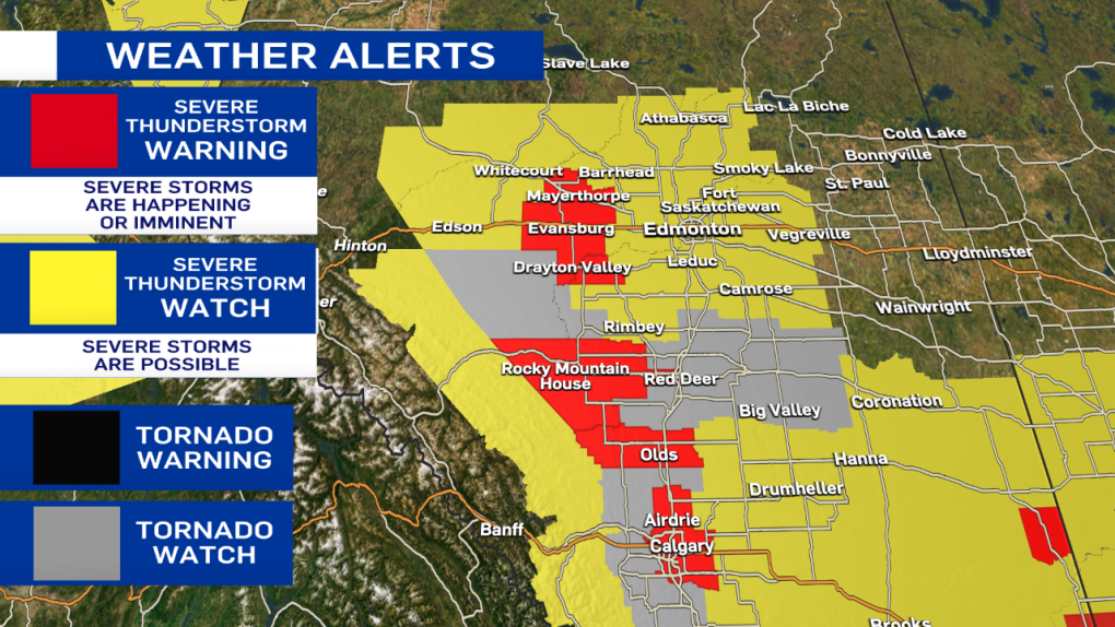
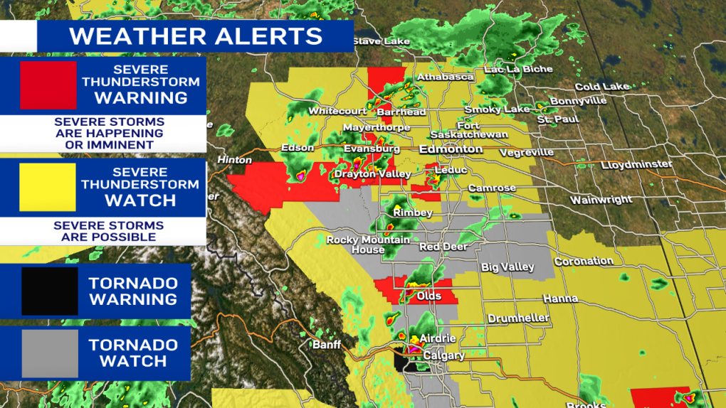
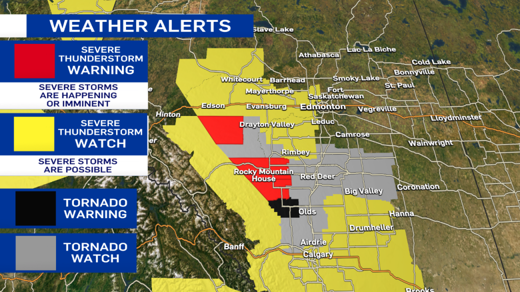
Here are the latest advisories, including Tornado WATCHes for the areas in grey (including Red Deer and Calgary).
Josh Classen at 4:55 p.m.:
The tornado warning for areas just west of Calgary has ENDED and has been replaced by a severe thunderstorm WARNING.
Isolated storms continue to close in on the Edmonton region and surrounding areas with the threat of severe storms continuing through this evening.
RCMP confirm to CTV News that the storm damaged approximately six to nine homes. Officers from Olds, Sundre, and Didsbury deployed to check on area residents, with everyone accounted for.
 Damage visible east of Bergen, Alta., after a storm that produced a tornado on Thursday, July 7, 2022 (CTV News/Nav Sangha).
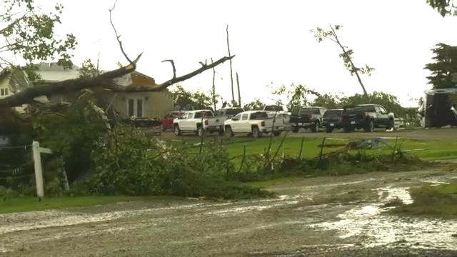 Damage visible east of Bergen, Alta., after a storm that produced a tornado on Thursday, July 7, 2022 (CTV News/Nav Sangha).
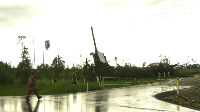 Damage visible east of Bergen, Alta., after a storm that produced a tornado on Thursday, July 7, 2022 (CTV News/Nav Sangha).
Josh Classen at 4:35 p.m.:
A tornado WARNING has been issued for a storm just northwest of Calgary. The storm may be producing a tornado and is 15 km south of Cochrane, heading east at 20 km/h.
The storm that I mentioned earlier (west of Millet) has now been upgraded to a severe thunderstorm WARNING as it is likely producing up to toonie-sized hail and heavy downpours. That storm is moving north at 20 km/h towards Devon and the Edmonton region.
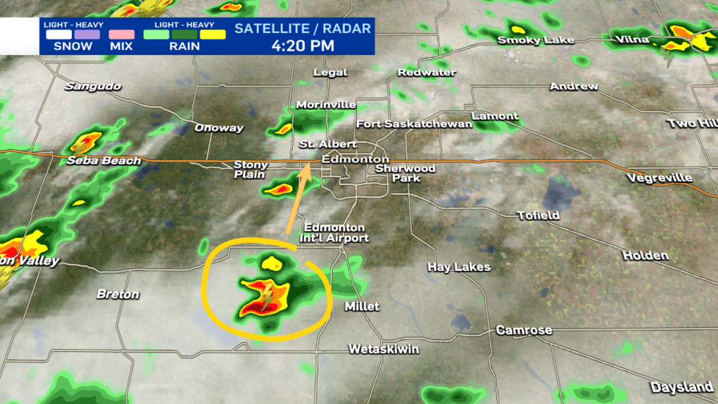
Josh Classen at 4:20 p.m.:
It's still a non-severe storm. But, we're keeping an eye on this cell west of Millet heading north towards the west end of the Edmonton region. We'll have more on all of this activity on CTV News Edmonton tonight at 5, 6 & late night at 11:30 p.m.
Josh Classen at 3:55 p.m.:
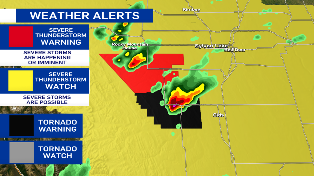
A severe thunderstorm WARNING has been issued for a storm west of Drayton Valley heading towards Drayton Valley. It is likely producing hail, as well as heavy downpours. Radar indicates this storm may also be possible of producing a tornado.
Another storm further west is has also turned severe with large hail likely.
The tornado warning has ENDED for the storm south of Sundre although that area just west of Olds continues to get pummeled with heavy rain and likely hail. The area is now under a severe thunderstorm WARNING.
Josh Classen at 3:30 p.m.:
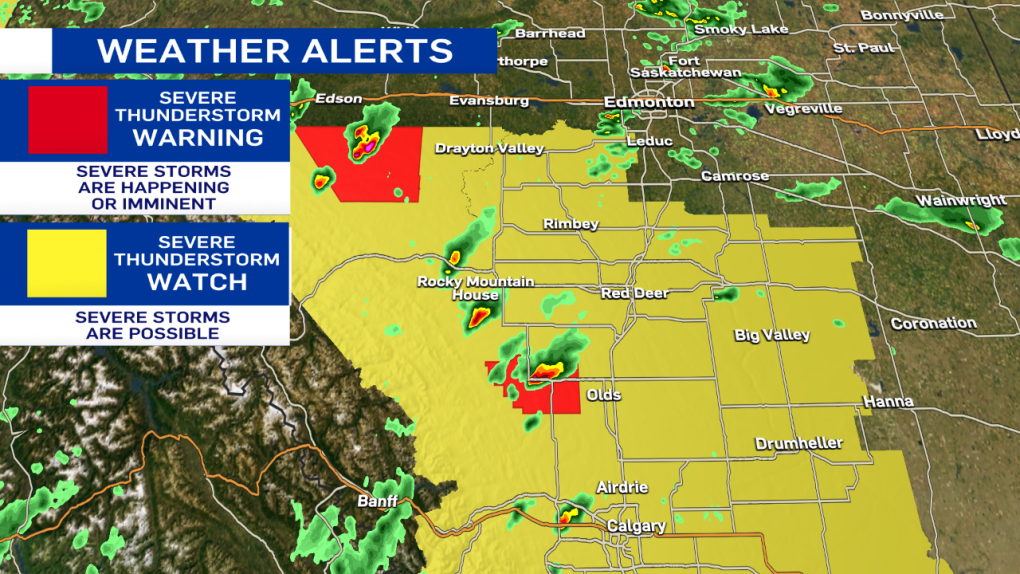
A Severe thunderstorm WATCH is now in effect for the City of Edmonton and regions to the north towards Athabasca and east towards Vegreville. This alert area will likely continue to be expanded further east this evening.
A WATCH means there is the potential for storms to turn severe. However, it remains important to note that most areas within that "watch zone" will not get severe weather. At this point, we don't have exact timing or location details for storms within the WATCH.
Severe Thunderstorm WARNINGs remains in effect for storms south of Edson, near Rocky Mountain House and just NW of Barrhead. All of those storms are moving NE and producing heavy downpours as well as hail.
A Tornado WARNING remains in effect for areas SE of Sundre (where there has already been a tornado).
A Tornado WATCH remains in effect for the areas in grey on the map including the city of Red Deer.
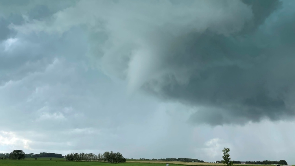 A funnel cloud appears northwest of Didsbury, Alta., around 3:30 p.m. (Source: Braydon Morisseau/Prairie Storm Chasers).
Josh Classen at 3 p.m.:
A tornado WATCH is in effect for the areas in grey on the map. This means conditions are favourable for the development of severe thunderstorms that might produce a tornado.
A tornado WARNING remains in effect for a storm about 10 km south of Sundre. A tornado has been spotted near Bergen, and the storm is slowly moving ENE but remains a long way away from the QE2.
*** It's important to remember that most areas under a WATCH will not see any severe weather, but have the POTENTIAL for severe storms. Be aware of your surroundings, and stay tuned to weather alerts as they develop. The main threat of severe weather remains over areas south of the Edmonton region. The city sits on the northern end of the risk zone, and while severe storms are possible, they are far from guaranteed.
Josh Classen at 2:37 p.m.:
A tornado WARNING has been issued for areas near Sundre, and storm-chaser Kyle Brittain is in the area reporting a tornado touchdown near Bergen, just south of Sundre. The storm is SLOWLY moving NNE. People in that area should immediately seek shelter.
Josh Classen at 2:30 p.m.:
The Severe Thunderstorm WATCH area has extended further north to include Whitecourt/Mayerthorpe, Edson, Evansburg and areas just west of Edmonton, including Stony Plain and Spruce Grove. The city of Edmonton still isn't under an advisory. But, that may change later this afternoon as the storms continue to develop.
Josh Classen at 2:15 p.m.:
A small non-severe thunderstorm SW of Edmonton is moving NNE and should slide through western parts of the Edmonton metro region. The primary risk for powerful and possibly severe storms remains late this afternoon and early this evening.

A severe storm has developed west of Olds and is moving NE toward Bowden and Innisfail. Heavy rain and large hail are the main threats from this storm cell.
Another severe storm south of Edson is also likely producing hail as well as heavy downpours. This storm is moving also moving NE.
Cory Edel at 11:45 a.m.:
A Severe Thunderstorm Watch has now been issued by Environment Canada for areas just south and southwest of Edmonton.
Drayton Valley and Wetaskiwin are included in this watch area which extends south to the U.S. border. Conditions continue to ripen, with severe thunderstorms becoming more likely as we get into the late afternoon and evening.
Although Edmonton is not included in the Severe Thunderstorm Watch, that could change as storms start to develop and storm threat and path becomes clearer.
Remember, the dangers of severe thunderstorms include lightning, strong damaging winds and hail, along with heavy localized rain. In extreme cases, severe thunderstorms can produce tornadoes. If you find yourself in a situation with large storm clouds moving in, best to head inside until they pass through the area.
There is a saying, "When thunder roars, go indoors," a reminder that conditions could be changing quite quickly. Stay informed with us as we continue to follow this developing weather situation over Edmonton and central Alberta.
Cory Edel at 8 a.m.:
We're kicking off this Thursday with sun and cloud, seemingly quiet, but there is a good chance that will change as we head into the afternoon.
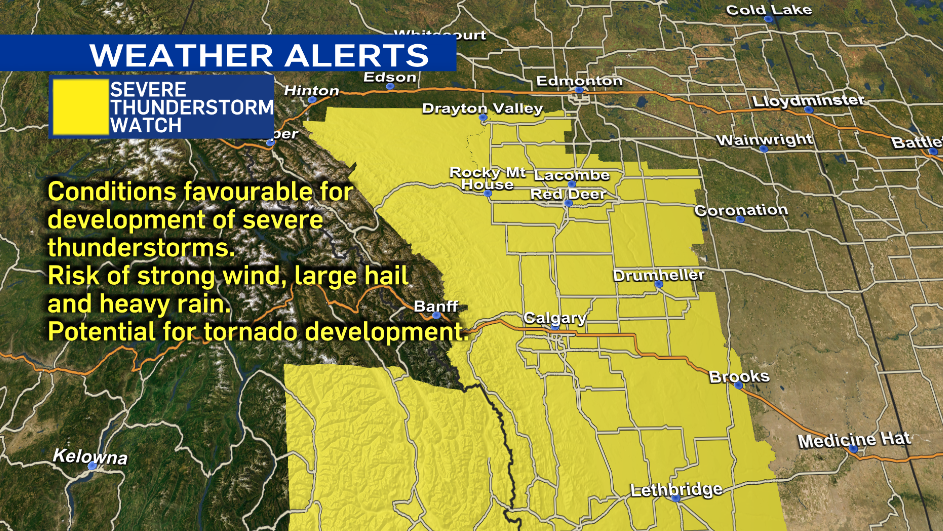
Today's weather conditions are favourable for the development of potentially severe thunderstorms through central areas of Alberta, including Edmonton.
These storms could produce large hail, strong wind and localized heavy rainfall.
With severe thunderstorms, there is also potential for tornado development. These storm cells could see some good rotation, and with that rotation and low level shear, the risk for tornadoes will be present later today. The greatest risk for this is south of the city, as Edmonton will be on the north-eastern edge of the severe storm risk area.
As far as timing, we will start to see some of these storms kick up off the foothills and pull to the northeast through the afternoon. For Edmonton, it's looking like we see the risk of the storms around the supper hour into the mid evening, about 5 p.m. to 9 p.m. If you are heading to the Edmonton Elks game tonight or have outdoor activities planned, it will be a good idea to be prepared to change your plans with this potentially fast-changing weather.
The storms will likely continue to pull to the east and northeast areas of the province later tonight and into the early morning hours. We will be keeping an eye on this developing severe-weather situation and follow up with any severe thunderstorm and possible tornado warnings issued by Environment Canada.
Join us on CTV News at 5 and 6 with Josh Classen as he tracks the development of these storms.


CTVNews.ca Top Stories

Young people 'tortured' if stolen vehicle operations fail, Montreal police tell MPs
One day after a Montreal police officer fired gunshots at a suspect in a stolen vehicle, senior officers were telling parliamentarians that organized crime groups are recruiting people as young as 15 in the city to steal cars so that they can be shipped overseas.
Man sets self on fire outside New York court where Trump trial underway
A man set himself on fire on Friday outside the New York courthouse where Donald Trump's historic hush-money trial was taking place as jury selection wrapped up, but officials said he did not appear to have been targeting Trump.
Sask. father found guilty of withholding daughter to prevent her from getting COVID-19 vaccine
Michael Gordon Jackson, a Saskatchewan man accused of abducting his daughter to prevent her from getting a COVID-19 vaccine, has been found guilty for contravention of a custody order.
Mandisa, Grammy award-winning 'American Idol' alum, dead at 47
Soulful gospel artist Mandisa, a Grammy-winning singer who got her start as a contestant on 'American Idol' in 2006, has died, according to a statement on her verified social media. She was 47.
She set out to find a husband in a year. Then she matched with a guy on a dating app on the other side of the world
Scottish comedian Samantha Hannah was working on a comedy show about finding a husband when Toby Hunter came into her life. What happened next surprised them both.
'It was joy': Trapped B.C. orca calf eats seal meat, putting rescue on hold
A rescue operation for an orca calf trapped in a remote tidal lagoon off Vancouver Island has been put on hold after it started eating seal meat thrown in the water for what is believed to be the first time.
B.C. judge orders shared dog custody for exes who both 'clearly love Stella'
In a first-of-its-kind ruling, a B.C. judge has awarded a former couple joint custody of their dog.
Shivering for health: The myths and truths of ice baths explained
In a climate of social media-endorsed wellness rituals, plunging into cold water has promised to aid muscle recovery, enhance mental health and support immune system function. But the evidence of such benefits sits on thin ice, according to researchers.
'It could be catastrophic': Woman says natural supplement contained hidden painkiller drug
A Manitoba woman thought she found a miracle natural supplement, but said a hidden ingredient wreaked havoc on her health.
Shopping Trends
The Shopping Trends team is independent of the journalists at CTV News. We may earn a commission when you use our links to shop. Read about us.


Calgary
-

From 'barely surviving, to living': Calgary family champions local mental health supports
It seemed like their world was crashing in when free mental health services changed the lives of a Calgary family and now they are trying to help others get the same support.
-
B-Boy and B-Girls descend on Calgary for Red Bull BC One qualifying event
A pair of Calgary dancers are among the B-Boys and B-Girls in town to compete in a Red Bull BC one qualifying event Saturday night.
-
Calgary man accused in toddler death released on bail
Winston Campbell granted bail at first court appearance
Lethbridge
-

Lethbridge cutting back on water use as part of provincial water sharing agreement
The province has announced the largest water sharing agreement in Alberta’s history, which will see Lethbridge and Medicine Hat, among other municipalities, cut water use.
-
Medicine Hat woman charged after $60K stolen from Redcliff Legion
Mounties say a 32-year-old Medicine Hat woman has been charged in connection with the theft of $60,000 from the Redcliff Legion.
-
Deterrent sentence possible, expert says, after trio convicted in connection to Coutts border blockade
Three men who helped lead and co-ordinate the 2022 border blockade at Coutts, Alta., have been found guilty of public mischief.
Saskatoon
-

‘My family are all broken-hearted’: Grandfather of homicide victim speaks out
Saskatoon is grappling with the tragic death of 24-year-old Melissa Duquette, whose body was discovered on April 15. A day later, authorities confirmed her death as a homicide, sparking deep sorrow and calls for action within the community.
-
Saskatoon judge to make ruling on evidence in fatal THC-impaired driving case
A Saskatoon Provincial Court judge will determine whether testimony from a woman, charged with impaired driving causing the death of a child, will be used as evidence in her trial.
-
Sask. Teachers' Federation sending offer to a vote 'tactical move': labour scholar
Teachers have three weeks to consider how they’ll vote on an offer from the provincial bargaining committee. But where does the dispute go next?
Regina
-

Sask. father found guilty of withholding daughter to prevent her from getting COVID-19 vaccine
Michael Gordon Jackson, a Saskatchewan man accused of abducting his daughter to prevent her from getting a COVID-19 vaccine, has been found guilty for contravention of a custody order.
-
Sask. Teachers' Federation sending offer to a vote 'tactical move': labour scholar
Teachers have three weeks to consider how they’ll vote on an offer from the provincial bargaining committee. But where does the dispute go next?
-
Saskatoon police to search landfill for remains of woman missing since 2020
Saskatoon police say they will begin searching the city’s landfill for the remains of Mackenzie Lee Trottier, who has been missing for more than three years.
Vancouver
-

B.C. judge orders shared dog custody for exes who both 'clearly love Stella'
In a first-of-its-kind ruling, a B.C. judge has awarded a former couple joint custody of their dog.
-
Home sale contract handwritten in Chinese holds up in B.C. court
A one-page contract for the purchase of a B.C. home that was handwritten in Chinese has been deemed valid in the province's Supreme Court, leaving the would-be buyer on the hook for more than $400,000.
-
B.C. student among hundreds of false winners of Tim Hortons contest
Since moving to B.C. from Colombia to go to university, Marylin Moreno has been a regular at Tim Hortons – and she always scans her app so she can play the iconic Roll Up To Win contest.
Vancouver Island
-

'It was joy': Trapped B.C. orca calf eats seal meat, putting rescue on hold
A rescue operation for an orca calf trapped in a remote tidal lagoon off Vancouver Island has been put on hold after it started eating seal meat thrown in the water for what is believed to be the first time.
-
After breaking world records and training movie stars, B.C. free diver becomes police dispatcher
For as long as Mandy-Rae Krack can recall, the water has inspired wonder.
-
Mounties arrest 7 after 'significant' seizure of drugs, guns on Vancouver Island
Mounties say seven people have been arrested after a series of co-ordinated property searches on Vancouver Island yielded multiple firearms, including 3D-printed handguns, and several kilograms of drugs.
Toronto
-

Ontario early childhood educators still waiting for promised 2024 wage increases
Ontario Registered Early Childhood Educators (RECEs) are still waiting for their promised 2024 wage increases and advocates say the delay is causing stress for workers.
-
U.S. FAA launches investigation into unauthorized personnel in cockpit of Colorado Rockies flight to Toronto
The U.S.’s Federal Aviation Administration is investigating a video that appears to show unauthorized personnel in the cockpit of a charted Colorado Rockies flight to Toronto.
-
WATCH
WATCH Video shows dramatic police takedown of carjacking suspects chased through parking lot north of Toronto
Police have released video footage of a dramatic takedown of a group of teens wanted in connection with an attempted carjacking in Markham earlier this month.
Montreal
-
Young people 'tortured' if stolen vehicle operations fail, Montreal police tell MPs
One day after a Montreal police officer fired gunshots at a suspect in a stolen vehicle, senior officers were telling parliamentarians that organized crime groups are recruiting people as young as 15 in the city to steal cars so that they can be shipped overseas.
-
Woman stabbed at motel in Montreal's west end
A 39-year-old woman was sent to hospital with serious injuries after police say she was stabbed inside a motel room in Montreal's west end Friday morning.
-
Iconic ninth floor Eaton Centre restaurant set to reopen in May
There was once a beautiful restaurant on the ninth floor of the former Eaton's department store. It closed 25 years ago, but many in Montreal still talk about it. Soon, Le 9ieme will open to diners once again.
Atlantic
-

Nova Scotia justice minister resigns following domestic violence comments
Nova Scotia Justice Minister Brad Johns has resigned, according to a short statement from Premier Tim Houston on Friday evening.
-
Lyrid meteor shower nears peak; viewing opportunities in the Maritimes
CTV Atlantic meteorologist Kalin Mitchell says a large part of the Maritimes should have ideal viewing conditions for the Lyrid meteor shower Sunday overnight into Monday morning.
-
N.B. Environment Minister Gary Crossman resigns, says political beliefs 'no longer align' with Higgs’ government
Gary Crossman, New Brunswick’s minister of environment and climate change, has resigned from Blaine Higgs’ Progressive Conservative cabinet effective immediately.
Winnipeg
-

'Like part of the family': St. Boniface burger staple back after closing down last year
Mrs. Mikes shut down last year after a half-century of serving the community. Now its doors have reopened and Winnipeggers were lined up to get their fill, even as snow fell on them.
-
Winnipeg airport's longest runway is getting a facelift
The Winnipeg Airports Authority is doing an extensive repaving project to its largest runway.
-
Manitoba mom praises quick-thinking fire department for freeing daughter stuck in playground equipment
A Manitoba mother is praising firefighters for their quick work in helping her daughter who got stuck at a playground in Lorette, Man.
Ottawa
-

Tenants fighting proposed redevelopment in Centretown
As the City of Ottawa faces a housing shortage, there is controversy brewing in Centretown over a proposed redevelopment that many tenants say could leave them homeless.
-
Tropical fish stolen from Beachburg, Ont. restaurant found and returned
Ontario Provincial Police have landed a suspect following a fishy theft in Beachburg, Ont.
-
Will parking remain free in Wellington West and Westboro? City studying parking options
Time could soon run out on free on-street parking in Ottawa's Westboro, Wellington West and Hintonburg neighbourhoods.
Northern Ontario
-

Vicious attack on a dog ends with charges for northern Ont. suspect
Police in Sault Ste. Marie charged a 22-year-old man with animal cruelty following an attack on a dog Thursday morning.
-
Man sets self on fire outside New York court where Trump trial underway
A man set himself on fire on Friday outside the New York courthouse where Donald Trump's historic hush-money trial was taking place as jury selection wrapped up, but officials said he did not appear to have been targeting Trump.
-
Flood warning issued for Lake Nipissing shoreline in North Bay
A flood warning was issued Friday for the Lake Nipissing shoreline in North Bay, Callander and the Parks Creek watershed.
Barrie
-

Driver charged after Highway 400 crash sends woman and child to hospital
One person has been charged following a collision on Highway 400 in Barrie Friday morning that sent a vehicle rolling into a ditch.
-
Barrie pharmacy launches 1st provincial pharmacist care walk-in clinic
The first provincial pharmacist care walk-in clinic has opened at the Rexall in the north end of Barrie to provide more immediate care for minor illnesses and chronic care in a more private setting.
-
Break-in leaves Barrie home with considerable water damage
Police are hoping to identify the person(s) who allegedly broke into a Barrie home and caused extensive water damage.
Kitchener
-

NDP leader likens Wilmot farmland grab to Greenbelt scandal
A controversial land acquisition proposed in Wilmot Township is once again in the spotlight, as Ontario NDP leader Marit Stiles hosts a town hall in the community, calling the deal “eerily similar” to the Greenbelt scandal.
-
'I'm still shaking': Emotional victim impact statements shared after impaired double-fatal crash in Cambridge
It was an emotional day in court as close to a dozen people read victim impact statements to the man charged with impaired driving in a double-fatal Cambridge crash.
-
Kitchener golfer recognized as creator of Masters skip-shot tradition
A Canadian Hall of Fame golfer from Kitchener is finally getting recognition for starting the skip-shot tradition at The Masters.
London
-

No more train trauma for Adelaide Street commuters
‘Onto Adelaide and just zip down’: Cars no longer have to deal with trains on Adelaide Street North, near Central Avenue.
-
Witness insists they are telling the truth at sexual abuse trial
A witness at the sexual assault trial involving parents is adamant the children involved in the trial are all telling the truth about what they had to endure during their upbringing.
-
City councillor says encampment response falls short and comes too late
A city councillor said she’s concerned the city is encouraging homeless encampments rather than finding more permanent solutions.
Windsor
-

'My family’s suffering still hasn’t ended': Faint hope hearing evidence concludes with victim impact statements
A Windsor man convicted in a violent murder 20 years ago awaits ruling on bid for early parole.
-
Body recovered from Detroit River
An investigation is underway after a body was pulled from the Detroit River.
-
One driver charged, one sought after crash at apparent 'unsanctioned' rally
Windsor police have charged a 21-year-old man with stunt driving following a collision at a commercial property.


