Thunderstorm rolls through Edmonton area Saturday morning, potential for more storms later
EDMONTON -
A storm system rolled through the capital region Saturday morning as the risk for more thunderstorms continues.
Small hail, rain, and winds blasted Edmonton as the brief storm moved through after 10 a.m.
According to Environment Canada, the international airport registered winds up 17 km/h with gusts up to 30 km/h during the storm.
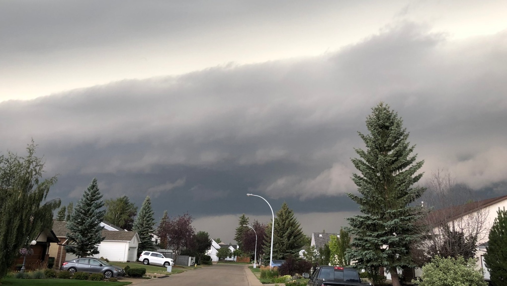 Storm clouds loom over Edmonton on Saturday, August 7, 2021 (Source: Kathy Reid)
Storm clouds loom over Edmonton on Saturday, August 7, 2021 (Source: Kathy Reid)
The City of Edmonton’s rainfall totals and storm severity ratings showed that most areas received between 10 to 20 millimetres of rain during the brief storm, with the highest amounts registered in northeast parts of the city.
The 4th Street Promenade cancelled its downtown market on Saturday for the safety of patrons and vendors who were setting up just as the storm rolled through the city.
The Royal Alberta Museum said the rainy weather experienced earlier made for a perfect day to visit.
- Weather Blast with Meteorologist Josh Classen for August 6 and the weekend outlook
- 'That hit the stadium!': Videos show lightning strike near Edmonton Elks' stadium
- 'Boom!': Central Alberta woman catches nearby lightning strike on camera
THUNDERSTORM WATCH ISSUED FOR RED DEER AND EDMONTON
After the storm had passed and the sun came back into view, Environment Canada issued a thunderstorm watch for areas in central Alberta.
Edmonton, St. Albert, Sherwood Park, Drayton Valley, Pigeon Lake, Red Deer, Ponoka, and Stettler are included in the watch.
“Conditions are favourable for the development of severe thunderstorms that may be capable of producing strong wind gusts, large hail and heavy rain,” the weather watch said.
"Severe thunderstorms have developed in central Alberta, and are tracking to the east. The thunderstorms are expected to weaken and become non-severe later this evening."
Environment Canada issues watches when conditions indicate the potential for severe weather to occur.
The Prairie and Arctic Storm Prediction Centre said in its thunderstorm outlook on Saturday that the highest risk area for potential thunderstorm development in the afternoon would be across central and north-central Alberta.
“These storms are likely to continue into the overnight hours and track through northern Saskatchewan.”
According to the thunderstorm outlook, the potential storms could generate two to four centimetre sized hail and possible wind gusts of 90 km/h.


CTVNews.ca Top Stories

Quebec nurse had to clean up after husband's death in Montreal hospital
On a night she should have been mourning, a nurse from Quebec's Laurentians region says she was forced to clean up her husband after he died at a hospital in Montreal.
Northern Ont. lawyer who abandoned clients in child protection cases disbarred
A North Bay, Ont., lawyer who abandoned 15 clients – many of them child protection cases – has lost his licence to practise law.
Bank of Canada officials split on when to start cutting interest rates
Members of the Bank of Canada's governing council were split on how long the central bank should wait before it starts cutting interest rates when they met earlier this month.
Maple Leafs fall to Bruins in Game 3, trail series 2-1
Brad Marchand scored twice, including the winner in the third period, and added an assist as the Boston Bruins downed the Toronto Maple Leafs 4-2 to take a 2-1 lead in their first-round playoff series Wednesday
Cuban government apologizes to Montreal-area family after delivering wrong body
Cuba's foreign affairs minister has apologized to a Montreal-area family after they were sent the wrong body following the death of a loved one.
'It was instant karma': Viral video captures failed theft attempt in Nanaimo, B.C.
Mounties in Nanaimo, B.C., say two late-night revellers are lucky their allegedly drunken antics weren't reported to police after security cameras captured the men trying to steal a heavy sign from a downtown business.
What is changing about Canada's capital gains tax and how does it impact me?
The federal government's proposed change to capital gains taxation is expected to increase taxes on investments and mainly affect wealthy Canadians and businesses. Here's what you need to know about the move.
New Indigenous loan guarantee program a 'really big deal,' Freeland says at Toronto conference
Canada's Deputy Prime Minister Chrystia Freeland was among the 1,700 delegates attending the two-day First Nations Major Projects Coalition (FNMPC) conference that concluded Tuesday in Toronto.
'Life was not fair to him': Daughter of N.B. man exonerated of murder remembers him as a kind soul
The daughter of a New Brunswick man recently exonerated from murder, is remembering her father as somebody who, despite a wrongful conviction, never became bitter or angry.
Shopping Trends
The Shopping Trends team is independent of the journalists at CTV News. We may earn a commission when you use our links to shop. Read about us.


Calgary
-

Coyote calls on the rise in Calgary; city wildlife team advises caution
The City of Calgary's wildlife team says they're fielding hundreds of calls about coyotes.
-
Mounties respond to serious crash near Okotoks, Alta.
A serious vehicle collision near Okotoks, Alta., shut down roadways on Wednesday evening.
-
Auburn Bay community members rally around grieving widow, three young children
Residents of one southeast Calgary neighbourhood have raised thousands of dollars to support a family grieving the losses of a father and grandfather.
Lethbridge
-
Fire risk for southern Alberta high: Natural Resources Canada
It’s not even May 1 and the fire risk for southern Alberta is already alarming.
-
Lethbridge’s Whoop-Up Days accepting applications to be in 2024 parade
Whoop-Up Days is still four months away, but applications to be in this year’s parade are now open.
-
Lethbridge added 28 physicians over the past year, AHS continues search for more
Lethbridge has added 28 physicians over the past year, according to a quarterly report published by the College of Physicians and Surgeons of Alberta.
Saskatoon
-

This Saskatchewan woman is helping fill bellies and hearts with a free grocery store
Darlene Hartshorn is a mother and grandmother from Warman who is making a difference by helping those who need a hand up.
-
Sask. woman fights to find out who had her apprehended for a psych. assessment
A Saskatchewan woman who was taken for an involuntary mental health assessment is entitled to find out who had her committed, a provincial court judge has ruled.
-
Boeing invests $17 million in Sask. aviation program
International aircraft giant Boeing has made a multi-million dollar commitment to the Saskatchewan Indian Institute of Technology (SIIT) to help address shortages in the aviation industry.
Regina
-

Revitalization of Regina's Dewdney Avenue to begin next week
Beginning April 29, Dewdney Avenue between Albert Street and Broad Street will see a number of construction sites.
-
'Learn to walk again': Sask. doctor tells story of miracle recovery from deadly heart condition
It was a powerful morning at Regina's Conexus Arts Centre Wednesday, where the Lieutenant Governor hosted the annual Saskatchewan Prayer Breakfast and a provincial doctor told his story of survival from a deadly heart condition.
-
Throwing star, crossbow found during Sask. RCMP searches at George Gordon FN, Punnichy
A throwing star and crossbow were among the seizures by police as part of a drug trafficking investigation on George Gordon First Nation and in Punnichy, Sask. last week.
Vancouver
-

'Enjoy the run' but don’t expect major economic boost from Canucks playoffs: expert
A Canadian sports economist is encouraging Canucks fans to enjoy the team’s playoff run, but cautioning against having big expectations around economic spinoffs.
-
'A bad welcome': B.C. stabbing victim is new to Canada, wife says
The man who was stabbed by a stranger on the White Rock Pier last weekend is new to Canada, according to his wife.
-
'Tactical evacuation' underway near Chetwynd, B.C., due to out-of-control wildfire
Police and firefighters are going door-to-door telling people who live in the vicinity of a wildfire burning out of control near Chetwynd they need to evacuate.
Vancouver Island
-

'It was instant karma': Viral video captures failed theft attempt in Nanaimo, B.C.
Mounties in Nanaimo, B.C., say two late-night revellers are lucky their allegedly drunken antics weren't reported to police after security cameras captured the men trying to steal a heavy sign from a downtown business.
-
Woman who killed Reena Virk calls new TV series disrespectful to victim
The B.C. woman convicted of killing Reena Virk described the TV series dramatizing the notorious 1997 murder as disrespectful to the victim and her family.
-
RCMP officers 'refused' to provide evidence to Crown to assist drug, firearms prosecution: report
Crown counsel was unable to approve "significant" drug and weapons charges stemming from an arrest in Quesnel, B.C., last year because the officers involved "refused to provide any evidence," according to a report from the province’s police watchdog.
Toronto
-

An Ont. township has been without a full supermarket for nearly a year. Residents just learned it won't reopen
A township east of Toronto has been without its only full supermarket for nearly a year after it was destroyed in a fire. On Tuesday, residents learned it won't reopen.
-
Delivery truck driver dead after collision at industrial complex in Mississauga
A delivery truck driver is dead after a collision in an industrial complex in Mississauga Wednesday afternoon.
-
Maple Leafs fall to Bruins in Game 3, trail series 2-1
Brad Marchand scored twice, including the winner in the third period, and added an assist as the Boston Bruins downed the Toronto Maple Leafs 4-2 to take a 2-1 lead in their first-round playoff series Wednesday
Montreal
-
Quebec nurse had to clean up after husband's death in Montreal hospital
On a night she should have been mourning, a nurse from Quebec's Laurentians region says she was forced to clean up her husband after he died at a hospital in Montreal.
-
Woman, 37, dies after being hit by truck; police say driver could face impaired driving charges
A woman died after she was struck by a truck Wednesday afternoon in Montreal's Rivière-des-Prairies--Pointe-aux-Trembles borough.
-
REM delayed: Stations in West Island, North Shore now opening in 2025
Officials for Montreal's REM line confirmed that the lines to the West Island and the North Shore are being delayed and won't open until 2025.
Atlantic
-

A community in mourning: 16-year-old killed at Halifax parkade remembered
Community members gathered at a mosque for Ahmad Al Marrach — a 16-year-old murder victim — for his funeral on Wednesday.
-
N.S. man wins $1.5M through Atlantic Lottery
A Cape Breton man won $1.5 million after buying $200-worth of Atlantic Lottery Scratch’N Win tickets.
-
'Life was not fair to him': Daughter of N.B. man exonerated of murder remembers him as a kind soul
The daughter of a New Brunswick man recently exonerated from murder, is remembering her father as somebody who, despite a wrongful conviction, never became bitter or angry.
Winnipeg
-
'We are not here for tree preservation': Development company appealing latest decision with Lemay Forest
A new fight is gearing up at city hall over Lemay Forest.
-
'I just wanted to stand out': Winnipeg Jets fan goes viral for wearing salmon shirt at Whiteout
A Winnipeg Jets fan found a unique way to stand out amid the Winnipeg Whiteout; he wore a salmon-coloured shirt.
-
'We feel good about ourselves:' Jets coach Bowness optimistic after Game 2 loss
We feel good about ourselves and we feel we can go in there and win a game," Bowness said.
Ottawa
-
 NEW THIS MORNING
NEW THIS MORNING OCDSB program review aims to keep kids in schools closer to home, director says
The director of education for the Ottawa-Carleton District School Board says making sure elementary school students can attend classes close to home is an important part of making schooling in Ottawa more equitable.
-
NCC buys golf course near Gatineau Park for $3.9 million
The National Capital Commission has purchased the old Dunnderosa Golf Course in Chelsea, Que., as part of its plan to acquire private properties in Gatineau Park.
-
Can cars and bikes fit on the Queen Elizabeth Driveway and Colonel By Drive?
There are questions about how the National Capital Commission might fit bike lanes on the Queen Elizabeth Driveway and Colonel By Drive.
Northern Ontario
-

Northern Ont. lawyer who abandoned clients in child protection cases disbarred
A North Bay, Ont., lawyer who abandoned 15 clients – many of them child protection cases – has lost his licence to practise law.
-
Garden River chief meets with disgruntled band members over payout concerns
Some members of the Garden River First Nation are demanding answers regarding the disbursement of the Robinson-Huron Treaty settlement funds.
-
'My stomach dropped': Winnipeg man speaks out after being criminally harassed following single online date
A Winnipeg man said a single date gone wrong led to years of criminal harassment, false arrests, stress and depression.
Barrie
-

OPP confirm remains found are missing Thornbury man
OPP have confirmed that human remains found in Georgian Bay Township belong to 60-year-old Eric Spencer, who went missing in 2018.
-
Simcoe County Rovers FC make history in Toronto
It was a history-making night on Wednesday for Simcoe County Rovers FC, as the semi-pro team faced off against MLS team, Toronto FC.
-
U.S. Marshals join search for Wasaga Beach kidnapping suspect
U.S. Marshals joins search for Deshawn Davis, one of Canada’s most wanted, accused of the kidnapping of Elnaz Hajtamiri in Wasaga Beach January 2022 and the suspect in a nightclub shooting that took place in May of last year.
Kitchener
-

Ont. teacher says she's being forced to switch pharmacies to maintain medication coverage
A Waterloo, Ont. teacher says she’s frustrated after learning the arthritis medication she depends on is no longer covered under her benefits plan and she'll have to switch pharmacies to avoid paying out of pocket.
-
Film crew transforms Cambridge pizza shop
A Cambridge pizza restaurant got a temporary makeover this week, turning into a fictitious donut shop as part of a film production.
-
Pedestrian seriously hurt after crash in Kitchener
A pedestrian had to be taken to an out-of-region hospital following a crash in Kitchener.
London
-

Asylum claimants occupying 12% of London’s homeless shelter beds
In the midst of a homelessness crisis, an influx of asylum seekers is putting additional pressure on London, Ont.’s limited number of permanent shelter beds.
-
'You made me look for money while he bled on the floor': Man sentenced in manslaughter case nearly a decade after botched robbery
Nine years after a London, Ont. man was shot to death in a botched robbery at his home, the man responsible for the shooting was given a prison sentence on Wednesday.
-
Protest at shuttered auto parts maker over unpaid severance
Frustrated employees of Wescast’s shuttered auto parts manufacturer in Wingham, Ont. will be sending a message to their former ownership on Thursday.
Windsor
-

Convicted killer can ask for parole now: Windsor, Ont. jury accepts 'faint hope' application
A Windsor man convicted in a violent murder 20 years ago was successful in his ‘faint hope’ bid for an early chance at freedom after a jury agreed he should be given the chance to apply for early parole eligibility.
-
Honda expected to announce Ontario EV battery plant, part of a $15B investment
Prime Minister Justin Trudeau, Ontario Premier Doug Ford and Honda executives are expected to announce today that the Japanese automaker is building an electric vehicle battery plant in Alliston, Ont., part of a $15-billion investment.
-
Dandelions for daffodil month: Windsor-Essex craft brewers raise funds for Cancer Awareness Month
A Kingsville, Ont. brewer is dedicating sales of a special beer this month in honour of his late mother.


