

Here comes another snow and wind storm

Snow, gusty wind and then an arctic blast are on tap for central and northern Alberta this weekend.
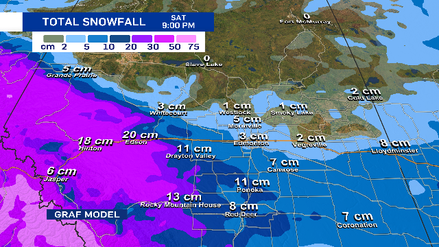
Edmonton and area will see most of its snowfall overnight Friday into early Saturday morning.
By midday or early Saturday afternoon, the snow should move off to the ESE.
Because the city's on the edge of the storm track, estimated snowfall totals are uncertain. However, 3 to 8 cm looks likely. If the system shifts further south, this may turn out to be more wind than snow.
BUT...if the track shifts further north, 10-ish centimetres isn't out of the question. Here's a look at the latest projected snowfall totals from the GRAF model.
We're far more certain about the wind. Northwesterlies as 20-30 km/h with gusts in the 40 to 50 km/h range will start early Saturday morning and continue through the afternoon.
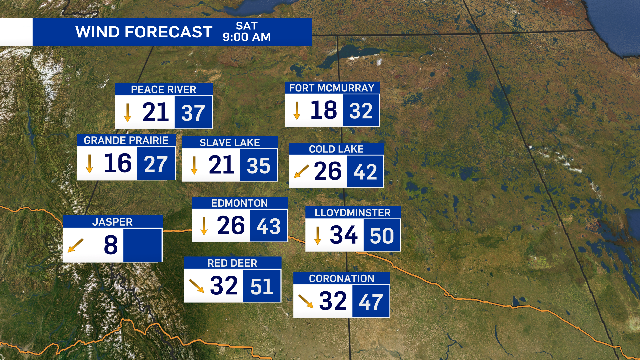
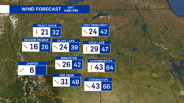
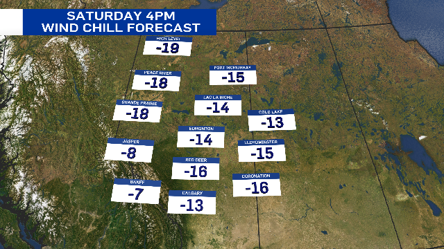
Blowing snow will significantly reduce visibility, especially on highways outside the city and with temperature falling through the day, wind chills will drop into the minus teens by Saturday afternoon.
Snowfall warnings are in effect for much of western Alberta from the Peace Country south to the U.S. border. Ten to 20 cm is likely through those regions.
As the system develops, more areas may be added to the warning zone.
Arctic air drops in on Saturday night and we start a string of days with highs in minus double digits on Sunday.
Looking further ahead, another storm system has the potential to produce heavy snow in southern and central Alberta on Monday.
It's early to be confident in snowfall estimates, but 5 to 10 cm looks possible for the Edmonton region.
Shopping Trends
The Shopping Trends team is independent of the journalists at CTV News. We may earn a commission when you use our links to shop. Read about us.


CTVNews.ca Top Stories

Possible scenarios that could play out in Ottawa as the Liberal government teeters
Prime Minister Justin Trudeau is said to be reflecting on his future over the holidays after the resignation of his top cabinet minister, Chrystia Freeland, in mid-December. The bombshell move prompted a fresh wave of calls for Trudeau to step down as Liberal leader from inside and outside the caucus.
5 things we know and still don't know about COVID, 5 years after it appeared
The virus is still with us, though humanity has built up immunity through vaccinations and infections. It's less deadly than it was in the pandemic's early days and it no longer tops the list of leading causes of death. But the virus is evolving, meaning scientists must track it closely.
Man who died in Tesla Cybertruck explosion was active-duty U.S. Army soldier, officials say
The person who authorities believe died in the explosion of a Tesla Cybertruck packed with firework mortars and camp fuel canisters outside U.S. president-elect Donald Trump's Las Vegas hotel was an active-duty U.S. Army soldier, three U.S. officials told The Associated Press on Thursday.
Woman, father killed on New Year's Eve were victims of intimate partner violence: Halifax police
Halifax police are investigating three deaths that are connected – two of which they say were homicides resulting from intimate partner violence – in the city on New Year’s Eve.
Mounties investigate discovery of 'very small pipe bomb' in Kamloops, B.C.
Mounties are investigating and appealing for witnesses after an explosive device was discovered Wednesday on a beach in Kamloops, B.C.
LIVE UPDATES
LIVE UPDATES FBI says the New Orleans truck attacker acted alone in an 'act of terrorism'
The FBI now says the New Orleans truck attacker acted alone in an 'act of terrorism' when he drove a pickup truck into a crowd of New Year's revellers early Wednesday, killing 14 people.
Sask. RCMP locate missing inmate of Yorkton prison
An inmate who was wanted for being unlawfully-at-large after not returning to Whitespruce Provincial Training Centre in Yorkton has been found and arrested.
FORECAST
FORECAST Weather warnings issued in 6 provinces and territories
Wintry weather conditions, including heavy snow and wind chill values around -55, prompted warnings in six provinces and territories early Thursday morning.
Who are Canada's top-earning CEOs and how much do they make?
Canada's 100 highest-paid CEOs earned $13.2 million on average in 2023 from salaries, bonuses and other compensation, according to the Canadian Centre for Policy Alternatives.
Calgary
-

Calgary army reservist and museum curator killed while ice climbing in B.C.
A Calgary army reserve officer was killed in an ice-climbing accident in eastern British Columbia over the holidays.
-
Marathon rezoning meeting and transit troubles among Calgary City Hall's biggest stories of 2024
Calgary’s city council had a busy year in 2024, contending with backlash over bag fees, a marathon debate about city-wide rezoning, broken water mains and a stop-and-go process with the Green Line LRT project.
-
'It's just unbelievable': Calgary-based band performs in front of thousands in iconic Rose Parade
A Calgary-based band travelled to Pasadena, Calif., to play in the 136th Rose Parade on New Year’s Day.
Lethbridge
-

2 charged with first-degree murder in Lethbridge motel death
Lethbridge Police have charged two people with first-degree murder, after a body was found in a southside motel room last weekend.
-
University of Calgary Dinos win University Challenge Cup ringette championship in Lethbridge
Eleven ringette teams from across Canada were battling it out all week in Lethbridge for the University Challenge Cup, leading to Tuesday’s final between the University of Calgary Dinos and the University of Ottaawa Gee-Gees.
-
Lethbridge police warn about increase of online scammers
The Lethbridge police is asking residents to safeguard their bank accounts following an increase in reports of suspicious transactions involving compromised accounts.
Saskatoon
-

Man seriously injured following a shooting in Saskatoon
Police say a 20-year-old Saskatoon man is recovering in hospital after being shot while at a residence on the 100 block of Avenue V South.
-
Saskatoon mayor optimistic about what's to come, despite challenges
As Saskatoon welcomes 2025, Mayor Cynthia Block begins the year with optimism, reflecting on 2024's accomplishments.
-
Sask. women between 47 and 49 now eligible for breast cancer screening
More Saskatchewan women are now able to access breast cancer screening as the province takes a phased approach to lower age eligibility.
Regina
-

Regina police charge 2 following armed robbery investigation
Regina police have charged two people following an unsuccessful robbery attempt outside a business on News Year's Day.
-
Sask. RCMP locate missing inmate of Yorkton prison
An inmate who was wanted for being unlawfully-at-large after not returning to Whitespruce Provincial Training Centre in Yorkton has been found and arrested.
-
No injuries in early morning Regina house fire
No one was hurt in a house fire in Regina early Thursday morning.
Vancouver
-

Woman found dead at Port Moody marina, criminality not ruled out
A woman was found dead in the water in Port Moody on New Year's Day, according to police, who say criminality has not been ruled out in the case.
-
Calgary army reservist and museum curator killed while ice climbing in B.C.
A Calgary army reserve officer was killed in an ice-climbing accident in eastern British Columbia over the holidays.
-
Mounties investigate discovery of 'very small pipe bomb' in Kamloops, B.C.
Mounties are investigating and appealing for witnesses after an explosive device was discovered Wednesday on a beach in Kamloops, B.C.
Vancouver Island
-
Calgary army reservist and museum curator killed while ice climbing in B.C.
A Calgary army reserve officer was killed in an ice-climbing accident in eastern British Columbia over the holidays.
-
Eyewitnesses to unsolved Vancouver homicide urged to co-operate with police
Vancouver police are urging witnesses to a fatal stabbing several years ago to "do the right thing" by coming forward and co-operating with investigators.
-
Mounties investigate discovery of 'very small pipe bomb' in Kamloops, B.C.
Mounties are investigating and appealing for witnesses after an explosive device was discovered Wednesday on a beach in Kamloops, B.C.
Toronto
-

Ontario approves 9 facilities to convert from supervised consumption sites to treatment hubs
The province has released new details of its plan to convert some of Ontario’s supervised consumption sites to Homelessness and Addiction Recovery Treatment (HART) hubs amid backlash from community advocates and medical professionals who say the closures will lead to more deaths.
-
'Absolutely crazy' snow squalls trigger whiteout conditions, crashes in parts of southern Ontario: OPP
Snow squall warnings are in effect for parts of southern Ontario with up to 60 centimetres of snow expected in some areas, and provincial police say they’re already responding to multiple crashes and rollovers across the region.
-
Road closures and TTC service changes to impact Toronto traffic this weekend
Road closures around Toronto and TTC route changes may make any travel plans on the first weekend of 2025 longer than normal.
Montreal
-

'Really disappointing': Organizer says Montreal New Year's Eve fireworks show interrupted by 'technical issue'
New Year's Eve is usually a time when spirits are high and everyone is in a celebratory mood, but if you spent the night at the Old Port in Montreal chances are you might have been let down.
-
From industrial highway to developer's paradise, Montreal's Lachine Canal turns 200
It used to be that on New Year’s Eve, people living along Montreal’s Lachine Canal would throw open their doors to hear the nearby factories blow their horns when the clocks struck midnight.
-
Unloading of grounded ship in the St. Lawrence postponed to Saturday
The unloading of the cargo of corn from the Cypriot ship that ran aground on Christmas Eve in the St. Lawrence River in the Verchères area has been postponed.
Atlantic
-

Woman, father killed on New Year's Eve were victims of intimate partner violence: Halifax police
Halifax police are investigating three deaths that are connected – two of which they say were homicides resulting from intimate partner violence – in the city on New Year’s Eve.
-
Man who barricaded himself inside Porters Lake home found dead: N.S. RCMP
A man who barricaded himself inside a home in the Porters Lake, N.S., area Thursday morning has died.
-
Halifax police 'conducting an operation' in city's north end
There is a heavy police presence in Halifax’s north end, where officers are “conducting an operation" Thursday afternoon.
Winnipeg
-

St. Andrews home a total loss following fire
A home in St. Andrews is a complete loss following an early morning fire on Thursday.
-
Winnipeg man dies following two-vehicle crash: RCMP
A 32-year-old man from Winnipeg has died following a two-vehicle crash on New Year’s Eve.
-
Gas tax returns to Manitoba
Manitoba’s gas tax holiday has now come to an end.
Ottawa
-

ByWard Market restaurant closes after more than 35 years
Blue Cactus has closed its doors in Ottawa's ByWard Market after serving customers for more than 35 years. A sign on the restaurant's door at 2 ByWard Market Square says Blue Cactus will be "closing its doors effective immediately."
-
4 youths facing charges following ‘multiple incidents’ in eastern Ontario: OPP
Four youths from eastern Ontario are facing multiple charges after they were involved in multiple incidents stretching from Smiths Falls to Cornwall, Ont. on New Year’s Day, according to the Ontario Provincial Police (OPP).
-
Chick-fil-A to open second Ottawa restaurant on Jan. 9
Chick-fil-A is set to open in the Rideau Centre next week, the second location in Ottawa.
Northern Ontario
-

Body of one drowning victim recovered in Temiskaming Shores, Ont.
Ontario Provincial Police's underwater search and recovery unit has found the remains of one of two victims of Sunday's drowning in Temiskaming Shores.
-
Possible scenarios that could play out in Ottawa as the Liberal government teeters
Prime Minister Justin Trudeau is said to be reflecting on his future over the holidays after the resignation of his top cabinet minister, Chrystia Freeland, in mid-December. The bombshell move prompted a fresh wave of calls for Trudeau to step down as Liberal leader from inside and outside the caucus.
-
Charges after transport driver in northern Ont. fixed window with duct tape
A transport truck driver has been charged after a motorist alerted police about a commercial motor vehicle that had duct tape covering the driver's side window.
Barrie
-

Canada Post pulls workers off routes in Barrie and surrounding areas
Canada Post has issued a red alert, pulling postal workers due to inclement weather.
-
Criminal investigation into individual's death in Alliston underway
Police are asking for the public's help during this investigation.
-
Pets die in trailer home fire in Essa Township
Fire destroys home in Essa Township on New Year's Day.
Kitchener
-

Perth County resident loses $320K in computer scam involving gold bars
A Perth County resident has lost $320,000 in a computer pop-up scam after receiving a notification there was a security breach of their personal information.
-
Kitchener, Ont. artist designs new Raptors logo for Indigenous Heritage Game
The Toronto Raptors have unveiled a reimaged Indigenous-inspired logo, created by Kitchener, Ont. visual artist Luke Swinson.
-
UPDATE
UPDATE Heavy snow and snow squall warnings for parts of southwestern Ontario
After a weekend of mild and wet weather, winter is making its return to southwestern Ontario, with Environment Canada issuing heavy snow and snow squall warnings for Waterloo Region, Stratford, Wellington County and Brant County.
London
-

London president named to the Order of Ontario 2025
A local president and CEO has been named to the Order of Ontario for 2025.
-
Snow squall warning in effect for parts of Midwestern Ontario
Parts of Midwestern Ontario are under a snow squall warning, according to Environment Canada. Other areas are under a weather advisory.
-
Single vehicle collision leads to impaired charges on New Year’s Day
Charges have been laid after a single vehicle collision in London on New Year’s Day.
Windsor
-

Vehicle crashes into Running Factory window during theft on Walker Road
Windsor police are investigating after a break-in and theft at a business on Walker Road.
-
Man accused of taking upskirt photos of women on New Year’s at downtown business
Windsor police have arrested a Sarnia man for taking upskirt photos of a woman at a local business.
-
Statements to police admissible in Windsor terrorism trial
A Windsor judge has ruled that an accused statements to the Windsor police are admissible in an ongoing terrorism trial.


