
EDMONTON -- Note: This article was published before Alberta announced 27 new cases of COVID-19 Thursday afternoon. The province says the interactive map is currently not available due to technical difficulties.
The Alberta government has released a map that shows where Edmonton's COVID-19 cases are specifically located.
The breakdown is as follows: four in West Jasper Place, three in Castle Downs, three in Twin Brooks, two in Northgate, two in Rutherford, two in Mill Woods West, one in Mill Woods South and East, one in Woodcroft East and one in Eastwood.
Outside of Edmonton, but still within the Edmonton health zone, there are two in Leduc and Devon, two in Sturgeon County West and one in St. Albert.
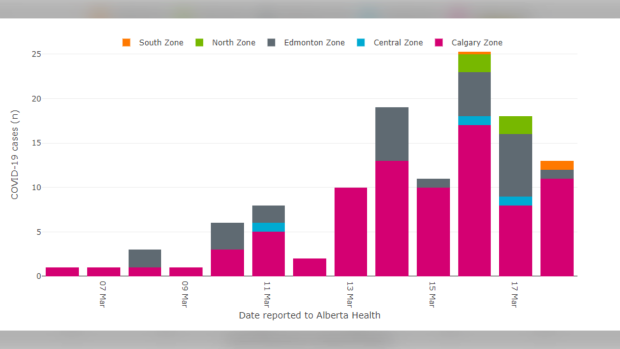
There are 119 COVID-19 cases in Alberta — the Edmonton health zone makes up for 23 per cent of them.
Out of the 14,477 coronavirus tests conducted in the province so far, 4,843 (33 per cent) were in the Edmonton zone.
Dr. Deena Hinshaw, the Alberta chief medical officer of health, previously said three of the province's community spread cases are in the Edmonton area.
For a deeper look at the statistics, click here.


