

Timeline of Monday's severe storms across central Alberta
'Very unstable' atmospheric conditions across central Alberta prompted a series of weather alerts Monday afternoon and into the evening.
According to the Prairie and Arctic Storm Prediction Centre, severe storms were forecasted to develop across the foothills to central regions of the province, with the potential for heavy rain, large hail, and wind gusts.
Tornado warnings are issued when thunderstorms capable of producing tornadoes and severe weather are happening or are likely to occur.
Watches are issued by Environment Canada when atmospheric conditions are favourable for the development of thunderstorms that could produce tornadoes.
Here is a timeline of the major alerts and warnings:
ALERT AT 7:28 P.M.
At 7:28 p.m., the previously issued tornado warnings and alerts for Kneehill County and Red Deer County were dropped after the storm was "no longer expected to produce a tornado."
The storm was still capable of producing damaging winds, locally intense rainfall, and large hail — with some communities seeing up to baseball sized hail.
As of 9:13 p.m., most of central Alberta remained under a tornado watch.
ALERT AT 7:05 P.M.
At that point, the rotating severe thunderstorm possibly producing a tornado was located 10 kilometres north of Highland Rand, moving southeast at 30 kilometres per hour. The communities of Highland Ranch and Huxley were in its path.
Officials warned residents and visitors in several counties of severe thunderstorms that had potential to produce tornadoes in central Alberta Monday afternoon.
"Seek shelter immediately in a basement or reinforced structure," the alert read. "Get low and put as many walls between yourself and the storm as possible.
"Stay away from windows, doors and outside walls. If you are on the highway and cannot avoid the tornado, seek shelter in a ditch or ravine."
"This is a dangerous and potentially life-threatening situation," the tornado warning read. "Take cover immediately, if threatening weather approaches.
"If you hear a roaring sound or see a funnel cloud, swirling debris near the ground, flying debris, or any threatening weather approaching, take shelter immediately.
ALERT AT 6:41 P.M.
The storm had Knee Hill Valley and Milnerton in its path, officials warned. It was moving southeast at 40 kilometres per hour.
Pine Lake was placed under a tornado warning at 6:33 p.m., alongside the Kneehill County communities of Torrington, Wimborne, Trochu, and Huxley. Elnora, Lousana, and Delbure were added around 7:15 p.m.
ALERT AT 6:12 P.M.
At that point, the storm was moving toward and then through the communities of Niobe and Penhold. Thirty minutes later the tornado warning for Penhold, Innisfail, and Bowden was ended.
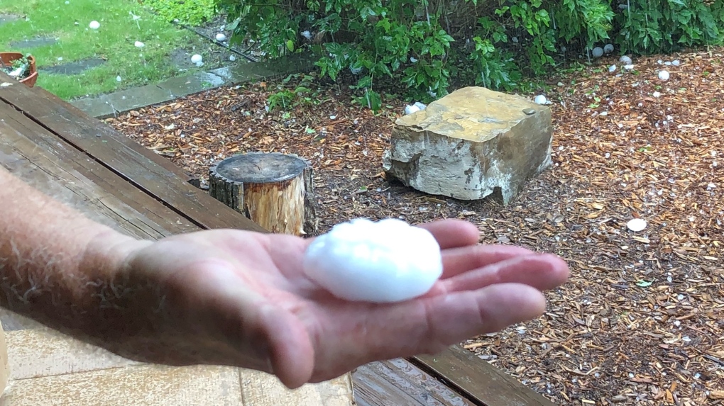 Egg sized hail fell near Penhold, Alta., around 6:20 p.m. on Monday, Aug. 1, 2022 (Supplied).
ALERT AT 6:04 P.M.
The tornado warning for Sylvan Lake and Stephansson House was dropped. Tornado watches for those and surrounding communities remained in effect. The storm had moved through Markerville and continued east.
ALERT AT 5:28 P.M.
Another severe storm was located 20 kilometres northwest of Markerville, moving east at 40 kilometres per hour. Officials indicated it could be producing a tornado.
At 5:50 p.m., a tornado warning was issued for Red Deer County, specifically near Penhold, Innisfail, and Bowden.
 Baseball size hail northwest of Markerville, Alta. (Source: Prairie Storm Chasers/Braydon Morisseau)
ALERT AT 4:33 P.M.
A storm capable of producing a tornado was warned about in Brazeau and Yellowhead counties, located at 4:26 p.m., 20 kilometres north of the Brazeau Dam. It was moving east at 40 kilometres per hour.
The alert was shortlived and ended 13 minutes later as tornadoes were "no longer expected" with that thunderstorm.
ALERT AT 3:48 P.M.
According to a tornado warning, a rotating thunderstorm possibly producing a tornado was near Rocky Mountain House, moving east at 50 kilometres per hour, with the storm edging closer to that community and Codner.
That alert was downgraded by 4:03 p.m. to a tornado watch.
ALERT AT 3:29 P.M.
The storm was moving east at 50 kilometres per hour, with the communities of Ferrier and Rocky Mountain House in its path, alerts said.
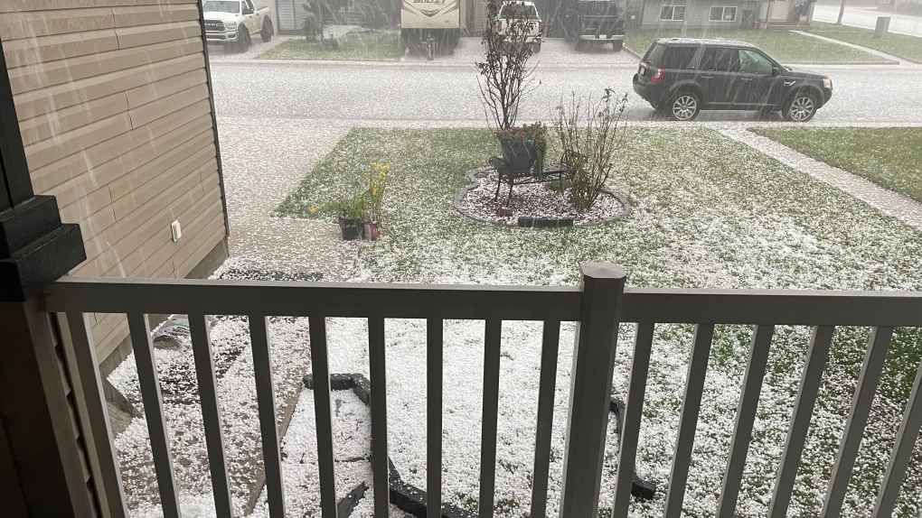 Massive amounts of hail fell in Rocky Mountain House as a severe storm moved through Alberta (Supplied).
ALERT AT 2:57 P.M.
An Alberta Emergency Alert was issued, indicating a rotating thunderstorm was possibly producing a tornado near Horburg, moving southeast at 35 kilometres per hour toward that community. That alert was dropped by 3:30 p.m.
ALERT AT 2:17 P.M.
As of 2:13 p.m., a storm was located around 10 kilometres west of Saunders, moving southeast at 40 kilometres per hour.
Several minutes later, the alert was updated to include that the communities of Saunders and Ancona were in the storm's path. That alert ended at 2:41 p.m. as the storm moved past the communities.
Shopping Trends
The Shopping Trends team is independent of the journalists at CTV News. We may earn a commission when you use our links to shop. Read about us.


CTVNews.ca Top Stories

5 rescued after avalanche triggered north of Whistler, B.C. RCMP say
Emergency crews and heli-skiing staff helped rescue five people who were caught up in a backcountry avalanche north of Whistler, B.C., on Monday morning.
Quebec fugitive killed in Mexican resort town, RCMP say
RCMP are confirming that a fugitive, Mathieu Belanger, wanted by Quebec provincial police has died in Mexico, in what local media are calling a murder.
Bill Clinton hospitalized with a fever but in good spirits, spokesperson says
Former President Bill Clinton was admitted Monday to Georgetown University Medical Center in Washington after developing a fever.
Trump again calls to buy Greenland after eyeing Canada and the Panama Canal
First it was Canada, then the Panama Canal. Now, Donald Trump again wants Greenland. The president-elect is renewing unsuccessful calls he made during his first term for the U.S. to buy Greenland from Denmark, adding to the list of allied countries with which he's picking fights even before taking office.
UN investigative team says Syria's new authorities 'very receptive' to probe of Assad war crimes
The U.N. organization assisting in investigating the most serious crimes in Syria said Monday the country’s new authorities were “very receptive” to its request for cooperation during a just-concluded visit to Damascus, and it is preparing to deploy.
Pioneering Métis human rights advocate Muriel Stanley Venne dies at 87
Muriel Stanley Venne, a trail-blazing Métis woman known for her Indigenous rights advocacy, has died at 87.
King Charles ends royal warrants for Ben & Jerry's owner Unilever and Cadbury chocolatiers
King Charles III has ended royal warrants for Cadbury and Unilever, which owns brands including Marmite and Ben & Jerry’s, in a blow to the household names.
Man faces murder charges in death of woman who was lit on fire in New York City subway
A man is facing murder charges in New York City for allegedly setting a woman on fire inside a subway train and then watching her die after she was engulfed in flames, police said Monday.
Canada regulator sues Rogers for alleged misleading claims about data offering
Canada's antitrust regulator said on Monday it was suing Rogers Communications Inc, for allegedly misleading consumers about offering unlimited data under some phone plans.
Calgary
-

Low Canadian dollar a 'double-edged sword' as more Americans travel north: economist
A Calgary economist says the low Canadian dollar is a mixed blessing, with data showing that more Americans are travelling north to make the most of their spending.
-
Taxpayers Federation unveils its annual spending 'Naughty and Nice List'
A media president and the Prime Minister have topped the Canadian Taxpayers Federation’s annual 'Taxpayer Naughty List' for 2024.
-
Roughriders acquire quarterback Maier's rights from Stampeders for '25 draft pick
The Saskatchewan Roughriders acquired the rights to veteran quarterback Jake Maier from the Calgary Stampeders on Monday for a 2025 eighth-round draft pick.
Lethbridge
-

'20 per cent increase': Interfaith Food Bank helps more than 900 households this holiday season
The last food bundles are heading out the door ahead of Christmas Day, as the Interfaith Food Bank nears the threshold of helping 1,000 households this holiday season.
-
Lethbridge Polytechnic announces new education and training opportunities for police
Lethbridge Polytechnic is taking steps to strengthen education and training opportunities for future police cadet graduates.
-
Milk River emergency department shuttered through Thursday
Alberta Health Services says the Milk River emergency department has temporarily closed due to a lack of physician coverage.
Saskatoon
-

Personalized license plates on the rise in Saskatchewan
You may have noticed a few more vanity plates on Saskatchewan roads in recent years, and every one of them comes with a personal story.
-
'There are lines': In year-end interview, NDP leader says Moe went too far in election campaign
Saskatchewan’s two main political leaders had agreed before October's provincial election not to target the families of candidates during the campaign, says Opposition NDP Leader Carla Beck.
-
Sask. RCMP on the scene of rollover on Highway 40
The Saskatchewan RCMP said Highway 40 was closed Monday afternoon following a rollover just west of Hafford, a village just under 100 kilometres northwest of Saskatoon.
Regina
-

'A nice way to connect': Christmas card exchange between Sask. friends spans 60 years
What started out as a little holiday fun between two Regina friends has turned into a tradition that now spans six decades.
-
Dog lost in Saskatchewan during cross-country trip reunited with family
A family moving from Ontario to Alberta in November had a scare when their family dog got loose during a stop in Dafoe, Sask. and ran away.
-
Estevan police officer arrested following SIRT investigation
An officer of the Estevan Police Service (EPS) is facing several charges following an investigation by the province’s police oversight agency.
Vancouver
-
5 rescued after avalanche triggered north of Whistler, B.C. RCMP say
Emergency crews and heli-skiing staff helped rescue five people who were caught up in a backcountry avalanche north of Whistler, B.C., on Monday morning.
-
B.C. woman sentenced for impaired driving crash that killed retired Mountie
A Vancouver Island woman who was high on drugs when she crashed a car into a pickup truck, killing a retired Mountie and injuring his two passengers, "did not realize what was happening and took no steps to avoid the accident" a B.C. Supreme Court judge found.
-
'They have their families to feed': YVR janitors set to escalate job action
Approximately 230 janitors at Vancouver International Airport are set to escalate job action Tuesday at "undisclosed areas of the airport."
Vancouver Island
-

B.C. woman sentenced for impaired driving crash that killed retired Mountie
A Vancouver Island woman who was high on drugs when she crashed a car into a pickup truck, killing a retired Mountie and injuring his two passengers, "did not realize what was happening and took no steps to avoid the accident" a B.C. Supreme Court judge found.
-
5 rescued after avalanche triggered north of Whistler, B.C. RCMP say
Emergency crews and heli-skiing staff helped rescue five people who were caught up in a backcountry avalanche north of Whistler, B.C., on Monday morning.
-
Cleanup underway after rockslide derails train in B.C.
No injuries were reported after a rockslide derailed a freight train, sending railcars into British Columbia's Fraser River, on Sunday night.
Toronto
-
 DEVELOPING
DEVELOPING Parts of Ontario under snowfall warning Monday as holiday travellers hit the road
Holiday travellers and commuters could be in for a messy drive on Monday morning as a significant round of snowfall moves into the region. Here are live updates on the situation in Toronto.
-
Everything you need to know about what’s open on Christmas in the GTA
Here's what you need to know about what's open and closed in the GTA over the Christmas holidays.
-
Pedestrian taken to hospital after being struck by vehicle in Forest Hill
A male pedestrian was rushed to the hospital after being struck by the driver of a vehicle in Toronto's Forest Hill area Monday night.
Montreal
-

Quebec fugitive killed in Mexican resort town, RCMP say
RCMP are confirming that a fugitive, Mathieu Belanger, wanted by Quebec provincial police has died in Mexico, in what local media are calling a murder.
-
Guzzo Group says it wants to protect its 500 employees
Although the Guzzo Group is currently in turmoil, it is reassuring its employees and customers about the year ahead.
-
Snow on the way as Montreal is under weather advisory
A weather advisory has been issued for the Greater Montreal area, with 10 to 15 cm of snow expected to hit the ground.
Atlantic
-

Court of appeal certifies class action lawsuit against health authority, former nurse
A New Brunswick mother who is the lead plaintiff in a court case has received an early Christmas gift after the province’s top court certified her class-action lawsuit.
-
No need to dream, White Christmas all but assured in the Maritimes
An early nor'easter followed by a low-pressure system moving into the region all but ensure a Maritime White Christmas
-
CTV’s Katie Kelly solves decades old mystery involving “anchor” tattoo
It’s been almost two decades since a 21-year-old man from New Glasgow, N.S., got a tattoo of CTV’s Bruce Frisko, but it’s a piece of Maritime history that hasn’t been forgotten.
Winnipeg
-

An alleged sniper, pair of animal claims featured on MPI’s top five fraud list for 2024
From hitting animals that weren’t there to a sniper that didn’t exist, Manitoba Public Insurance has released its top five frauds of 2024.
-
Manitoba government to make permanent cut to gas tax
Manitobans can expect to see a permanent change at the gas pump as early as next week
-
Winnipeg police arrest corrections officer following sexual assault of a youth
A corrections officer at a “youth custody facility” has been arrested following a number of sexual assaults against a youth.
Ottawa
-

Traffic dispute threatens to dampen holiday spirit on Taffy Lane
A visit to Ottawa's Taffy Lane in Orléans is a staple this time of year, but a dispute amongst neighbours over traffic congestion is threatening to dim the magic of the holidays for one neighbour.
-
Ottawa mayor speaks on transit funding, federal turmoil in year-end interview
Ottawa Mayor Mark Sutcliffe spoke with CTV News on a variety of issues, including transit, the city budget and political turmoil on Parliament Hill in a year-end interview.
-
SNOWFALL WARNING
SNOWFALL WARNING Pre-Christmas storm forecasted in Ottawa with up to 20 cm of snow tonight
Environment Canada has issued a snowfall warning for Ottawa and parts of eastern Ontario with a snowstorm in the forecast Monday afternoon and into the evening.
Northern Ontario
-

Fatal snowmobile crash in northern Ont. near Parry Sound
A 30-year-old has died following a snowmobile crash near Parry Sound on Sunday.
-
Teen passed out at coffee shop with bottle of booze on the table, northern Ont. police say
A 19-year-old from Blind River is facing several charges following incidents at a coffee shop and in jail.
-
Man charged with damaging downtown Sudbury eatery
A man free on probation has been charged with causing significant damage to a restaurant on Elgin Street in downtown Sudbury over the weekend.
Barrie
-

Several collisions reported along Highway 11 as driving conditions deteriorate
Highway 11 was closed briefly in Oro-Medonte on Monday afternoon as driving conditions deteriorated, causing multiple collisions.
-
Theft, vehicle break-ins, and fraud top police reports during holidays
Police in Barrie are urging residents to be vigilant this holiday season, as theft, theft from vehicles, and fraud consistently rank as the most reported crimes during this time of year.
-
Student charged, firearms seized after threats against school: police
Police say officers found several firearms during a search at a teen’s home after he allegedly made violent threats against a secondary school.
Kitchener
-

Winter weather travel advisory before Christmas
Anyone planning to travel is being urged to be prepared as 5 to 15 cm of snow could hit a large portion of southern Ontario on Monday.
-
Beloved bookstore in Uptown Waterloo forced to close for months following fire
A beloved bookstore in Uptown Waterloo is bearing the brunt of some holiday misfortune.
-
Must-see moments of 2024: A superstar surprise, roundabout resident and CKCO studios come down
From a WWE surprise for a Guelph superfan, to the recovery of a lost aviation artifact, to a reporter getting the story right from the goose's mouth, here are some of our can’t-miss moments from 2024.
London
-

Blast of Ontario snow brings weather warnings, signs of white Christmas
A white Christmas is forecasted for parts of Ontario as winter weather and snowfall sweeps across the province Monday.
-
91-year-old harness driver victorious at The Raceway in London, Ont.
A 91-year-old harness driver raced his way to victory on Friday night with his horse, Willy Strike.
-
SIU concludes LPS was justified in striking a man in August arrest
Following an incident in August, the province’s police watchdog has concluded that a London Police Service officer did not commit a criminal offense.
Windsor
-

Restaurant staff aid in rescue of two men that fell into the frigid waters of the Detroit River
Windsor police say that shortly before 9:00 p.m. on Dec. 20, officers were called after a man fell into the water while standing too close to the marina wall. A second man jumped in to help him.
-
Early morning blaze that displaced two people deemed suspicious
Windsor fire was on scene of an early morning blaze in the 1500 block of Pelissier Street on Monday.
-
Child luring investigation sees Windsor resident charged
According to Essex OPP, 45-year-old Shaun Ouellette is facing charges of luring a person under 16 years of age by means of telecommunication.


