Thunderstorms pass through Edmonton, Red Deer and west-central Alberta
 Lightning seen in Beaver County north of Tofield, Alta., on June 11, 2024. (Submitted: Brenda Carlson)
It was a beautiful spring day in Edmonton, but it's ending on a stormy note.
Severe thunderstorms that developed over the city late Tuesday afternoon and brought wind, rain and lightning have moved off to the east-northeast, with the threat of severe storms ending for the time being.
As of 7 p.m. Tuesday, Environment and Climate Change Canada (ECCC) had ended the severe thunderstorm warning for Edmonton and area and kept the city, St. Albert and Sherwood Park under a thunderstorm watch alert.
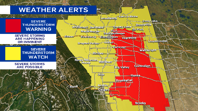
ECCC had issued a severe thunderstorm warning at 5:15 p.m. for Edmonton and area as well as regions of the city south along Highway 2 through Red Deer and Calgary.
Earlier severe thunderstorm warnings for areas near Red Deer, Olds, Grande Cache, Botten, Amundson and Alder Flats have also ended.
The Edmonton region will continue to see rain and a few non-severe thundershowers early in the evening. The potential exists for a few more thunderstorms to redevelop mid-evening.
Cloudy, wet, windy and cool conditions will take over on Wednesday with gusts in the 40-50 km/h range through most of the day in Edmonton.
Rain may be in the area for much of the day, but the morning will likely be wetter than the afternoon.
A severe thunderstorm 'warning' means the severe storms are occurring or imminent, while a 'watch' means potential for severe weather.
 A severe thunderstorm warning on June 11, 2024, in Edmonton and area ended early in the evening as storms moved east-northeast of the city. (Josh Classen/CTV News Edmonton)
High over 20 C, clouds develop in afternoon, thunderstorms
For the second consecutive day, we got into the low 20s in Edmonton.
Sunshine and light wind early in the day gave way to increasing afternoon cloud then thunderstorms.
Edmonton's had back-to-back 20-degree days just a few times this spring:
- May 9/10
- May 27/28
- June 1/2
And there are no three or four-days stretches in the 20s.
That trend will continue as cooler air settles in for Wednesday.
The heaviest, steadiest rain will be in east-central/northeast Alberta.
Here's the forecast for Edmonton and area:
Wednesday - Cloudy with periods of light rain.
Wind: WNW 30 gusting to 50 km/h
Morning Low: 11
Afternoon High: 14
Thursday - Cloudy in the morning, clearing in the afternoon.
Morning Low: 9
Afternoon High: 19
Friday - Partly cloudy. 30% chance of an evening shower/thunderstorm.
Morning Low: 11
Afternoon High: 22
Saturday - Mix of sun & cloud. 30% chance of a late-day shower.
Morning Low: 11
Afternoon High: 19
Sunday - Mostly cloudy. 40% chance of showers.
Morning Low: 9
Afternoon High: 16
CTVNews.ca Top Stories

W5 Investigates A 'ticking time bomb': Inside Syria's toughest prison holding accused high-ranking ISIS members
In the last of a three-part investigation, W5's Avery Haines was given rare access to a Syrian prison, where thousands of accused high-ranking ISIS members are being held.
Trudeau Liberals' two-month GST holiday bill passes the House, off to the Senate
The federal government's five-page piece of legislation to enact Prime Minister Justin Trudeau's promised two-month tax break on a range of consumer goods over the holidays passed in the House of Commons late Thursday.
Irregular sleep patterns may raise risk of heart attack and stroke, study suggests
Sleeping and waking up at different times is associated with an increased risk of heart attack and stroke, even for people who get the recommended amount of sleep, according to new research.
California man who went missing for 25 years found after sister sees his picture in the news
It’s a Thanksgiving miracle for one California family after a man who went missing in 1999 was found 25 years later when his sister saw a photo of him in an online article, authorities said.
As Australia bans social media for children, Quebec is paying close attention
As Australia moves to ban social media for children under 16, Quebec is debating whether to follow suit.
Notre Dame Cathedral: Sneak peak ahead of the reopening
After more than five years of frenetic reconstruction work, Notre Dame Cathedral showed its new self to the world Friday, with rebuilt soaring ceilings and creamy good-as-new stonework erasing somber memories of its devastating fire in 2019.
Canada Post temporarily laying off striking workers, union says
The union representing Canada Post workers says the Crown corporation has been laying off striking employees as the labour action by more than 55,000 workers approaches the two-week mark.
Can't resist Black Friday weekend deals? How to shop while staying within your budget
A budgeting expert says there are a number of ways shoppers can avoid getting enveloped by the sales frenzy and resist spending beyond their means.
Montreal shopping mall playing 'Baby Shark' song to prevent unhoused from loitering
A shopping mall and office complex in downtown Montreal is being criticized for using the popular children's song 'Baby Shark' to discourage unhoused people from loitering in its emergency exit stairwells.


