Josh Classen's forecast: Warm, with occasional hit-n-miss showers

Sunday's high of 27 C was the warmest day of 2022 (so far) in Edmonton.
Here are the three "hottest" days:
June 26: 26.9
June 3: 25.3
June 21: 24.8
Yep...we've only been above 25 C TWICE this year. So, we haven't had much any really HOT weather.
We HAVE, however, put up some respectable temperatures compared to the historical averages.
Our average daily high for June is 21 C.
In June 2022, it's 21.2 C (and should increase slightly before month's end).
Sunday was also the city's 20th day above 20 C. That's ahead of the long-term "normal" of 18 days and we'll probably get to at least 22.
Tuesday and Thursday "should" break 20 C. It's today and Wednesday that "might".
We'll be partly cloudy through today with a chance of some scattered showers (and/or thunderstorms) pushing through the Edmonton region from the NW this afternoon.
It certainly won't rain ALL DAY. But, some precip before the day is done is certainly possible.
NW Alberta is getting that precip this morning and we'll have to keep an eye on the Red Deer region for some storms late today.
Tuesday features a late-evening shower or thunderstorm risk.
We'll get into the low to mid 20s in the afternoon with a "mix of sun & cloud" and then the evening could bring some precip.
A low pressure system sweeps through southern Alberta Tuesday night and off into southern SK by Wednesday morning.
We'll also have a cold front pressing in from the north of a LOW in northern MB.
Once the late-night precip pushes through from south to north...the flow will swing around and come at us FROM north on Wednesday.
So, we'll see some showers or periods of rain push back through north-central AB and the Edmonton area on Wednesday.
AND...after getting into the mid 20s Tuesday, we'll be hard-pressed to get to 20 on Wednesday.
The LONG-TERM outlook for the end of the Canada Day long weekend is trending hotter, though.
I have daytime highs in the mid to upper 20s for Fri/Sat/Sun and much of next week look to be in the mid 20s (maybe hotter) as well.
Here's the forecast for Edmonton and area:
Today - Partly cloudy. 40% chance of a shower and/or thunderstorm this afternoon.
High: 20
Tonight - Mostly cloudy overnight.
9pm: 17
Tuesday - Mix of sun & cloud. 60% chance of a shower or thunderstorm late in the evening.
Morning Low: 12
Afternoon High: 24
Wednesday - Mostly cloudy. 70% chance of showers or rain.
Morning Low: 12
Afternoon High: 18
Thursday - Mix of sun & cloud.
Morning Low: 12
Afternoon High: 22
Friday - Partly cloudy. 40% chance of a late-day shower or thunderstorm.
Morning Low: 10
Afternoon High: 25
Saturday - Partly cloudy.
Morning Low: 13
Afternoon High: 27


CTVNews.ca Top Stories

Grandparents killed in wrong-way crash on Hwy. 401 identified
A 60-year-old man and a 55-year-old woman killed in a wrong-way crash on Highway 401 earlier this week have been identified by the Consulate General of India in Toronto.
Police arrest 3 Indian nationals in killing of B.C. Sikh activist Hardeep Singh Nijjar
Three people have been arrested and charged in the killing of B.C. Sikh activist Hardeep Singh Nijjar – as authorities continue investigating potential connections to the Indian government.
Suter scores late goal, clinches series for Canucks
Pius Suter scored with 1:39 left and the Vancouver Canucks advanced to the second round of the NHL playoffs with a 1-0 victory over the Nashville Predators on Friday night in Game 6.
TD worst-case scenario more likely after drug money laundering allegations: analyst
TD Bank Group could be hit with more severe penalties than previously expected, says a banking analyst after a report that the investigation it faces in the U.S. is tied to laundering illicit fentanyl profits.
Quebec man who threatened Trudeau, Legault online sentenced to 20 months in jail
A Quebec man who pleaded guilty to threatening Prime Minister Justin Trudeau and Premier François Legault has been sentenced to 20 months in jail.
Human remains found in rural Sask. possibly a decade old, RCMP say
RCMP say human remains found in a rural area in central Saskatchewan may have been there for a decade or more.
Britney Spears 'home and safe' after paramedics responded to an incident at the Chateau Marmont, source tells CNN
A source close to singer Britney Spears tells CNN that the pop star is 'home and safe' after she had a 'major fight' with her boyfriend on Wednesday night at the Chateau Marmont in West Hollywood.
Canadian doctor concerned new weight-loss drug Wegovy may be used inappropriately
As Wegovy becomes available to Canadians starting Monday, a medical expert is cautioning patients wanting to use the drug to lose weight that no medication is a ''magic bullet,' and the new medication is meant particularly for people who meet certain criteria related to obesity and weight.
Drew Carey is never quitting 'The Price Is Right'
Drew Carey took over as host of 'The Price Is Right' and hopes he’s there for life. 'I'm not going anywhere,' he told 'Entertainment Tonight' of the job he took over from longtime host Bob Barker in 2007.
Shopping Trends
The Shopping Trends team is independent of the journalists at CTV News. We may earn a commission when you use our links to shop. Read about us.


Calgary
-
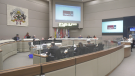
Calgary council wraps second week of public hearing on blanket rezoning
As of Friday morning, 611 Calgarians had voiced their opinions about the city's proposed blanket rezoning, with 92 still remaining.
-
Globe Cinema sale could signal a cultural shift in Calgary’s developing film industry
Many in Calgary’s film industry are worried about the potential sale of another iconic downtown theatre, and what it could mean for the local arts scene.
-
Alberta impaired driving victims applaud Mandatory Alcohol Screening in Ontario
Mandatory Alcohol Screening has been in place in Alberta for the past few years and a move by the Ontario Provincial Police to begin enforcing breath samples at all traffic stops is being applauded by local victims of impaired driving.
Lethbridge
-

Southern Alberta animal shelters overrun with abandoned pets
Animal shelters across the province are finding themselves frequently at capacity -- or more.
-
Woman charged in connection with fatal crash
Lethbridge police say impaired driving is to blame in a fatal crash that killed a 25-year-old man on Thursday.
-
Contractors want to repurpose Milk River high school rather than see it demolished
The bell at Erle Rivers High School in Milk River, Alta., will ring for the last time on June 26, as the 114-year-old school is scheduled to be torn down to make way for a new K-12 school.
Saskatoon
-

Deflated for now, Saskatoon's Golf Dome is about to get a makeover
A lesser known fixture of Saskatoon's skyline is coming down for repairs and renovations.
-
Saskatoon police investigating city’s 9th homicide
The Major Crime Section of the Saskatoon Police Service has taken over the investigation into the death of a 30-year-old man, marking the city’s 9th homicide in 2024.
-
Company fined $260,000 for workplace injury in Saskatoon
Richelieu Hardware Canada Ltd. was fined a hefty $260,000 for a workplace safety violation leading to a serious worker injury.
Regina
-

Human remains found in rural Sask. possibly a decade old, RCMP say
RCMP say human remains found in a rural area in central Saskatchewan may have been there for a decade or more.
-
Sask. Party raises $3.6M, leads in donations ahead of looming election call
Premier Scott Moe's Saskatchewan Party has received millions of more dollars in donations compared with rivals ahead of this year's election.
-
Regina's North Central Family Centre launches Hopes and Dreams campaign
The North Central Family Centre (NCFC) has launched a capital campaign to help aid in the completion of a major project they are in the midst of building.
Vancouver
-

Suter scores late goal, clinches series for Canucks
Pius Suter scored with 1:39 left and the Vancouver Canucks advanced to the second round of the NHL playoffs with a 1-0 victory over the Nashville Predators on Friday night in Game 6.
-
Former B.C. Mountie fined for hiring foreign nanny without work permit
A former Mountie who pleaded guilty to illegally employing a foreign national without a work permit has been ordered to pay a $2,000 fine and have no contact with her former nanny for two years.
-
Police arrest 3 Indian nationals in killing of B.C. Sikh activist Hardeep Singh Nijjar
Three people have been arrested and charged in the killing of B.C. Sikh activist Hardeep Singh Nijjar – as authorities continue investigating potential connections to the Indian government.
Vancouver Island
-
Suter scores late goal, clinches series for Canucks
Pius Suter scored with 1:39 left and the Vancouver Canucks advanced to the second round of the NHL playoffs with a 1-0 victory over the Nashville Predators on Friday night in Game 6.
-
Police arrest 3 Indian nationals in killing of B.C. Sikh activist Hardeep Singh Nijjar
Three people have been arrested and charged in the killing of B.C. Sikh activist Hardeep Singh Nijjar – as authorities continue investigating potential connections to the Indian government.
-
B.C. man's sand sculpture park a lesson in creativity, catastrophe and resilience
When Damon Langlois visited the beach as a boy, he never would have imagined how significant sand would become in his life.
Toronto
-
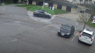
Police officer hit by driver of fleeing vehicle in Toronto
York Regional Police say they are continuing to search for a suspect in an auto theft investigation who was captured on video running over a police officer in Toronto last month.
-
Grandparents killed in wrong-way crash on Hwy. 401 identified
A 60-year-old man and a 55-year-old woman killed in a wrong-way crash on Highway 401 earlier this week have been identified by the Consulate General of India in Toronto.
-
Video shows suspect setting Toronto-area barbershop on fire
Video of a suspect lighting a Richmond Hill barbershop on fire earlier this week has been released by police.
Montreal
-

Premier Legault reiterates that McGill pro-Palestinian camp must be dismantled
Quebec Premier François Legault reiterated that the pro-Palestinian encampment at McGill University must be dismantled while police remain 'on the lookout for new developments.'
-
Judge worries amendment to Quebec language law will cause 'undue delays' for English trials
A Quebec judge overseeing the trial of a person accused of killing a cyclist with their car has raised concerns that an amendment to the province's language charter could cause 'undue delays' for trials held in English.
-
'Congratulations': Celine Dion praises Montreal DJ for new mashup featuring her vocals
Quebec singing legend Celine Dion has praised a Montreal DJ for creating a mashup featuring one of her songs with U.K. producer Majestic.
Atlantic
-
Police launch Mandatory Alcohol Screening program in Halifax area
An initiative called the Mandatory Alcohol Screening (MAS) program is designed to cut down on the number of drunk drivers on the road in the Halifax area.
-
'I have the will to live': N.B. woman needs double lung transplant
A New Brunswick woman suffering from sarcoidosis, a disease that limits your lung capacity, is in need of a double lung transplant.
-
Officers seize 28kg of elvers at N.S. holding facility
Fishery officers seized nearly 30 kilograms of elvers at a Yarmouth County, N.S., holding facility on Wednesday, arresting three people in the process.
Winnipeg
-
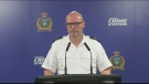
2 charged after police find 'concerning and diverse' explosives at Manitoba home
Winnipeg police say they have arrested two people in their 20s after a large amount of explosives were found in a home outside of Winnipeg, Man.
-
Manitoba man sentenced to house arrest for keeping fishing tournament funds meant for Children's Hospital Foundation
A Manitoba man who pleaded guilty to keeping the funds raised from an ice-fishing fundraiser for the Children's Hospital Foundation of Manitoba has been handed a sentence of 18 months house arrest.
-
'I never thought it would be anything this size': City committee approves oversized garage without permit
A city committee has given the green light to an oversized garage, where no permit was pulled.
Ottawa
-

'He was the coolest kid': Remembering Griffin Bell ahead of CN Cycle for CHEO
Photographers will tell you that one of the best times to capture incredible images is just after sunrise or right before sunset. That time is known as the golden hour. It's the light that starts each day, offering hope and wonder about the day ahead. Griffin Bell exemplified that hope and light in a way that few others ever will.
-
Nighttime LRT construction derails east-end residents' sleep
Residents of an Orléans neighbourhood are voicing their frustration as overnight work on Stage 2 LRT causes disturbances for those living next to the construction site.
-
Two Ontario nurses help deliver baby during a flight to Dubai
Two registered nurses from Ottawa and Kingston have been an integral part in the delivery of a baby on board a flight heading to Dubai.
Northern Ontario
-

Northern Ont. man guilty of three counts of first-degree murder in Sudbury firebombing
The jury deciding the fate of a man responsible for a fatal firebombing in Sudbury found him guilty of three counts of first-degree murder Friday afternoon.
-
Almost $17K in fines for illegal hunting, fishing in northern Ont.
Three men from southern Ontario and a man from Texas have been fined a total of $16,700 for illegal hunting and fishing in September 2021.
-
New Hamburg, Ont. family can't get truck's faulty transmission fixed due to aftermarket attachment
A New Hamburg family is feeling deflated after buying a new Toyota hybrid truck.
Barrie
-
80-year-old Ont. man to face jury in historical sexual assault case involving children
A trial date has been set for an Ontario senior facing allegations of historical sexual offences involving children.
-
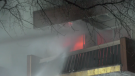
Bracebridge plant pauses operations after destructive fire
On Thursday night, 30 firefighters battled a destructive fire that broke out in a facility in Bracebridge Ont.
-
Driver charged with speeding while impaired on Hwy 11
A driver was handed a three-month licence suspension for allegedly speeding while impaired on Highway 11 in Muskoka.
Kitchener
-

WRDSB to lay off 106 elementary school teachers
More than 100 teachers at the Waterloo Region District School Board (WRDSB) are learning they have been declared surplus will likely be out of a job as of Aug. 12.
-
Search underway for missing 17-year-old in Kitchener
There was a large police presence in a Kitchener neighbourhood Friday evening as officers searched for a missing 17-year-old.
-
Chemical spill could be cause of stinky water in Puslinch, Ont., new report says
People living in Puslinch, Ont. may have the answer to why their water smelled so bad last year.
London
-

'I felt like the wildebeest in National Geographic': Cyclist recounts wild dog attack
Neighbours east of Dorchester are demanding action after an alleged attack by dogs.
-
Benzene levels 424 times acceptable levels: Aamjiwnaang First Nation
The Aamjiwnaang First Nation near Sarnia says it has recorded benzene levels 424 times above acceptable levels coming from a nearby chemical plant.
-
Trio found guilty of sex trafficking charges
Three people were found guilty on Friday afternoon of sex-trafficking related charges involving teenaged females.
Windsor
-

Grade 6 student saves choking classmate
A lesson learned at school saved a life Thursday.
-
Two people exchange gunfire in Leamington parking lot
Essex County OPP investigators are asking for help in identifying an individual involved in a shooting incident in a Leamington parking lot.
-
Suspect arrested after allegedly pointing an airsoft gun at pedestrians
The Windsor Police Service (WPS) has arrested a suspect for allegedly pointing an airsoft pistol at pedestrians and passing vehicles in downtown Windsor.


