Hourly updates of Thursday's storm across Alberta
With a risk of severe thunderstorms and potential for tornado development, CTV News Edmonton's meteorologists Josh Classen and Cory Edel will keep you updated throughout the day here.
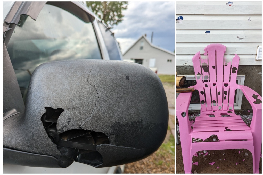
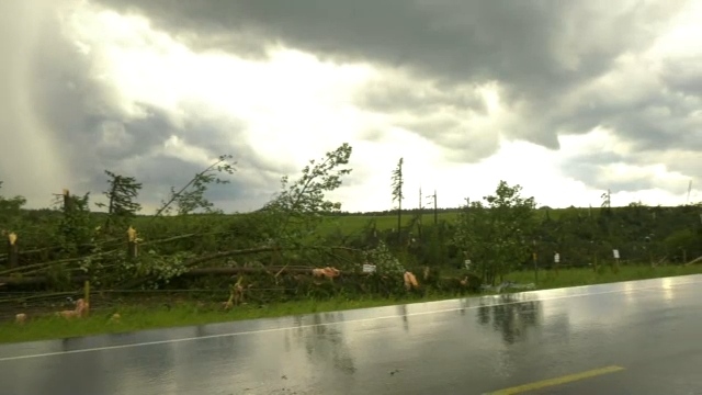
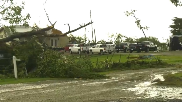
- Damage from the storm south of Sundre, Alta.
- Funnel cloud images from the Sundre area
- Ping pong to golf ball size hail damage in Oyen, Alta.
Josh Classen at 9:40 p.m.:
The storm system has now moved off to the NE of Edmonton and will continue to track away from the city. The severe thunderstorm warning has ended for the city and surrounding areas. No further storminess is expected in the city tonight.
Storms (severe in some spots) will continue in east-central Alberta tonight. We also have some storms in the Whitecourt region that will track move northeast this evening and overnight.
This will be the final update to this article. Thank you for following along.
Josh Classen at 9:15 p.m.:
The worst of the storm is moving out of the NE end of Edmonton. Fort Saskatchewan and area are next in line for the torrential downpours.
If you live in south Edmonton, you were mostly missed by the storm, with only a few spots getting some rain. The severe thunderstorm warning for the city of Edmonton will likely be ended soon.
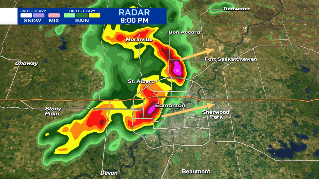
Josh Classen at 9:00 p.m.:
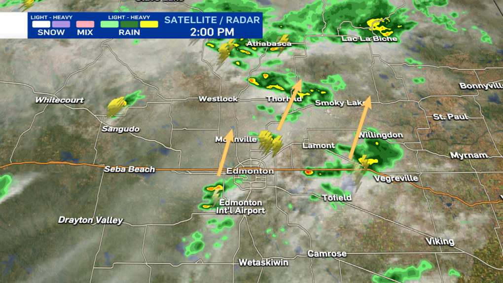
As the storm rips across Edmonton, most areas are just getting torrential downpours and some wind. A few areas are reporting small pea-sized hail. AND...it probably won't get more severe than that. Again, it's still looking like most areas should get about 30 min of nasty weather before conditions improve.
Josh Classen at 8:45 p.m.:
Storm will push across the city of Edmonton with heavy rain, strong wind gusts and possibly some pockets of hail. Most areas will only get intense rainfall. The storm should last for approximately 30 min for any given area, although it may not rain AS HEAVILY for that entire duration.
Josh Classen at 8:30 p.m.:
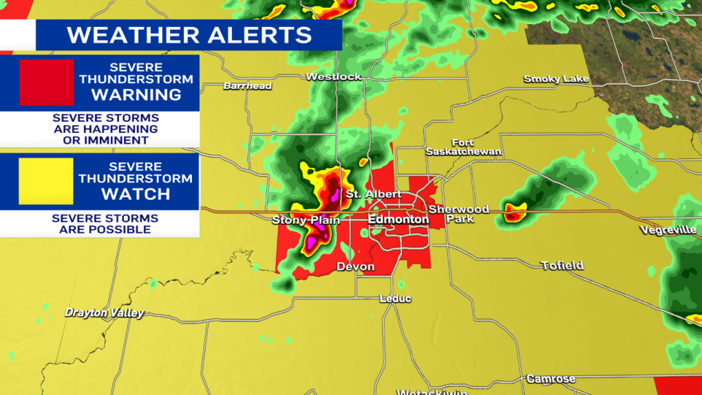
The city of Edmonton and surrounding areas are now under a Severe Thunderstorm WARNING. The storms are moving ENE at approx 30 km/h. Torrential downpours are the primary threat, along with strong wind gusts. Pockets of hail are possible as well.
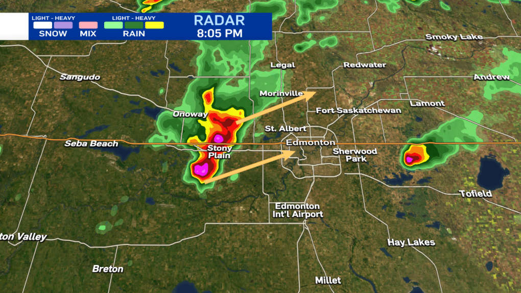
Josh Classen at 8:05 p.m.:
Severe storms in the Stony Plain/Spruce Grove region are moving ENE at about 30 km/h.
These storms are capable of producing toonie to ping pong ball-sized hail, downpours and strong wind gusts. It is likely that at least western and northwestern parts of Edmonton will get hit by these storms over the course of the next hour or two.
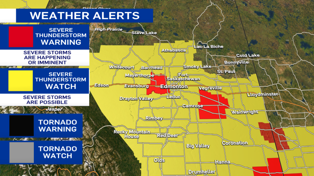
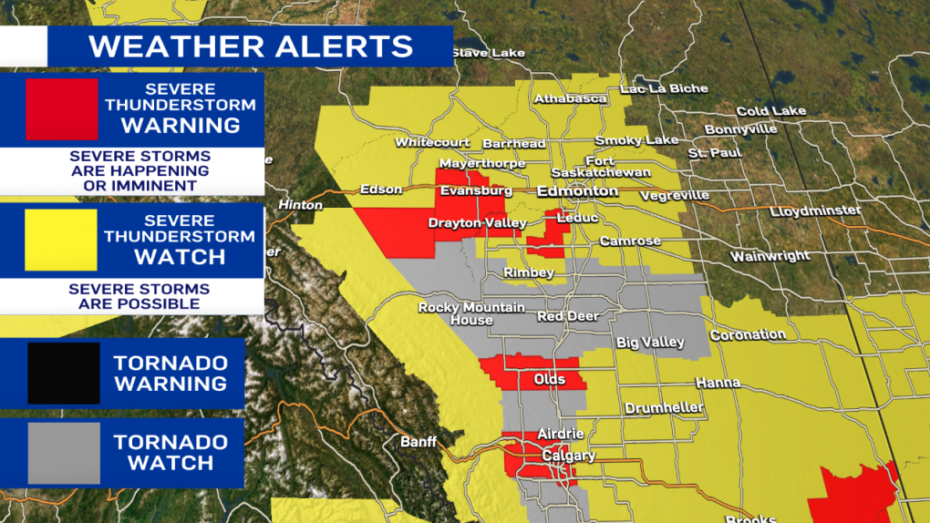
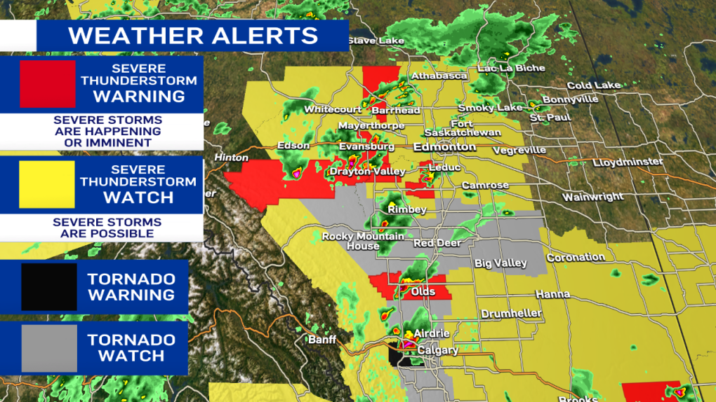
Also - here's the latest on the severe weather alerts. All of the tornado watches have been ended. Severe thunderstorm warnings and watches remain in effect.
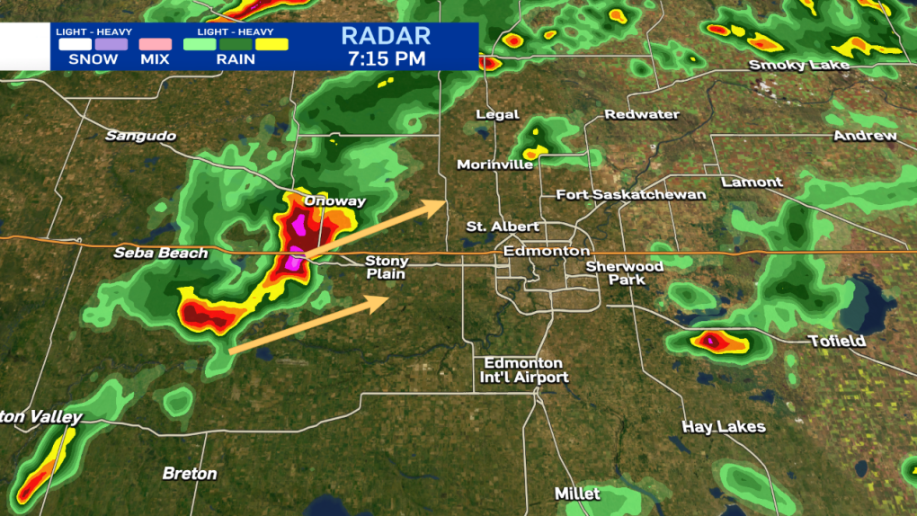
Josh Classen at 7:15 p.m.:
A severe storm just west of Stony Plain is slowly tracking northeast. Toonie to ping pong ball-sized hail, heavy rain and strong wind gusts are the main threats. That storm is part of a broken line of showers and storms heading NE. The nastiest storm (pink cell in the radar image) will likely miss the city (or at least the vast majority of it. But, Stony Plain and areas just north and NW of Edmonton could be in for quite the storm over the next few hours.
The concern for the city of Edmonton is the southern edge of that line. As it gradually inches further east, there is still the potential it could move into the city later this evening.
So...as I said at 6:30 - there's no imminent threat of a storm over the city. But, we're still not completely "out of the woods."
I'll continue to monitor the situation and send another update in an hour or so.
Josh Classen at 6:30 p.m.:
Thunderstorms continue to hit some areas SE of Edmonton and to the west near Lake Wabamun. However, aside from a few scattered showers, the city has been missed and MIGHT get missed altogether.
A severe thunderstorm WATCH remains in effect. However, the risk looks much lower than just an hour or two ago. IF we're going to get anything, it'll be later this evening as the line of storms from Drayton Valley to Onoway moves ENE. It appears that may slip past the city, though. We'll continue to monitor the situation. But, there is no imminent threat of severe weather at this point.

Josh Classen at 5:40 p.m.:
A severe thunderstorm WATCH remains in effect for the city of Edmonton. Right now, the storms "of concern" are just SE of the city and seem to be spinning back towards the NNW, potentially getting closer to Edmonton over the next hour. Those two storms near Hay Lakes are not severe as of now but may be producing some small hail and are definitely dropping heavy rain.
The severe storms near Seba Beach will slowly move NE, and most of that should pass north of Edmonton.
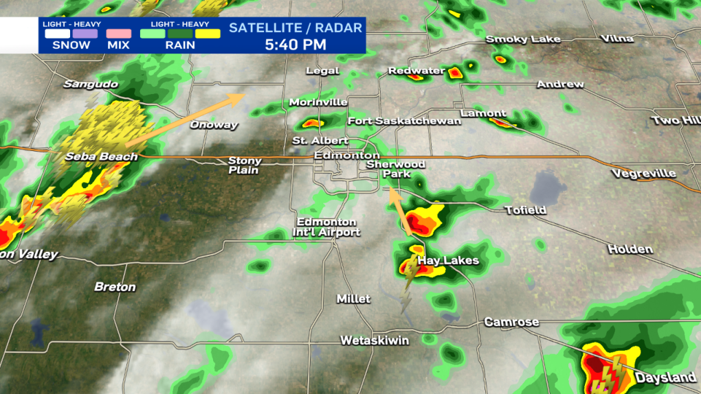
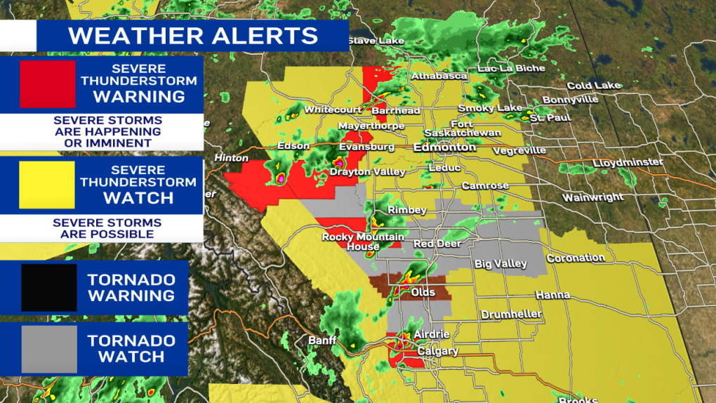
Here are the latest advisories, including Tornado WATCHes for the areas in grey (including Red Deer and Calgary).

Josh Classen at 4:55 p.m.:
The tornado warning for areas just west of Calgary has ENDED and has been replaced by a severe thunderstorm WARNING.
Isolated storms continue to close in on the Edmonton region and surrounding areas with the threat of severe storms continuing through this evening.
RCMP confirm to CTV News that the storm damaged approximately six to nine homes. Officers from Olds, Sundre, and Didsbury deployed to check on area residents, with everyone accounted for.

Josh Classen at 4:35 p.m.:
A tornado WARNING has been issued for a storm just northwest of Calgary. The storm may be producing a tornado and is 15 km south of Cochrane, heading east at 20 km/h.
The storm that I mentioned earlier (west of Millet) has now been upgraded to a severe thunderstorm WARNING as it is likely producing up to toonie-sized hail and heavy downpours. That storm is moving north at 20 km/h towards Devon and the Edmonton region.
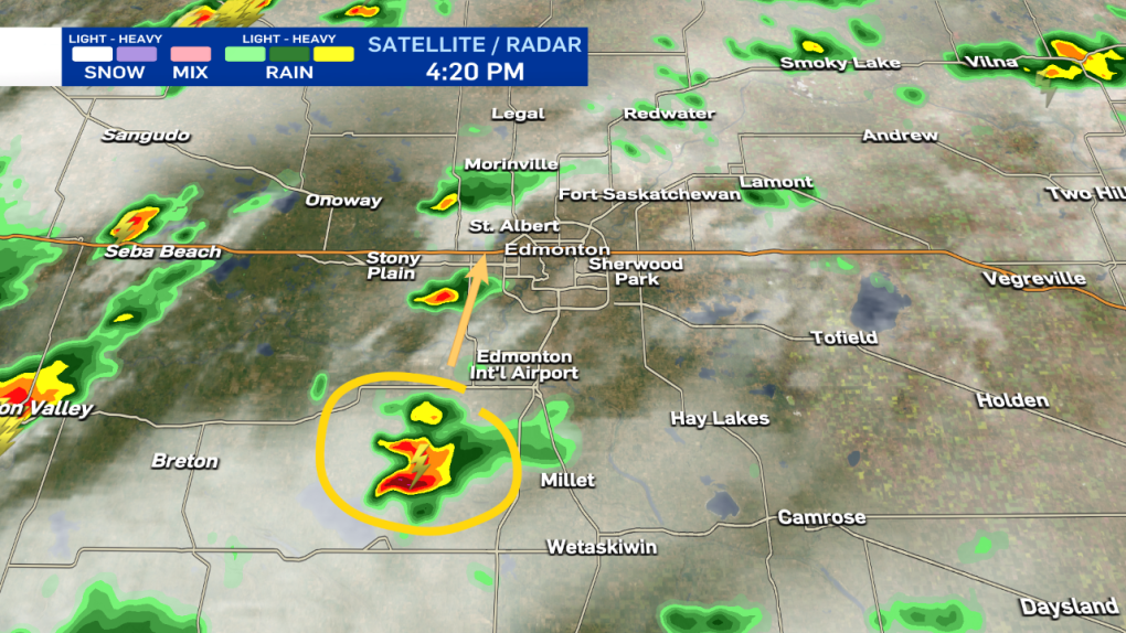
Josh Classen at 4:20 p.m.:
It's still a non-severe storm. But, we're keeping an eye on this cell west of Millet heading north towards the west end of the Edmonton region. We'll have more on all of this activity on CTV News Edmonton tonight at 5, 6 & late night at 11:30 p.m.
Josh Classen at 3:55 p.m.:
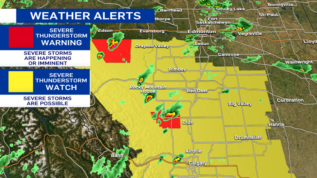
A severe thunderstorm WARNING has been issued for a storm west of Drayton Valley heading towards Drayton Valley. It is likely producing hail, as well as heavy downpours. Radar indicates this storm may also be possible of producing a tornado.
Another storm further west is has also turned severe with large hail likely.
The tornado warning has ENDED for the storm south of Sundre although that area just west of Olds continues to get pummeled with heavy rain and likely hail. The area is now under a severe thunderstorm WARNING.
Josh Classen at 3:30 p.m.:
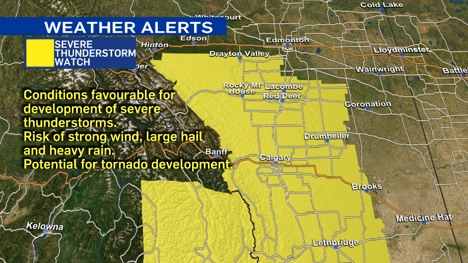
A Severe thunderstorm WATCH is now in effect for the City of Edmonton and regions to the north towards Athabasca and east towards Vegreville. This alert area will likely continue to be expanded further east this evening.
A WATCH means there is the potential for storms to turn severe. However, it remains important to note that most areas within that "watch zone" will not get severe weather. At this point, we don't have exact timing or location details for storms within the WATCH.
Severe Thunderstorm WARNINGs remains in effect for storms south of Edson, near Rocky Mountain House and just NW of Barrhead. All of those storms are moving NE and producing heavy downpours as well as hail.
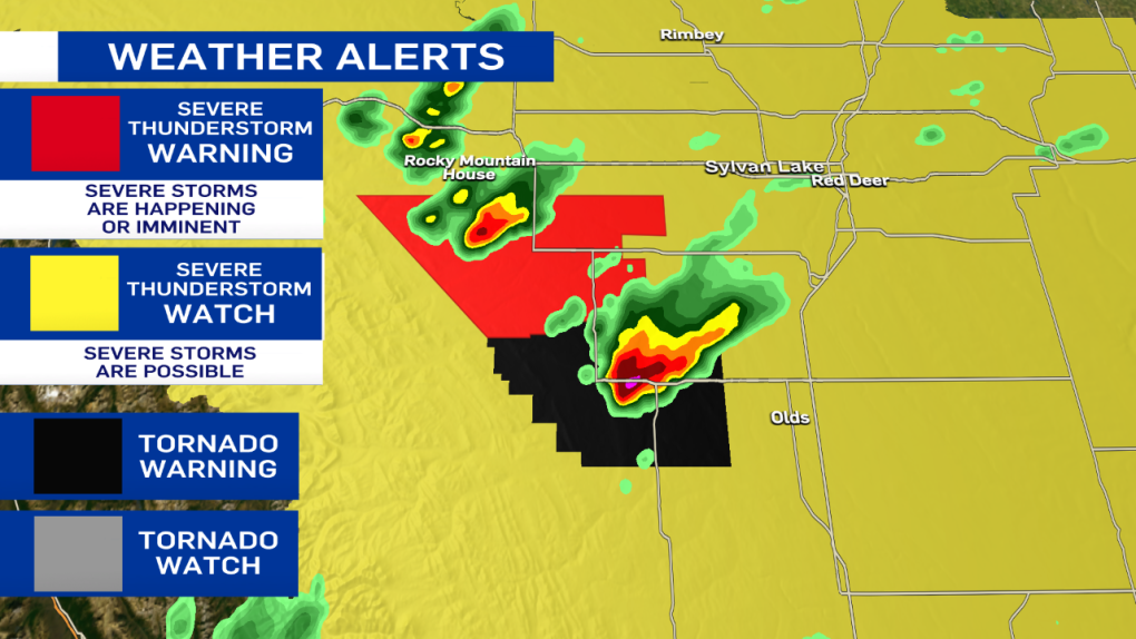
A Tornado WARNING remains in effect for areas SE of Sundre (where there has already been a tornado).
A Tornado WATCH remains in effect for the areas in grey on the map including the city of Red Deer.

Josh Classen at 3 p.m.:
A tornado WATCH is in effect for the areas in grey on the map. This means conditions are favourable for the development of severe thunderstorms that might produce a tornado.
A tornado WARNING remains in effect for a storm about 10 km south of Sundre. A tornado has been spotted near Bergen, and the storm is slowly moving ENE but remains a long way away from the QE2.
*** It's important to remember that most areas under a WATCH will not see any severe weather, but have the POTENTIAL for severe storms. Be aware of your surroundings, and stay tuned to weather alerts as they develop. The main threat of severe weather remains over areas south of the Edmonton region. The city sits on the northern end of the risk zone, and while severe storms are possible, they are far from guaranteed.

Josh Classen at 2:37 p.m.:
A tornado WARNING has been issued for areas near Sundre, and storm-chaser Kyle Brittain is in the area reporting a tornado touchdown near Bergen, just south of Sundre. The storm is SLOWLY moving NNE. People in that area should immediately seek shelter.
Josh Classen at 2:30 p.m.:
The Severe Thunderstorm WATCH area has extended further north to include Whitecourt/Mayerthorpe, Edson, Evansburg and areas just west of Edmonton, including Stony Plain and Spruce Grove. The city of Edmonton still isn't under an advisory. But, that may change later this afternoon as the storms continue to develop.

Josh Classen at 2:15 p.m.:
A small non-severe thunderstorm SW of Edmonton is moving NNE and should slide through western parts of the Edmonton metro region. The primary risk for powerful and possibly severe storms remains late this afternoon and early this evening.
A severe storm has developed west of Olds and is moving NE toward Bowden and Innisfail. Heavy rain and large hail are the main threats from this storm cell.
Another severe storm south of Edson is also likely producing hail as well as heavy downpours. This storm is moving also moving NE.
Cory Edel at 11:45 a.m.:
A Severe Thunderstorm Watch has now been issued by Environment Canada for areas just south and southwest of Edmonton.
Drayton Valley and Wetaskiwin are included in this watch area which extends south to the U.S. border. Conditions continue to ripen, with severe thunderstorms becoming more likely as we get into the late afternoon and evening.
Although Edmonton is not included in the Severe Thunderstorm Watch, that could change as storms start to develop and storm threat and path becomes clearer.
Remember, the dangers of severe thunderstorms include lightning, strong damaging winds and hail, along with heavy localized rain. In extreme cases, severe thunderstorms can produce tornadoes. If you find yourself in a situation with large storm clouds moving in, best to head inside until they pass through the area.
There is a saying, "When thunder roars, go indoors," a reminder that conditions could be changing quite quickly. Stay informed with us as we continue to follow this developing weather situation over Edmonton and central Alberta.
Cory Edel at 8 a.m.:
We're kicking off this Thursday with sun and cloud, seemingly quiet, but there is a good chance that will change as we head into the afternoon.
Today's weather conditions are favourable for the development of potentially severe thunderstorms through central areas of Alberta, including Edmonton.
These storms could produce large hail, strong wind and localized heavy rainfall.
With severe thunderstorms, there is also potential for tornado development. These storm cells could see some good rotation, and with that rotation and low level shear, the risk for tornadoes will be present later today. The greatest risk for this is south of the city, as Edmonton will be on the north-eastern edge of the severe storm risk area.
As far as timing, we will start to see some of these storms kick up off the foothills and pull to the northeast through the afternoon. For Edmonton, it's looking like we see the risk of the storms around the supper hour into the mid evening, about 5 p.m. to 9 p.m. If you are heading to the Edmonton Elks game tonight or have outdoor activities planned, it will be a good idea to be prepared to change your plans with this potentially fast-changing weather.
The storms will likely continue to pull to the east and northeast areas of the province later tonight and into the early morning hours. We will be keeping an eye on this developing severe-weather situation and follow up with any severe thunderstorm and possible tornado warnings issued by Environment Canada.
Join us on CTV News at 5 and 6 with Josh Classen as he tracks the development of these storms.


CTVNews.ca Top Stories

Indian envoy warns of 'big red line,' days after charges laid in Nijjar case
India's envoy to Canada insists relations between the two countries are positive overall, despite what he describes as 'a lot of noise.'
Former homicide detective explains how police will investigate shooting outside Drake's Bridle Path mansion
Footage from dozens of security cameras in the area of Drake’s Bridle Path mansion could be the key to identifying the suspect responsible for shooting and seriously injuring a security guard outside the rapper’s sprawling home early Tuesday morning, a former Toronto homicide detective says.
Stormy Daniels describes meeting Trump during occasionally graphic testimony in hush money trial
With Donald Trump sitting just feet away, Stormy Daniels testified Tuesday at the former president's hush money trial about a sexual encounter the porn actor says they had in 2006 that resulted in her being paid to keep silent during the presidential race 10 years later.
Alcohol believed to be a factor in boating incident after 2 men die: N.S. RCMP
Two Nova Scotia men are dead after a boat they were travelling in sank in the Annapolis River in Granville Centre, N.S., on Monday.
Northern Ont. woman makes 'eggstraordinary' find
A chicken farmer near Mattawa made an 'eggstraordinary' find Friday morning when she discovered one of her hens laid an egg close to three times the size of an average large chicken egg.
Susan Buckner, who played spirited cheerleader Patty Simcox in 'Grease,' dead at 72
Susan Buckner, best known for playing peppy Rydell High School cheerleader Patty Simcox in the 1978 classic movie musical 'Grease,' has died. She was 72.
Jeremy Skibicki has 'uphill battle' to prove he's not criminally responsible in Winnipeg killings: legal analysts
Accused killer Jeremy Skibicki could have a challenging time convincing a judge that he is not criminally responsible for the deaths of four Indigenous women, a legal analyst says.
Bye-bye bag fee: Calgary repeals single-use bylaw
A Calgary bylaw requiring businesses to charge a minimum bag fee and only provide single-use items when requested has officially been tossed.
CFL suspends Argos QB Chad Kelly at least nine games following investigation
The CFL suspended Toronto Argonauts quarterback Chad Kelly for at least nine regular-season games Tuesday following its investigation into a lawsuit filed by a former strength-and-conditioning coach against both the player and club.
Shopping Trends
The Shopping Trends team is independent of the journalists at CTV News. We may earn a commission when you use our links to shop. Read about us.


Calgary
-

Bye-bye bag fee: Calgary repeals single-use bylaw
A Calgary bylaw requiring businesses to charge a minimum bag fee and only provide single-use items when requested has officially been tossed.
-
Hospitals struggling as COVID-19 cases, hospitalizations rise in Alberta: doctor
COVID-19 statistics saw an uptick in late April in Alberta — a development one doctor says is straining hospitals even more.
-
Calgary Flames to pick 9th in 2024 NHL Draft
The Calgary Flames will be picking ninth overall in the 2024 National Hockey League (NHL) Draft.
Lethbridge
-

Heavy rain, strong winds cause downed trees, power outages across southern Alberta
As of Tuesday afternoon, between 21 and 31 millimetres of rain had fallen in the Lethbridge region since Monday evening.
-
Woman sought by Lethbridge police in gas station assault and robbery
A woman is being sought by Lethbridge police in connection with a robbery at a gas station that turned into an assault.
-
Lethbridge police seek suspects in 'street robbery'
Lethbridge police are looking for two people they believe were involved in the 'street robbery' of a senior last week.
Saskatoon
-

Saskatchewan care home where elderly man was allegedly attacked suspended after inspection
A Saskatchewan care home where an elderly man was allegedly attacked is suspended from taking on hospital patients following a recent inspection of the facility.
-
'Every one of these boxes is full of people': Saskatoon city archive moving to permanent home
It’s a new beginning for some of Saskatoon’s oldest and most significant pieces of history.
-
The lone road into this Sask. village is so bad some locals drive through the ditch
Aaron Fosseneuve says the official name of the road into his home community of Cumberland House is Highway 123, but locals joke it’s not as easy as 1-2-3 — “it’s more like a 4-5-6.”
Regina
-

Albert Street flood alert system causes confusion for commuters
On the same day the City of Regina activated its new flood warning system for the Albert Street underpass – drivers were faced with confusion when the system activated despite no flooding.
-
'They deserve a home': Regina Humane Society struggles to keep up with dog intake
The Regina Humane Society (RHS) is facing difficulties as the number of dogs in their care continue to increase.
-
Entertainment, mini donut eating contest and more coming to 2024 Queen City Ex
The countdown is now on for one Regina’s longest running events, the Queen City Ex (QCX).
Vancouver
-

B.C. court approves sale of Squamish-area ski resort development, despite government objections
Plans for a massive ski resort near Squamish, B.C., that have been in the works for more than two decades got a lifeline in the province's Supreme Court last week.
-
Canucks and Oilers fan rivalry heating up online on eve of Game 1
As the Vancouver Canucks and Edmonton Oilers prepare for the puck to drop on Game 1 of their second-round playoff series, fans of both teams are already cranking up the temperature with chirps on social media.
-
London Drugs reopens all stores across Western Canada after cyberattack
London Drugs says it has reopened all its stores across Western Canada after a cybersecurity breach forced the retailer to close last month.
Vancouver Island
-

Ottawa approves B.C.'s request to recriminalize drug use in public spaces
The federal government approved B.C.'s request Tuesday to recriminalize the use of drugs in public spaces such as hospitals and parks.
-
Grieving B.C. family seeks apology over paranormal TV show as network removes broadcast
The family of a teenage girl who died in Victoria says it’s traumatized by an episode of a TV show about the paranormal – and its complaints have now led to it being removed from APTN and APTNlumi.ca.
-
Military judge orders suspended jail sentence, $3K fine for B.C. sailor who stole from shipmates
A former Canadian navy sailor was handed a $3,000 fine and a suspended jail sentence Tuesday after pleading guilty to stealing thousands of dollars from his shipmates aboard a Pacific fleet frigate.
Toronto
-

Security guard shot, critically injured outside of Drake's Toronto mansion
A security guard working at Drake’s Bridle Path mansion in Toronto was seriously injured in a shooting outside the residence early Tuesday morning, police said.
-
How Drake and Kendrick Lamar's rap beef escalated within weeks
A long-simmering feud between hip-hop superstars Drake and Kendrick Lamar reached a boiling point in recent days as the pair traded increasingly personal insults on a succession of diss tracks. Here’s a quick overview of what’s behind the ongoing beef.
-
City reverses home run-ban at Toronto west-end baseball diamond
The City of Toronto is changing up its eyebrow-raising rules at a west-end baseball diamond.
Montreal
-

'Deeply disturbing' that Legault asked police to dismantle McGill encampment: opposition parties
Quebec Premier Francois Legault is facing criticism from opposition parties for asking police to dismantle the pro-Palestinian encampment on the McGill University campus.
-
Longtime weather specialist Lori Graham announces she's leaving CTV Montreal
CTV News Montreal's ray of sunshine — Lori Graham — is leaving the station after more than 25 years. The longtime weather specialist announced on Tuesday that she is saying goodbye to her CTV family to spend more time giving back to the community, specifically, her faith community on the South Shore.
-
Montreal Canadiens to get fifth overall pick in NHL draft
The Montreal Canadiens retained the fifth pick in the upcoming NHL lottery draft on Tuesday night.
Atlantic
-

Alcohol believed to be a factor in boating incident after 2 men die: N.S. RCMP
Two Nova Scotia men are dead after a boat they were travelling in sank in the Annapolis River in Granville Centre, N.S., on Monday.
-
Halifax Regional Police officer charged with assault against female he knows: SiRT
Nova Scotia's police watchdog says a Halifax Regional Police officer has been charged with assault.
-
Cape Breton residents raise concerns about rats
Some Cape Breton residents have seen a spike in rodent activities.
Winnipeg
-

Jeremy Skibicki has 'uphill battle' to prove he's not criminally responsible in Winnipeg killings: legal analysts
Accused killer Jeremy Skibicki could have a challenging time convincing a judge that he is not criminally responsible for the deaths of four Indigenous women, a legal analyst says.
-
'They've been increasing': Manitoba seeing an increase in number of ticks
This year's tick season is trending upward in Manitoba according to data and experts.
-
Taking a look at the Manitobans still in the Stanley Cup Playoffs
There are three Manitobans left, all playing for eastern teams in the Stanley Cup Playoffs – two with the Carolina Hurricanes and one with the Boston Bruins.
Ottawa
-

City of Ottawa will fly Israeli flag at City Hall on May 14 but won't hold flag raising ceremony
The flag of Israel will fly at Ottawa City Hall on May 14 to mark the country's Independence Day, but the City of Ottawa says it will not hold the customary flag-raising ceremony due to concerns about public safety.
-
Murder charge laid in Nepean student's stabbing death
Ottawa police have announced a murder charge in connection with the stabbing death of a 15-year-old in Nepean last week.
-
Ottawa Senators to select 7th overall in 2024 NHL Draft
The Ottawa Senators will have the seventh pick in the 2024 NHL Draft.
Northern Ontario
-
Security guard shot, critically injured outside of Drake's Toronto mansion
A security guard working at Drake’s Bridle Path mansion in Toronto was seriously injured in a shooting outside the residence early Tuesday morning, police said.
-
Northern Ont. woman makes 'eggstraordinary' find
A chicken farmer near Mattawa made an 'eggstraordinary' find Friday morning when she discovered one of her hens laid an egg close to three times the size of an average large chicken egg.
-
Man taken to Timmins hospital with gunshot wound after shooting on Sixth Avenue
People in Timmins are waking up to a heavy police presence and road closures in the area of Sixth Avenue and Pine Street on Tuesday morning.
Barrie
-

City aims to remove encampment in Barrie park
Barrie bylaw officers issued a violation notice to an individual who had set up an encampment in the vicinity of Milligan's Pond on Monday.
-
Casino Rama sets the stage for rock nostalgia with new concerts
Casino Rama Resort is amping up its 2024 entertainment lineup with three new rock performances, promising fans a nostalgic journey.
-
Police investigate suspicious death in Midland
Police are investigating a suspicious death that took place in the Town of Midland.
Kitchener
-

$9M in drugs seized by WRPS, two Kitchener residents charged
Two Kitchener residents are facing charges in what police are calling one of the largest drug seizures in the Waterloo Regional Police Services’ history.
-
OPP investigating alleged sexual assault at Fergus retailer
Wellington County Ontario Provincial Police say a woman was sexually assaulted by an unknown man at a Fergus retailer last week.
-
New charges for Ont. woman who previously admitted to defrauding doulas
The Brantford, Ont. woman who was previously sentenced to house arrest after admitting to deceiving doulas has been charged again in connection to a new victim.
London
-

'A recent onslaught': London, Ont. social service agency calls out city councillor’s social media campaign
A social service agency that offers support primarily geared to sex workers has written a pointed letter to London City Council, but appears to be focused on one council member in particular.
-
'I’d give them a one-way ticket out of here!' Sarnia councillor reacts in wake of police investigation at homeless encampment
The City of Sarnia will not clear out a homeless encampment in a city park anytime soon. The decision comes after a heated debate and multiple legal opinions — it also came just an hour before a serious stabbing occurred.
-
London, Ont. police undergoing changes in upper management
Weeks after a third deputy chief was sworn in, more changes are being made in upper management at London Police Service headquarters.
Windsor
-

Driver impaired by fentanyl sent to prison for 'devastating' death of Lakeshore woman
Trevor Hosie, 36, told the court he didn’t know the marijuana he consumed on May 6, 2023 was laced with a potent opioid. 'Sadly, this tragedy is the predictable outcome of the series of decisions made by Mr. Hosie on May 6, 2023,' Justice Christopher Uwagboe wrote in his sentence decision.
-
Severe thunderstorm watch issued for Windsor, Ont.
A severe thunderstorm watch has been issued for the Windsor region early Tuesday evening.
-
'Shine a light on a dark situation': Lakeshore, Ont. woman plans run to raise funds for ovarian cancer
An ovarian cancer diagnosis and treatment can bring darkness frustration and uncertainty. But a Lakeshore mother of two who is now cancer-free is planning to mark the milestone by trying to help others.


