After hitting a record-setting 10.1 degrees on Tuesday, Edmonton settles in around 0 today.
Temperatures should hold steady in the 0 to 2 degree range for most of the late morning & early afternoon.
By the way...that 10.1 yesterday wasn't just a record for February 9th (it beat the old mark of 10.0 set in 1928).
Yesterday was the first time since 2006 that we had a double-digit day in February (without a minus sign).
The last time it was hotter in February than yesterday was when Edmonton hit 11 degrees on February 12, 2006
That heat is gone for a little while. We'll remain warmer than average, but not record-setting warm.
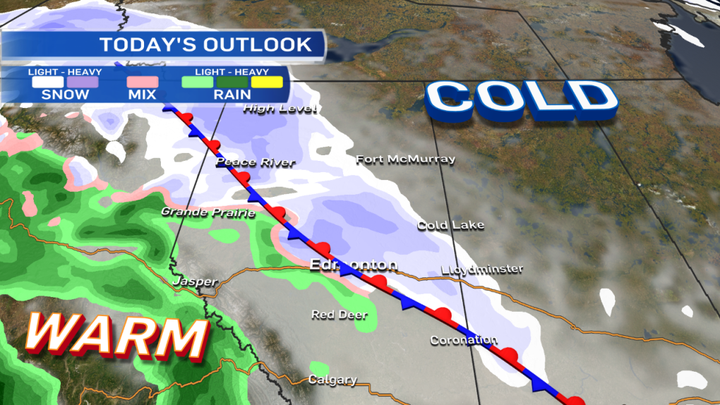
The arctic front (which was up in N & NE Alberta yesterday) drops back to the SW today & ends up very close to the Capital Region.
Along that front, we'll have some precipitation later today & early Thursday.
Most of the heavier snow is expected to stay north & east of Edmonton.
Areas from Slave Lake SE to Vegreville could get 5-10cm of snow by midday Thursday.
From the Peace Country E to Lac La Biche & SE to Wainwright...1-5cm is possible.
Edmonton is on the southern edge of that risk.
This could end up being one of those situations where N & NE parts of the Capital Region wake up to a couple cm of snow & the south side gets nothing.
We should have a better handle on the position of the front later today. So...stay tuned.
Until then...I've added a risk of 1-5cm of snow into the forecast for the Edmonton area tonight.
The other aspect we'll need to watch is the risk of rain & freezing rain in some areas.
The Grande Prairie region looks to have the highest potential for freezing rain this evening.
Again...more on that situation as the day develops.
LONG-RANGE Outlook:
After a couple cooler days today, Thu & Fri...temperatures are expected to bounce back into the 4-8 degree range for the weekend.
Here's the Edmonton forecast:
Today - Mostly cloudy.
High: 2
Tonight - 60% chance of light snow. 1-5cm possible.
Risk of a rain/snow mix or patchy freezing rain.
Evening: -2
Thursday - 40% chance of flurries in the morning. Cloudy with a 30% chance of flurries in the afternoon.
Morning Low: -6
Afternoon High: 1
Friday - Mostly cloudy.
Morning Low: -5
Afternoon High: 0
Saturday - Mix of sun & cloud.
Morning Low: -2
Afternoon High: 5
Sunday - Partly cloudy.
Morning Low: -1
Afternoon High: 6
Monday - Mix of sun & cloud.
Morning Low: -2
Aftenoon High: 6
Advertisement
COOLER & A CHANCE OF SNOW - February 10, 2016
CTV Edmonton
Published Wednesday, February 10, 2016 8:59AM MST
Published Wednesday, February 10, 2016 8:59AM MST
