Heavy rain is set to fall on west-central Alberta over the next few days.
Most of Edmonton's rain will fall early Wednesday.
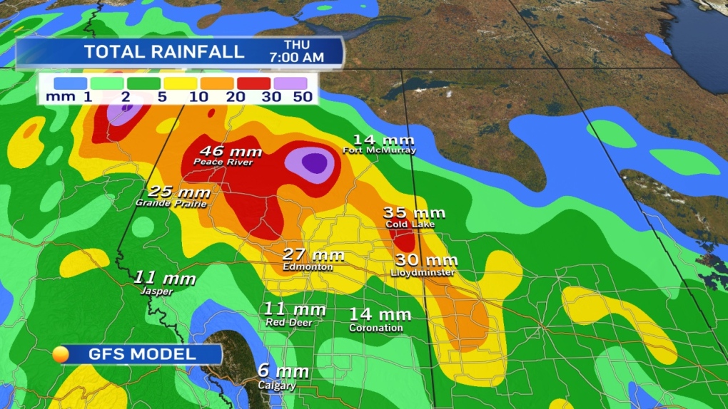
The attached map is the GFS model's total cumulative rainfall between now & Thursday morning (when it finally tapers off).
The GEM model has that red "bulls-eye" of heaviest precipitation a little further SW (Whitecourt to Rocky Mtn House).
Given the setup, I'd expect some of the heaviest rain to fall in that area west of Edmonton.
30-60mm looks possible in that region from Rocky Mtn House to Whitecourt, with the chance of some snow in a few areas within that zone.
Environment Canada issued a "Special Weather Statement" this morning re: the heavy rain.
Expect Rainfall WARNINGs to be issued later today.
Once this system rolls in, it'll stay with us until late Thursday.
Along with the rain, there's a risk of heavy snow developing in the foothills & parts of NW Alberta.
We're REALLY close to the rain-snow line in many areas.
Most regions should see it remain as snow, but a few areas could wake up to some wet snow on the ground Thursday morning.
I'll be watching the Grande Prairie region closely. GFS model has the rain turning to heavy snow by Wednesday afternoon.
For now, I just have rain with a "risk of snow" in the forecast for that area.
In Edmonton, gusty & heavy rain tomorrow. SLIGHT risk of some wet flurries mixed in with the rain Wednesday night/early Thursday morning.
Heaviest rain falls Wednesday morning, then it eases Wednesday afternoon.
Cooler air drops in for Thu/Fri/Sat.
Warmer temperatures return early next week.
Here's the Edmonton forecast:
Today - Increasing cloud this morning.
Wind becoming E 20 gusting to 40 this afternoon.
High: 17
Tonight - Cloudy. Rain starting overnight.
Wind easing overnight.
Low: 6
Wednesday - Cloudy with periods of rain. 20-30mm
Heaviest rain in the morning, tapering off to light rain in the afternoon.
Wind becoming WNW 30 gusting to 60km/h mid-morning.
30 gusting to 50 in the afternoon.
High: 8
Risk of rain turning to wet snow overnight.
Thursday - 60% chance of rain or wet snow in the morning.
Cloudy in the afternoon.
Morning Low: 1
Afternoon High: 6
Friday - Mostly cloudy.
Morning Low: 0
Afternoon High: 6
Saturday - Mostly cloudy. 30% chance of a shower.
Morning Low: 0
Afternoon High: 5
Sunday - Cloudy with sunny breaks.
Morning Low: 1
Afternoon High: 10
Advertisement
HERE COMES THE RAIN! - APRIL 22, 2014
CTV Edmonton
Published Tuesday, April 22, 2014 7:47AM MDT
Published Tuesday, April 22, 2014 7:47AM MDT
