After a warm Monday, it was a snowy night in Central & NW Alberta.
The Capital Region has 1-3cm of new snow on the ground this morning.
Elsewhere, it appears 5-10cm of snow hit the Peace Country late yesterday & last night.
Get used to shovelling. There's a lot more snow on the way.
And this time...it'll be accompanied by some COLD, Arctic air.
In the Capital Region, the area of widespread light snow will taper off to: "occasional pockets of light flurries" this afternoon.
Temperatures will fall to the -10 range this afternoon & then to the mid minus teens overnight.
We're cloudy & cool Wednesday as we await Thursday's snowstorm.
A broad area of low pressure out the Pacific will start to haul some moisture along the jetstream into W & S Alberta Wednesday night.
Meanwhile, cold air will start to spill out of the NWT as an Arctic High pressure system drops in.
Where the moisture collides with the cold, we'll get HEAVY SNOW!
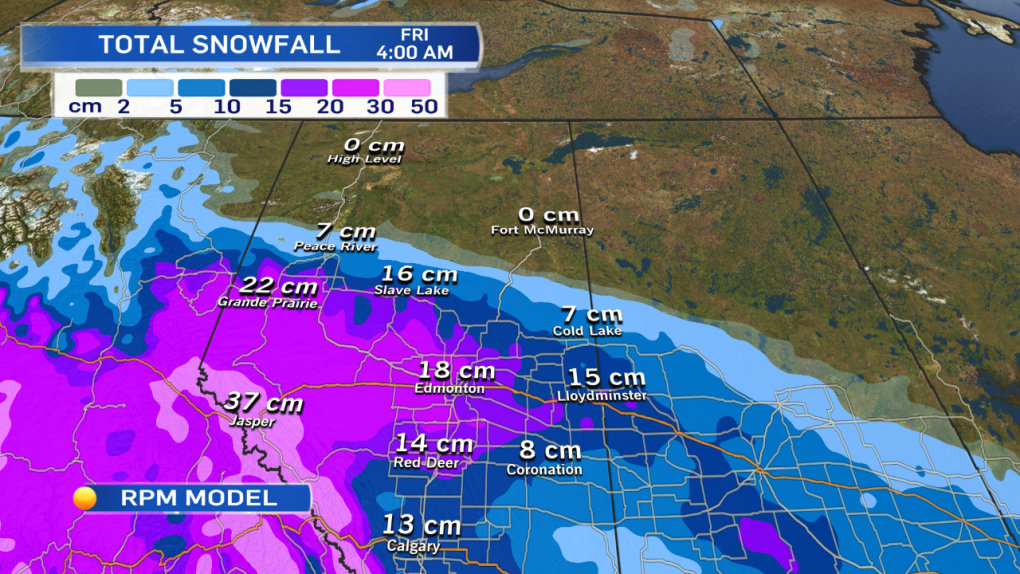
On the attached map, you can see that the RPM model is projecting about 20cm of snow in Grande Prairie, "almost" 20cm in Edmonton & about 15cm for Red Deer & the Lloydminster regions.
In Jasper, 30-40cm is possible.
It should be pointed out that the GFS model has even HIGHER projected snowfall totals. It's projecting 30cm in Grande Prairie, 26cm in Edmonton, 23cm in Red Deer & 67cm in Jasper!
So, there's still some uncertainty with how MUCH snow will fall. I think the GFS might be overdoing it, though.
The other uncertainty is exactly WHERE the heaviest snow will fall...
There's still time for that storm path to change.
IF the Arctic High moves south sooner or further than expected, or if it lags back to the north, THAT could change the storm track a bit.
But, that would only affect locations at the edges of the snow track.
I don't see a way that this misses Edmonton.
The Capital Region is getting snow (starting Wednesday night & finishing Friday morning)
The only real question is: "How much?"
10-20cm is a pretty wide range, but that's about the best estimate we can give for right now.
After the snow, it's sunny & cold for the weekend with daytime highs near -20 Saturday & Sunday.
Here's the Edmonton forecast:
Today - Cloudy with light snow this morning.
Cloudy with a few occasional flurries this afternoon.
5pm: -11
Tonight - Cloudy. A few light flurries.
Low: -15
Wednesday - Cloudy. Snow starting Wednesday evening.
High: -7
Thursday - Periods of snow. Heavy at times.
10-20cm possible.
Temperature falling through the day.
Morning: -12
Afternoon: -15
Friday - Cloudy with a few flurries.
Morning Low: -19
Afternoon High: -16
Saturday - Partly cloudy.
Morning Low: -26
Afternoon High: -20
Advertisement
MORE SNOW AND AN ARCTIC BLAST - November 25, 2014
CTV Edmonton
Published Tuesday, November 25, 2014 7:38AM MST
Published Tuesday, November 25, 2014 7:38AM MST
