

Timeline for Friday's storm system across Alberta
 A wall cloud forms west of Wetaskiwin, Alta., on Friday, July 8, 2022 (Source: ArmyStormChaser/Twitter
Severe thunderstorms are once again moving through central Alberta. Here are updates from CTV News Edmonton's chief meteorologist Josh Classen.
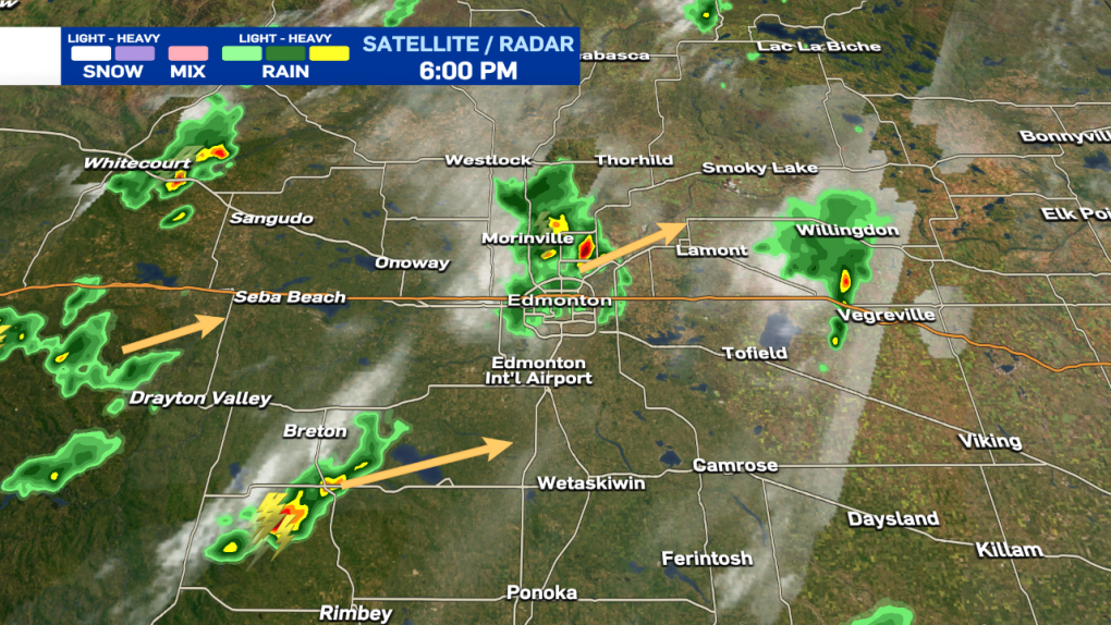
Josh Classen at 6:00 p.m.:
While the severe thunderstorm WATCH remains in effect for the City of Edmonton, the risk of severe weather is very low.
Some light rain is falling on parts of the city (looks like the SE might get completely missed). Heavier rain north of Edmonton is moving NE.
The next chance for precipitation is a slight risk of seeing the showers/thunderstorms south of Breton or the ones NW of Drayton Valley. If those do appear likely to hit the area, we'll send another update. Otherwise, this will be the end of today's updates. Thanks for following along.
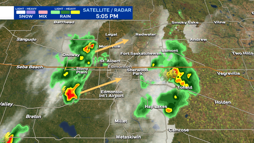
Josh Classen at 5:10 p.m.:
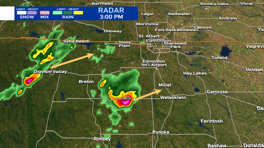
A line of rain with two storm cells at either end of it are moving NE into the Edmonton region. These are non-severe storms but still producing some heavier downpours and strong wind gusts. The risk of hail is relatively low. The storms will quickly move through.
Josh Classen at 4:40 p.m.:
The thunderstorm that passed through the Wetaskiwin region has weakened, and the warning has ended for that area. Still expect rain, lightning and wind as it pushes through the Hay Lakes area.
A weak thunderstorm popped up over Sherwood Park and dumped some heavy rain there, but that has quickly moved east.
The best chance for a thunderstorm in Edmonton remains around 5:30-8 pm as the broken line of showers and isolated thunderstorms west of the city moves in.
That system includes a storm NE of Breton that is likely producing hail (as well as HEAVY rain).
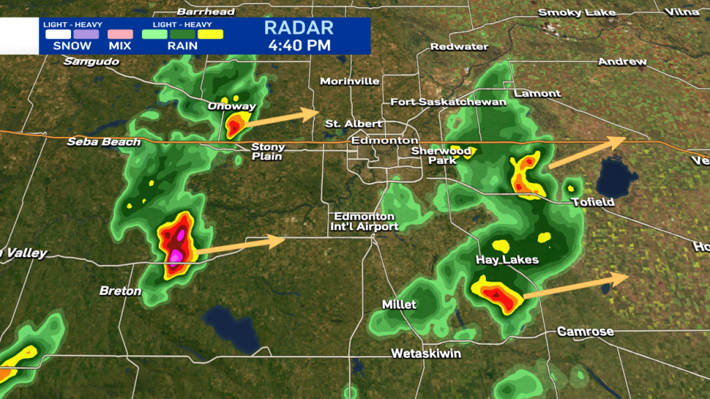
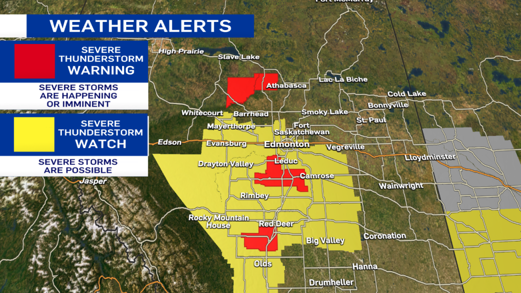
Here are the current warnings and watches as of 4:40 pm
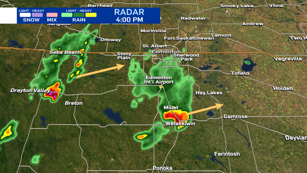
Josh Classen at 4:00 p.m.:
The severe storm near Wetaskiwin and Millet is weakening a bit, but still producing heavy rain and possibly some small hail. This storm will stay south of Edmonton as it moves NE.
However, there's a bit of rain falling on parts of south Edmonton on the northern edge of this cell. The best chance for a storm over Edmonton will come later this afternoon/early evening as the broken line from Drayton Valley to Lake Wabamun moves further east.
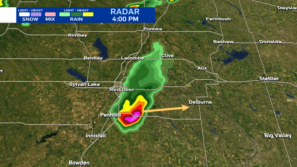
Severe storm SE of Red Deer continues to show signs of hail (possibly large hail) and heavy downpours. It's heading ENE towards the Delburne area.
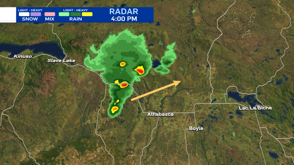
Severe storm NW of Athabasca is moving NE and will likely stay north of Athabasca.
Also of note - lots of lightning showing up west of Fort McMurray, but that storm system will likely stay well to the west of Fort McMurray as it moves NE. That region COULD see some activity late tonight as the Athabasca-area storms move NE.
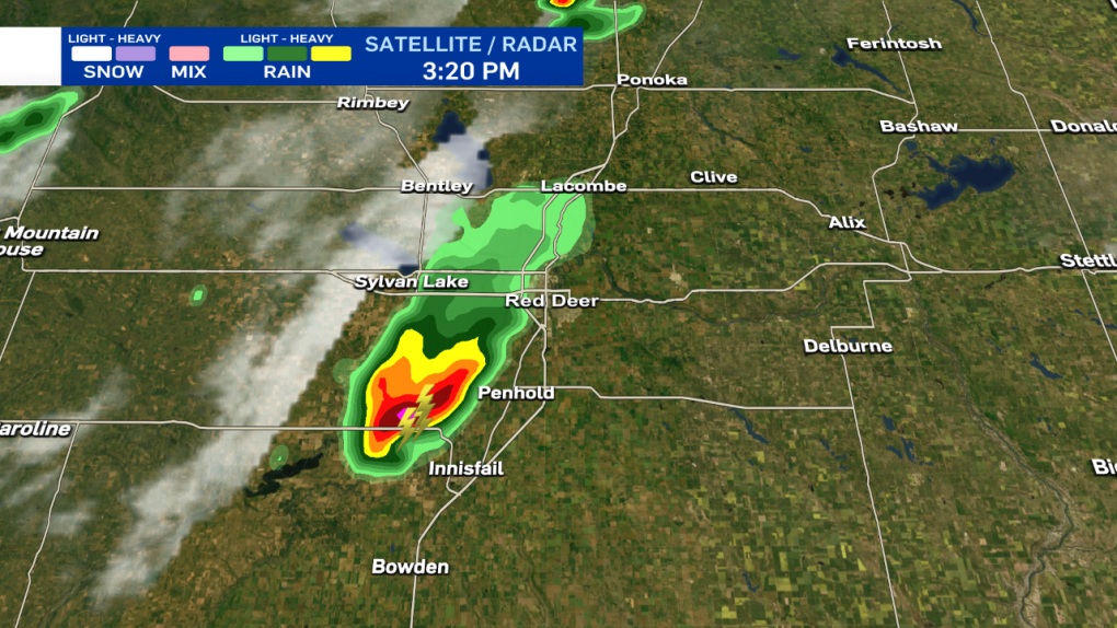
Josh Classen at 3:25 p.m.:
A severe thunderstorm warning is in effect for this storm cross the QE2 and heading east towards Wetaskiwin. LOTS of lightning, HEAVY rain and probably hail (possibly up to nickel-sized).
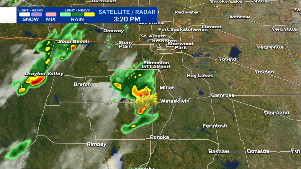
A severe thunderstorm west of Penhold and Innisfail has less lightning, but IS producing HEAVY rain and is showing signs of some broad rotation on radar. It's moving east at approx 30 km/h.
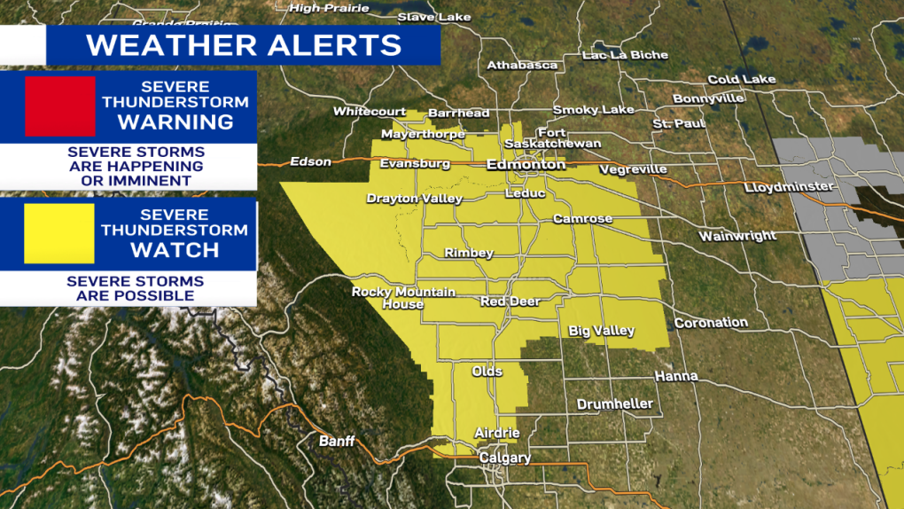
Josh Classen at 3:00 p.m.:
Friday's storms are a lot fewer and farther between. Plus, the tornado risk has moved east into Saskatchewan today. The city of Edmonton and all areas in yellow on the map below are under a Severe Thunderstorm WATCH (possibly severe thunderstorms).
The areas in red are under Severe Thunderstorm WARNINGs and are either currently or imminently seeing severe weather. The main threats from these storms are localized downpours, hail (possibly up to nickel-sized) and strong wind gusts.
Most (possibly all) of the severe storms will pass south of the Edmonton area. But, there is a chance of some showers and thunderstorms late this afternoon and early this evening. (possibly as early as 4 p.m. for the SW corner of the city).
AND...although the risk is low, we can't rule out the chance of a severe storm late this afternoon.


CTVNews.ca Top Stories

W5 Investigates
W5 Investigates Car security investigation: How W5 'stole' a car using a device we ordered online
In part two of a three-part series into how thieves are able to drive off with modern vehicles so easily, CTV W5 correspondent Jon Woodward uses a device flagged by police to easily clone a car key.
Satire slinger The Onion buys Alex Jones' Infowars at auction with help from Sandy Hook families
The satirical news publication The Onion won the bidding for Alex Jones' Infowars at a bankruptcy auction, backed by families of Sandy Hook Elementary School shooting victims whom Jones owes more than $1 billion in defamation judgments for calling the massacre a hoax, the families announced Thursday.
South African government says it won't help 4,000 illegal miners inside a closed mine
South Africa's government says it will not help an estimated 4,000 illegal miners inside a closed mine in the country's North West province who have been denied access to basic supplies as part of an official strategy against illegal mining.
Trump hammered Democrats on transgender issues. Now the party is at odds on a response
After losing the White House and both houses of Congress, Democrats are grappling with how to handle transgender politics and policy following a campaign that featured withering and often misleading GOP attacks on the issue.
EU slaps Meta with a nearly $1.2 billion fine for engaging in 'abusive' Marketplace practices
European Union regulators issued their first antitrust fine to Facebook parent Meta on Thursday with a penalty of nearly 800 million euros for what they call 'abusive practices' involving its Marketplace online classified ads business.
B.C. Realtors fined $200K for failure to disclose relevant information to clients
Two B.C. real estate agents have been fined a combined total of more than $200,000 for professional misconduct they committed during the sale of a waterfront property on the Sunshine Coast in 2017.
India's 'most wanted terrorist' arrested in Canada
One of India's most wanted terrorists has been arrested and charged in connection with a recent alleged shooting in Ontario.
More than 800 million adults have diabetes globally, many untreated, study suggests
More than 800 million adults have diabetes worldwide – almost twice as many as previous estimates have suggested – and more than half of those aged over 30 who have the condition are not receiving treatment, according to a new study.
opinion
opinion Why the new U.S. administration won't have much time for us
In a column for CTVNews.ca, former Conservative Party political advisor and strategist Rudy Husny says that when Prime Minister Justin Trudeau goes to the G-20 summit next week, it will look more like his goodbye tour.
Shopping Trends
The Shopping Trends team is independent of the journalists at CTV News. We may earn a commission when you use our links to shop. Read about us.


Calgary
-

Serious crash closes intersection near Drumheller
Drivers are being asked to avoid the scene of a serious crash near Drumheller, Alta.
-
45 cats, 2 dogs rescued from northern Alberta property by Calgary aid agency
Dozens of cats and two dogs have been rescued from rural property by a Calgary-based animal charity.
-
RCMP to announce update to body-worn camera program
RCMP are expected to share details about a nation-wide rollout of a body-worn camera project from Ottawa, the same devices that Calgary police officers have been using for years.
Lethbridge
-
Serious crash closes intersection near Drumheller
Drivers are being asked to avoid the scene of a serious crash near Drumheller, Alta.
-
Lethbridge police say multiple arrests made following 'high-risk incident'
Lethbridge police say a number of arrests have been made following an investigation on Thursday morning.
-
Charges laid in Lethbridge carjacking that saw truck, police cruiser end up in canal
Lethbridge police have charged two people in connection with a weekend carjacking that saw a stolen vehicle driven dangerously throughout the city.
Saskatoon
-

Cynthia Block will be Saskatoon's next mayor
Cynthia Block is the 29th mayor of Saskatoon, and the first woman elected to the position in the city's history.
-
Prince Albert elects new mayor after 12 years under Greg Dionne
After 12 years under Greg Dionne, the City of Prince Albert has a new mayor.
-
Assault charge against former Sask. private school employee dropped
A private school employee accused of hitting a seven-year-old student in the head with a relay baton had her assault charge dropped on Wednesday in Saskatoon provincial court.
Regina
-

Chad Bachynski defeats Sandra Masters to become mayor of Regina
Chad Bachynski will be Regina's next mayor, after defeating incumbent Sandra Masters, who was vying for a second term.
-
Here's a look at Regina's projected new city council
Regina's projected new city council will consist of eight new members with more than a handful of outgoing councillors not seeking re-election and two incumbents being defeated Wednesday night.
-
Civic election results from around southern Saskatchewan
Wednesday, Nov. 13 saw a wave of civic elections across southern Saskatchewan with victories and upsets all over. Here are the preliminary results for some of the smaller urban centres.
Vancouver
-

Public invited to sign condolences book for former B.C. premier John Horgan
The public is being invited to share messages in memory of late B.C. premier John Horgan this week.
-
B.C. woman who 'carried on' as mortgage broker, sent falsified documents ordered to pay $35K
A woman from B.C.'s Lower Mainland has been handed a $35,000 penalty after admitting she "carried on" as a mortgage broker in the preparation of 10 mortgage applications, despite lacking the necessary registration.
-
Pedestrian struck, seriously injured in New Westminster
A pedestrian was injured after being hit by a vehicle Wednesday afternoon in New Westminster, police say.
Vancouver Island
-

B.C. woman who 'carried on' as mortgage broker, sent falsified documents ordered to pay $35K
A woman from B.C.'s Lower Mainland has been handed a $35,000 penalty after admitting she "carried on" as a mortgage broker in the preparation of 10 mortgage applications, despite lacking the necessary registration.
-
Class-action alleges abuse, cultural devastation at Canadian Indigenous group homes
A proposed class-action lawsuit against the Canadian government says Indigenous people removed from their communities and placed in group homes beginning in the 1950s suffered physical, sexual and psychological abuse that "was commonplace, condoned and, arguably, encouraged."
-
Push to name new university in Langford, B.C., after John Horgan
A push is on to permanently memorialize B.C.'s former premier, the man known to many as 'John from Langford,' in the Vancouver Island city.
Toronto
-

Police release bodycam video of officer-involved incident at Hindu temple protest
Police say an officer who forcefully removed a 'weapon' from a protester outside of a Hindu temple in Brampton was acting 'within the lawful execution of his duties' after bystander video of the incident circulated widely online.
-
LIVE UPDATES: Taylor Swift in Toronto for first of 6 sold-out shows
Taylor Swift is in Toronto to perform her first of six sold-out shows at the Rogers Centre tonight.
-
Teen arrested during West Queen West gun battle was wanted in deadly Etobicoke home invasion: police
A teenage boy arrested along with more than 20 others following a gun battle in Toronto’s West Queen West neighbourhood was wanted in connection with a deadly home invasion in Etobicoke back in April, Toronto police say.
Montreal
-

Police, firefighters respond to train derailment near Montreal; no injuries reported
Police are responding to a derailment at a train yard in Longueuil, Que., on Montreal’s South Shore.
-
REM: Service launch in 2025 and upcoming interruptions
The Caisse de dépôt is now aiming for fall 2025 for the launch of the Deux-Montagnes and Anse-à-l'Orme branches of the Réseau express métropolitain (REM), while new cost overruns are expected and voluntary interruptions will take place in the coming months.
-
Quebec to audit 17 schools on secularism law compliance
The Quebec government will audit 17 schools to make sure they respect secularism, in the wake of citizen complaints.
Atlantic
-
 NEW
NEWNEW Tim Hortons gift card brouhaha shows N.S. electoral officer needs fining power: watchdog
The director of a democracy watchdog says that if Nova Scotia's electoral officer had more power to levy fines, it would discourage situations such as campaign managers giving Tim Hortons gift cards to voters.
-
N.S. election: Liberals promise to improve cellphone service and highways
Nova Scotia's Liberal party is promising to improve cellphone service and invest in major highways if the party is elected to govern on Nov. 26.
-
Halifax's QEII emergency department damaged after sprinkler activated
The emergency department at the QEII Health Sciences Centre in Halifax sustained damage over the weekend after a sprinkler was activated.
Winnipeg
-

Crash on Chief Peguis causing Thursday morning traffic delays
A crash on Chief Peguis Trail is causing Thursday morning traffic delays.
-
Manitoba Crown stays sexual assault charges against priest on second day of trial
The Crown has stayed sex charges against a Roman Catholic priest in Manitoba on the second day of his trial.
-
'Something to look forward to': Roughriders fan cheering for Bombers in Australia
CFL fans down under are preparing to take in the Grey Cup – Canadian style.
Ottawa
-
 COMING UP @ 1 PM
COMING UP @ 1 PM Ottawa Police to provide update on ‘Project Champion’
Ottawa Police are set to provide information Thursday about an 18-month investigation that concluded this week.
-
Toronto man charged with uttering threats towards an Ottawa medical clinic, police say
An 18-year-old Toronto man is facing charges after allegedly making hundreds of threats towards a medical clinic operating in the Ottawa suburb of Orleans.
-
Trump border czar calls eastern Ontario border crossing an 'extreme' security vulnerability
U.S. president-elect Donald Trump's incoming border czar is calling one of Canada's busiest border crossings in eastern Ontario an "extreme vulnerability" for the United States as he intends to crack down on illegal immigration and increase border agents across the U.S.-Canada border.
Northern Ontario
-

South African government says it won't help 4,000 illegal miners inside a closed mine
South Africa's government says it will not help an estimated 4,000 illegal miners inside a closed mine in the country's North West province who have been denied access to basic supplies as part of an official strategy against illegal mining.
-
'Your body, my choice': Attacks on women surge on social media following U.S. election
Sexist and abusive attacks on women, like 'your body, my choice' and 'get back to the kitchen,' have surged across social media since Trump’s reelection.
-
Northern Ontario couple charged in their baby girl's 2022 death
A northern Ontario couple has been charged in the death of their three-month-old baby girl who was found in September 2022 with no vital signs.
Barrie
-

Police investigation near Bradford public school an isolated incident
Police say officers apprehended someone in the vicinity of a Bradford elementary school on Thursday morning, but confirmed the incident had nothing to do with the school.
-
Sinkhole forced lengthy closure of Highway 400 ramp in Barrie
A Highway 400 exit ramp in Barrie was closed for nearly 24 hours following reports of a sinkhole.
-
Police called to home after resident finds unexpected visitor
One Barrie resident was faced with an unexpected surprise after their return home on Tuesday night.
Kitchener
-

Take a look inside Amazon’s new fulfillment centre in Cambridge, Ont.
Amazon says its new fulfillment centre in Cambridge, Ont. is the first-of-its-kind in the country.
-
Toronto teenager charged with first-degree murder in Kitchener, Ont. homicide
A Toronto teen has been charged as part of an investigation into Kitchener, Ont.’s first homicide of 2024.
-
Kitchener, Ont. woman with incurable cancer dies, fight continues to get provincial funding for expensive drug treatment
The family of a young Kitchener woman, who died Sunday from a rare bile duct cancer, is promising her quest to get provincial funding for a drug that helped extend her life will continue.
London
-

Concerns remain as Hydro One identifies a preferred corridor for the St. Thomas EV battery plant
Hydro One has identified a preferred route for a transmission corridor to supply the Volkswagen electric vehicle battery plant in St. Thomas, Ont. While the corridor now appears inevitable, officials are continuing to take feedback on the plan.
-
Needleless insulin device being introduced in Canada on World Diabetes Day
“InsuJet [is] the first device to Canada that actually has no needles,” said Daphne Lapenna of Sol-Millennium Medical Ltd. who is introducing the product to Canada on Thursday evening at Banting House.
-
W5 Investigates
W5 Investigates Car security investigation: How W5 'stole' a car using a device we ordered online
In part two of a three-part series into how thieves are able to drive off with modern vehicles so easily, CTV W5 correspondent Jon Woodward uses a device flagged by police to easily clone a car key.
Windsor
-

Mangy foxes 'will not survive': A cry for help
A Windsor resident is asking for the public’s help to capture two injured foxes roaming in the east end of the city.
-
Man busted going over double the speed limit: LaSalle police
LaSalle police have charged a 43-year-old man with stunt driving after allegedly going over double the speed limit.
-
Body recovered from Detroit River
The LaSalle Police Service has recovered a body from the Detroit River.


