Josh Classen's forecast: Here comes a cooldown

Temperatures should get to 20 or 21 C in Edmonton this afternoon. But, this'll probably be our last 20-something day until late next week.
We FINALLY got a decent thunderstorm in the city Wednesday night and there might be a bit more precip before the end of the weekend.
Those are the main weather stories as we head into this final weekend of summer: cooler temperatures and MAYBE a bit more precipitation.
The Autumn equinox is next Thursday (Sept. 22). That'll actually coincide with a return to warmer temperatures. But, more on that in a minute.
Thursday night's thunderstorm "officially" brought 5-10 mm of rain to the city.
The 5.9 mm measured at the Blatchford weather station was the most since Aug. 4 had 12.1 mm.
The only other days since the start of August with more than 2 mm of rain are Aug. 5 (5.1 mm) and Aug 27 (4.8 mm).
Now...after saying all that...we DO have some "unofficial" stations scattered around the city and some of those picked up significantly more than the Blatchford and EIA rain gauges.
- AM transmitter (just south of Sherwood Park): 12 mm
- FM transmitter (Windermere / SW Edmonton): 17 mm
- CTV Edmonton studio (184 Street and Stony Plain Rd): 8 mm
- South end of St Albert: 3 mm
- Northeast Edmonton: 2 mm
OK, back to the forecast...
We'll see a low-pressure system develop in southern Alberta today. Instead of moving east, that system will drive north.
So...the heaviest, and steadiest precipitation is going to develop in west and northwest Alberta, particularly in the northwest.
Areas from around Grande Prairie southeast towards Edson and Whitecourt could pick up anywhere between 15 to 40 mm with even higher amounts possible in some spots.
West and northwest of Grande Prairie could get well over 50 mm of rain by the end of Saturday.
Areas near Fort McMurray will get some soaking rain Saturday night into early Sunday with 20+ mm possible.
Edmonton's on the edge of the precipitation-risk zone. There's a chance we'll get a shower or thunderstorm late this evening and/or overnight.
We may also have a few scattered showers in the area (particularly western parts of the region) early Saturday.
But...the bulk of the precipitation will avoid the city.
Daytime highs drop to the mid to upper teens for Saturday/Sunday in Edmonton as some cooler air moves in and then the upper trough REALLY digs south early next week.
We're in for the coolest stretch of days since early May. Afternoon highs in the 10 to 15 C range for Monday-Wednesday.
Mornings will get close to 0 C, especially Wednesday/Thursday.
BUT...we're right back to highs near 20 C by the end of next week.
Here's the forecast for Edmonton and area:
Today - Partly cloudy this morning. Increasing cloud this afternoon.
High: 21
Tonight - Mostly cloudy. 30% chance of a shower or thunderstorm late this evening and/or overnight.
9pm: 15
Saturday - Mostly cloudy in the morning with a 30% chance of showers.
Clearing in the afternoon.
Morning Low: 8
Afternoon High: 16
Sunday - Mix of sun & cloud.
Morning Low: 6
Afternoon High: 18
Monday - Mix of sun & cloud. 30% chance of showers.
Morning Low: 6
Afternoon High: 14
Tuesday - Mix of sun & cloud. 30% chance of showers or periods of light rain.
Morning Low: 5
Afternoon High: 12
Wednesday - Partly cloudy.
Morning Low: 3
Afternoon High: 14
CTVNews.ca Top Stories
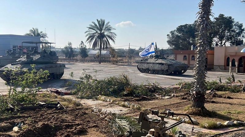
BREAKING Israeli forces seize Rafah border crossing in Gaza, putting ceasefire talks on knife's edge
Israeli tanks seized control of Gaza’s vital Rafah border crossing on Tuesday as Israel brushed off urgent warnings from close allies and moved into the southern city even as ceasefire negotiations with Hamas remained on a knife’s edge.
Mediterranean staple may lower your risk of death from dementia, study finds
A daily spoonful of olive oil could lower your risk of dying from dementia, according to a new study by Harvard scientists.
Winnipeg man admits to killing four women, argues he's not criminally responsible
Defence lawyers of Jeremy Skibicki have admitted in court the accused killed four Indigenous women, but argues he is not criminally responsible for the deaths by way of mental disorder – this latest development has triggered a judge-alone trial rather than a jury trial.
An El Nino-less summer is coming. Here's what that could mean for Canada
As Canadians brace themselves for summer temperatures, forecasters say a weakening El Nino cycle doesn’t mean relief from the heat.
Man banned from owning animals after fatal Calgary dog attack
The owner of three Calgary dogs that got loose and mauled a woman to death in 2022 has been ordered to pay a $15,000 fine within one year and banned from owning any animal for 15 years.
Have you been removed from your family doctor’s patient list for visiting an Ontario walk-in clinic?
Some Ontarians are expressing frustration after they said that they were removed from their family doctor’s patient list for visiting a walk-in clinic in a process being called “de-rostering.”
East-end Ottawa family dealing with massive rat infestation
Residents in Ottawa’s Elmridge Gardens complex are dealing with a rat infestation that just won’t go away. Now, after doing everything they can to try to fix the issue, they are pleading with the city to step in and help.
Canadian government proposes new foreign influence registry as part of wide-spanning new bill
Prime Minister Justin Trudeau's government is proposing a suite of new measures and law changes aimed at countering foreign interference in Canada, amid extensive scrutiny over past meddling attempts and an ever-evolving threat landscape.
Boeing Starliner capsule's first crewed test flight postponed
The long-awaited first crewed test flight of Boeing's new Starliner space capsule was called off for at least 24 hours over a technical issue that launch teams were unable to resolve in time for the planned Monday night lift-off.


