Thunderstorms pass through Edmonton, Red Deer and west-central Alberta
 Lightning seen in Beaver County north of Tofield, Alta., on June 11, 2024. (Submitted: Brenda Carlson)
It was a beautiful spring day in Edmonton, but it's ending on a stormy note.
Severe thunderstorms that developed over the city late Tuesday afternoon and brought wind, rain and lightning have moved off to the east-northeast, with the threat of severe storms ending for the time being.
As of 7 p.m. Tuesday, Environment and Climate Change Canada (ECCC) had ended the severe thunderstorm warning for Edmonton and area and kept the city, St. Albert and Sherwood Park under a thunderstorm watch alert.
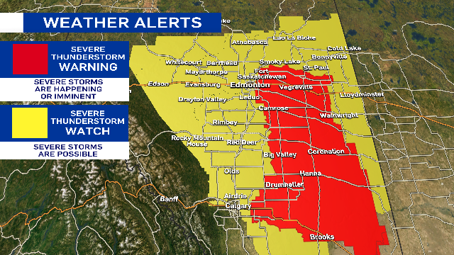
ECCC had issued a severe thunderstorm warning at 5:15 p.m. for Edmonton and area as well as regions of the city south along Highway 2 through Red Deer and Calgary.
Earlier severe thunderstorm warnings for areas near Red Deer, Olds, Grande Cache, Botten, Amundson and Alder Flats have also ended.
The Edmonton region will continue to see rain and a few non-severe thundershowers early in the evening. The potential exists for a few more thunderstorms to redevelop mid-evening.
Cloudy, wet, windy and cool conditions will take over on Wednesday with gusts in the 40-50 km/h range through most of the day in Edmonton.
Rain may be in the area for much of the day, but the morning will likely be wetter than the afternoon.
A severe thunderstorm 'warning' means the severe storms are occurring or imminent, while a 'watch' means potential for severe weather.
 A severe thunderstorm warning on June 11, 2024, in Edmonton and area ended early in the evening as storms moved east-northeast of the city. (Josh Classen/CTV News Edmonton)
High over 20 C, clouds develop in afternoon, thunderstorms
For the second consecutive day, we got into the low 20s in Edmonton.
Sunshine and light wind early in the day gave way to increasing afternoon cloud then thunderstorms.
Edmonton's had back-to-back 20-degree days just a few times this spring:
- May 9/10
- May 27/28
- June 1/2
And there are no three or four-days stretches in the 20s.
That trend will continue as cooler air settles in for Wednesday.
The heaviest, steadiest rain will be in east-central/northeast Alberta.
Here's the forecast for Edmonton and area:
Wednesday - Cloudy with periods of light rain.
Wind: WNW 30 gusting to 50 km/h
Morning Low: 11
Afternoon High: 14
Thursday - Cloudy in the morning, clearing in the afternoon.
Morning Low: 9
Afternoon High: 19
Friday - Partly cloudy. 30% chance of an evening shower/thunderstorm.
Morning Low: 11
Afternoon High: 22
Saturday - Mix of sun & cloud. 30% chance of a late-day shower.
Morning Low: 11
Afternoon High: 19
Sunday - Mostly cloudy. 40% chance of showers.
Morning Low: 9
Afternoon High: 16
CTVNews.ca Top Stories

Winter storms, wind and freezing rain: Hazardous conditions expected in some parts of Canada
Hazardous conditions are expected in some parts of Canada this week.
BoC expected to lower interest rates again, with odds leaning toward larger cut
Financial markets and forecasters are betting on another jumbo interest rate cut from the Bank of Canada this week.
The Canada Post strike involving more than 55,000 has hit 25 days
The Canada Post strike involving more than 55,000 workers has hit 25 days.
Police search for three men who escaped from immigration holding centre in Quebec
Authorities are searching for three Chilean nationals who escaped from the Laval Immigration Holding Centre north of Montreal.
Celebrities spotted at Taylor Swift's final Eras Tour performance in Vancouver
Taylor Swift fans from around the world gathered in Vancouver on Sunday to witness the final performance of her massively popular Eras Tour, including a few celebrities.
Sask. hockey player recovering after near fatal skate accident during game
The Sask East Hockey League (SEHL) has released details of a near fatal accident at one of its games over the weekend – which saw a Churchbridge Imperials player suffer serious injuries after being struck with a skate.
Government faces third Tory non-confidence vote ahead of potential fiscal hurdle
The Liberals are set to face a third Conservative non-confidence vote today, but the government is likely to survive with the support of the NDP.
U.S. should be concerned about illegal immigration from Canada: Canadian survey
More than 80 per cent of Canadians believe the flow of illegal immigrants from Canada to the U.S. is a concern, according to a new survey.
Jay-Z denies allegations he sexually assaulted a 13-year-old in 2000 with Sean 'Diddy' Combs
A woman who alleges she was sexually assaulted by Sean 'Diddy' Combs has amended her lawsuit to include allegations that she was also assaulted by Jay-Z at the same party.


