Heavy snow set to hit central and northeast Alberta

Edmonton and area will likely have between 5 and 15 centimetres of fresh snow on the ground by midday Tuesday.
A Snowfall Warning has been issued by Environment and Climate Change Canada and that warning zone stretches from Rocky Mountain House northeast towards Fort McMurray.
In general, most of the warning zone will get 5 to 10 cm of snow. But, there will be heavier bands from around Edmonton off to the east and northeast where 15+ centimetres is possible.
The timing for Edmonton and area has the heavier snow starting overnight and carrying through into the early morning hours of Tuesday before tapering off late in the morning.
The morning commute will definitely be affected with the heavy, fresh snow on the ground. But, wind doesn't look like it'll be stronger than 10-15 km/h. So, blowing snow shouldn't be too much of an issue.
Areas further west will see the snow end earlier while eastern and northeastern Alberta may see the snow last through to early Wednesday.
Here are some forecast models for estimated snowfall totals up to the end of the day Tuesday.
Regions like Fort McMurray could see a further 5 to 10 cm of snow by the end this snow event Wednesday.
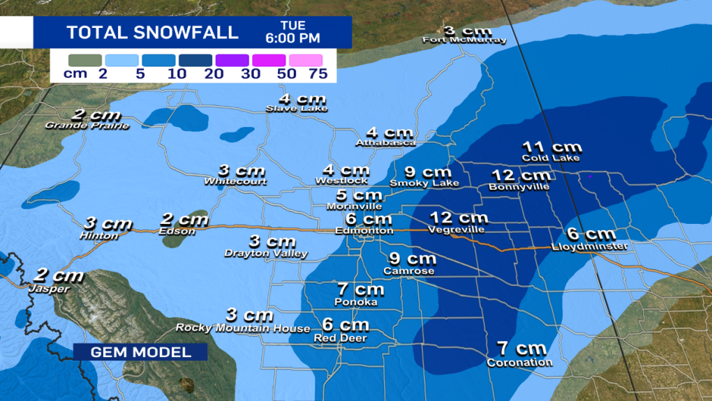
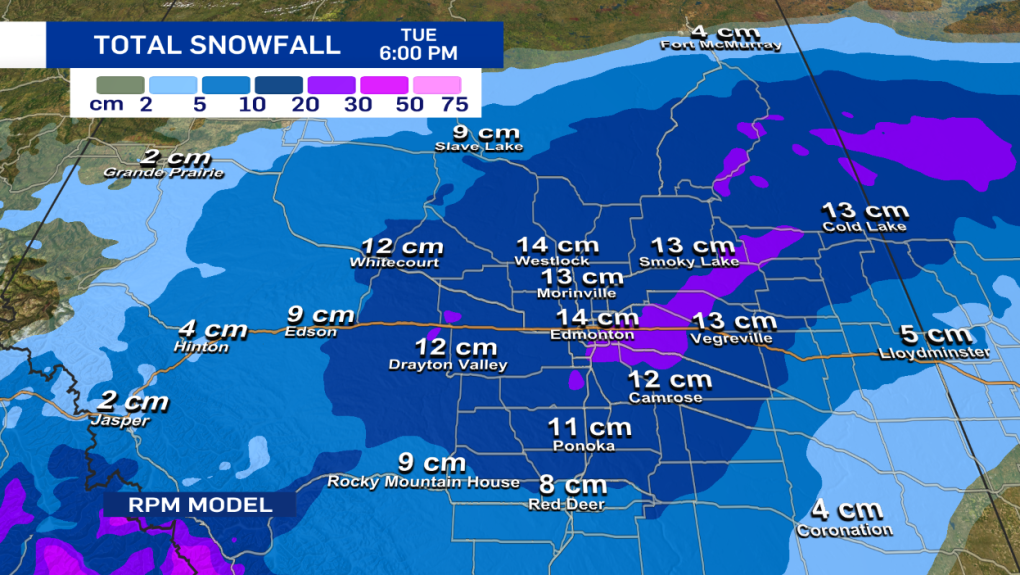
You'll notice the GEM has significantly less snow for Edmonton and keeps the heavier totals to the east. The RPM, meanwhile, has the heaviest band stretching back further to the west to include Edmonton.
This is why we've gone with such a wide forecast range of 5 to 15 cm for the city.


CTVNews.ca Top Stories

'A beautiful soul': Funeral held for baby boy killed in wrong-way crash on Highway 401
A funeral was held on Wednesday for a three-month-old boy who died after being involved in a wrong-way crash on Highway 401 in Whitby last week.
Police handcuff man trying to enter Drake's Toronto mansion
Toronto police say a man was taken into custody outside Drake's Bridle Path mansion Wednesday afternoon after he tried to gain access to the residence.
Biden says he will stop sending bombs and artillery shells to Israel if they launch major invasion of Rafah
U.S. President Joe Biden said for the first time Wednesday he would halt shipments of American weapons to Israel, which he acknowledged have been used to kill civilians in Gaza, if Prime Minister Benjamin Netanyahu orders a major invasion of the city of Rafah.
U.S. presidential candidate RFK Jr. had a brain worm, has recovered, campaign says
Independent U.S. presidential candidate Robert F. Kennedy Jr. had a parasite in his brain more than a decade ago, but has fully recovered, his campaign said, after the New York Times reported about the ailment.
Ontario Provincial Police arrest 64 suspects in child sexual exploitation investigation
Ontario Provincial Police say 64 suspects are facing a combined 348 charges in connection with a series of child sexual exploitation investigations that spanned the province.
Pfizer agrees to settle more than 10K lawsuits over Zantac cancer risk: Bloomberg News
Pfizer has agreed to settle more than 10,000 lawsuits about cancer risks related to the now discontinued heartburn drug Zantac, Bloomberg News reported on Wednesday, citing people familiar with the deal.
Quebec premier defends new museum on Quebecois nation after Indigenous criticism
Quebec Premier Francois Legault is defending his comments about a new history museum after he was accused by a prominent First Nations group of trying to erase their history.
Blind Sask. boy heading to international braille competition hopes to increase accessibility for visually impaired
A Saskatchewan boy who qualified for an international braille competition in Los Angeles next month hopes he can inspire change in his home province.
'A step forward': New screening criteria for sperm donors takes effect
Canadians looking to grow their families with the assistance of sperm or egg donations should soon have more options for donors as the federal health agency does away with longstanding restrictions criticized as discriminatory.
Shopping Trends
The Shopping Trends team is independent of the journalists at CTV News. We may earn a commission when you use our links to shop. Read about us.


Calgary
-

Calgary man charged with sexual assault of Cowboys patron
Calgary police have charged a man with the sexual assault of a woman he met at a downtown club.
-
Improving psycho-educational assessment access in Alberta the focus of new bill
Alberta parents, teachers and the official opposition are pushing for better provincial access to psycho-educational assessments for students.
-
Is it 'Anybody but Edmonton' for Flames fans as the Oilers take on the Canucks?
Will Flames fans jump on the Connor McDavid bandwagon and support the Oilers as they take on the Canucks?
Lethbridge
-

Brooks Bandits getting ready for BCHL Alberta division finals
It took seven games, but the Brooks Bandits were able to knock off the Okotoks Oilers in the BCHL Alberta division semi-finals. After a hard-fought series, the Bandits are feeling battle-tested.
-
Here's what you can expect at Lethbridge's Whoop-Up Days 2024
Lethbridge's largest festival will get underway in four months, with a variety of new and returning attractions.
-
Northbound lane closed along Aquitania Blvd in Lethbridge
A lane closure was announced by the City of Lethbridge Wednesday.
Saskatoon
-

'Written off': Sask. woman says her brother, who had Down syndrome, fell through the cracks
Tara Jo Kadlec has been advocating for better care for her brother Cory for years.
-
From CTV's archive: Watch the Regina Pats score 17 goals in one 1985 playoff game against the Blades
There have been some crazy WHL playoff games over the years. But a team scoring 17 goals? In one game?
-
Toronto man charged in Saskatchewan after police seize cocaine, cash and a Glock
A Toronto man faces drug trafficking charges in Saskatchewan after police in Prince Albert seized nearly 100 grams of cocaine, cash, and a Glock handgun on Tuesday.
Regina
-

'Lax environment' contributed to 2020 deaths of 2 SaskPower workers
A Saskatchewan judge has found SaskPower guilty of three workplace-safety related violations over an incident that left two workers dead in Weyburn.
-
From CTV's archive: Watch the Regina Pats score 17 goals in one 1985 playoff game against the Blades
There have been some crazy WHL playoff games over the years. But a team scoring 17 goals? In one game?
-
Speed limit to be lowered in Regina's Cathedral neighbourhood
The speed limit in Regina’s Cathedral neighbourhood will be lowered to 40 kilometres per hour after city council voted in favour of the reduction Wednesday afternoon.
Vancouver
-

B.C. theatre to pay $55K to neurodivergent actor in discrimination case
British Columbia's human rights tribunal has awarded a neurodigergent actor, who was diagnosed with sensory and learning disorders, more than $55,000 after finding that a Kelowna theatre company discriminated against him because of his disabilities.
-
Woman arrested after suspicious fire at Roadhouse Grille in Surrey, RCMP say
A suspicious fire at the Roadhouse Grille is one of several "criminal acts" under investigation in South Surrey this week, according to the RCMP.
-
Crown appeals not guilty verdict in crash that killed toddler
Crown prosecutors are appealing a not-guilty verdict in a tragic case where a driver struck and killed a toddler on a downtown Vancouver sidewalk.
Vancouver Island
-
B.C. theatre to pay $55K to neurodivergent actor in discrimination case
British Columbia's human rights tribunal has awarded a neurodigergent actor, who was diagnosed with sensory and learning disorders, more than $55,000 after finding that a Kelowna theatre company discriminated against him because of his disabilities.
-
TSB releases report into fatal Vancouver Island floatplane crash
A floatplane crash that killed two people on the west coast of Vancouver Island last summer was caused by a collision with a boat wake or an object in the water, according to an investigation report published by the Transportation Safety Board of Canada Wednesday.
-
Rookie goalie Arturs Silovs to start for Canucks in Game 1 vs. Oilers
Rookie goalie Arturs Silovs will start in net for the Canucks as Vancouver kicks off a second-round series against the Edmonton Oilers Wednesday night.
Toronto
-
Police handcuff man trying to enter Drake's Toronto mansion
Toronto police say a man was taken into custody outside Drake's Bridle Path mansion Wednesday afternoon after he tried to gain access to the residence.
-
'A beautiful soul': Funeral held for baby boy killed in wrong-way crash on Highway 401
A funeral was held on Wednesday for a three-month-old boy who died after being involved in a wrong-way crash on Highway 401 in Whitby last week.
-
Ontario Provincial Police arrest 64 suspects in child sexual exploitation investigation
Ontario Provincial Police say 64 suspects are facing a combined 348 charges in connection with a series of child sexual exploitation investigations that spanned the province.
Montreal
-

English CEGEPs struggling with requirements under Bill 96; French language minister says it's necessary
Quebec's minister for the French language says if English CEGEPs are having a problem with the new French-language exam for students, it only shows that the province's language laws are necessary.
-
No more doctor's note: Quebec bill would scrap paperwork for massages, medical equipment
On Wednesday, Labour Minister Jean Boulet announced that he will table a bill to cut red tape, so that family doctors can free up an additional 500,000 medical appointments for patients each year by a plan to put an end to require a medical note in order to be reimbursed by an insurance company.
-
WATCH THE VIDEO
WATCH THE VIDEO Actor Gouchy Boy charged with assaulting Montreal photographer before sentencing on sex assault
A Quebec actor known as Gouchy Boy was charged with assaulting a photographer at a Montreal-area courthouse Wednesday minutes before he was sentenced for sexual assault.
Atlantic
-

Halifax police looking for missing woman, child from Quebec
Halifax Regional Police is looking for a missing 26-year-old woman and a six-year-old child from Quebec.
-
Pilot project for three-wheeled vehicles to start in Nova Scotia soon
A pilot project to test and evaluate the operation of federally-approved three-wheeled vehicles on Nova Scotia roads starts next week.
-
Premier Higgs announces new N.B. environment minister
New Brunswick Premier Blaine Higgs has named a new minister of environment and climate change nearly three weeks after the previous one resigned from the post over political disagreements.
Winnipeg
-
'I killed four people': Trial hears video evidence of Jeremy Skibicki at Winnipeg trial
“I killed four people,” alleged serial killer Jeremy Skibicki told two homicide detectives during a recorded interview played as evidence in his trial Wednesday.
-
'A great, great honour': Manitoban's photograph selected for Canada Post stamp
The sumptuous sights of the Manitoba Sunflower Festival are set to make their way around the world thanks to a Winnipeg photographer.
-
Proposed class-action lawsuit launched against Manitoba government for use of solitary confinement in prisons
A proposed class-action lawsuit has been filed against the Manitoba government by a previous inmate for the use of solitary confinement, calling the practice, "cruel, inhumane, and degrading treatment."
Ottawa
-

High school student fatally stabbed in Nepean remembered as 'beloved' son
A 15-year-old who was fatally stabbed last week is being remembered as a "beloved son, brother, cousin, nephew, grandson and friend."
-
'Summer of discontent': Federal unions vow to fight new 3-day a week office mandate
Federal unions are launching legal challenges and encouraging public sector workers to file "tens of thousands" of grievances over the new mandate requiring federal workers to return to the office at least three days a week in the fall.
-
Attempted murder charges laid in Overbrook apartment fire
The Ottawa Police Service has laid charges against an Ottawa man, including for attempted murder, in connection with an alleged arson of an Overbrook apartment building last week.
Northern Ontario
-
Seven northern Ont. men busted in huge online child exploitation investigation
A province-wide child sexual abuse investigation by Ontario Provincial Police dubbed Project Aquatic has resulted in hundreds of charges, including seven male suspects from northern Ontario.
-
'Ozempic babies': Reports of surprise pregnancies raise new questions about weight loss drugs
Numerous women have shared stories of 'Ozempic babies' on social media. But the joy some experience in discovering pregnancies may come with anxiety about the unknowns.
-
Ontario man devastated to learn $150,000 line of credit isn't insured after wife dies
An Ontario man found out that a line of credit he thought was insured actually isn't after his wife of 50 years died.
Barrie
-

Barrie business owner fed up over repeated break-ins since opening
A small business owner in Barrie is fed up after his establishment has been the target of crime multiple times since opening in 2019.
-
Crown seeks 6 years jail time for Barrie woman guilty of impaired driving causing bodily harm
An emotional Cassie Korzenko walked into the Barrie Courthouse Wednesday morning with family members by her side ahead of a sentencing hearing.
-
14-year-old charged after high school lockdown
A 14-year-old from Orillia has been charged with mischief after a threat was made toward an Orillia high school on Wednesday.
Kitchener
-

64 people charged in Ontario child exploitation investigations
Ontario Provincial Police say 64 people have been arrested and a combined 348 charges have been laid in connection with a series of child exploitation investigations that spanned across the province.
-
Brantford, Ont. pharmacy already seeing demand for weight loss drug Wegovy
Wegovy, from the company behind Ozempic, is now available across Canada. We stopped by a Brantford pharmacy to learn more about the drug.
-
Residents from 250 Frederick Street rally against renovictions at Kitchener City Hall
Residents from 250 Frederick St. in Kitchener have been at odds with the building’s new owner for months.
London
-

More than 150 townhomes in northeast London have lost mail service due to off-leash dog
‘It’s a rough situation.’ Townhome residents on Briarhill Avenue have been without mail deliver for about two months.
-
Mother testifies in own defence at disturbing child abuse trial
The mother involved in a shocking child abuse case in London, Ont. took the stand on Wednesday, denying that she ever harmed her children.
-
TSB concludes investigation into cause of London, Ont. freight train fire
More than two weeks after a freight train with several railcars ablaze rolled through the heart of the Forest City, the Transportation Safety Board (TSB) has concluded its investigation.
Windsor
-

'Predators go where children go': 5 local people arrested, charged through Project Aquatic
Four people from Windsor, one of whom is 16 years old, and one person from Chatham are now charged with offences including possessing, accessing and making available child pornography.
-
'I wouldn’t trade it for anything': Caesars Windsor celebrates 30 years in the community
To celebrate their 30-year presence in the Windsor community, Caesars Windsor employees are rolling up their sleeves this week, volunteering at six local non-profit organizations.
-
Death deemed not suspicious after body found near Tecumseh Mall
Windsor police say the death was not suspicious after a body was found near an east Windsor mall.


