Thunderstorms pass through Edmonton, Red Deer and west-central Alberta
 Lightning seen in Beaver County north of Tofield, Alta., on June 11, 2024. (Submitted: Brenda Carlson)
It was a beautiful spring day in Edmonton, but it's ending on a stormy note.
Severe thunderstorms that developed over the city late Tuesday afternoon and brought wind, rain and lightning have moved off to the east-northeast, with the threat of severe storms ending for the time being.
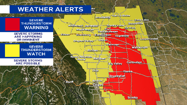
As of 7 p.m. Tuesday, Environment and Climate Change Canada (ECCC) had ended the severe thunderstorm warning for Edmonton and area and kept the city, St. Albert and Sherwood Park under a thunderstorm watch alert.
ECCC had issued a severe thunderstorm warning at 5:15 p.m. for Edmonton and area as well as regions of the city south along Highway 2 through Red Deer and Calgary.
Earlier severe thunderstorm warnings for areas near Red Deer, Olds, Grande Cache, Botten, Amundson and Alder Flats have also ended.
The Edmonton region will continue to see rain and a few non-severe thundershowers early in the evening. The potential exists for a few more thunderstorms to redevelop mid-evening.
Cloudy, wet, windy and cool conditions will take over on Wednesday with gusts in the 40-50 km/h range through most of the day in Edmonton.
Rain may be in the area for much of the day, but the morning will likely be wetter than the afternoon.
A severe thunderstorm 'warning' means the severe storms are occurring or imminent, while a 'watch' means potential for severe weather.
 A severe thunderstorm warning on June 11, 2024, in Edmonton and area ended early in the evening as storms moved east-northeast of the city. (Josh Classen/CTV News Edmonton)
High over 20 C, clouds develop in afternoon, thunderstorms
For the second consecutive day, we got into the low 20s in Edmonton.
Sunshine and light wind early in the day gave way to increasing afternoon cloud then thunderstorms.
Edmonton's had back-to-back 20-degree days just a few times this spring:
- May 9/10
- May 27/28
- June 1/2
And there are no three or four-days stretches in the 20s.
That trend will continue as cooler air settles in for Wednesday.
The heaviest, steadiest rain will be in east-central/northeast Alberta.
Here's the forecast for Edmonton and area:
Wednesday - Cloudy with periods of light rain.
Wind: WNW 30 gusting to 50 km/h
Morning Low: 11
Afternoon High: 14
Thursday - Cloudy in the morning, clearing in the afternoon.
Morning Low: 9
Afternoon High: 19
Friday - Partly cloudy. 30% chance of an evening shower/thunderstorm.
Morning Low: 11
Afternoon High: 22
Saturday - Mix of sun & cloud. 30% chance of a late-day shower.
Morning Low: 11
Afternoon High: 19
Sunday - Mostly cloudy. 40% chance of showers.
Morning Low: 9
Afternoon High: 16


CTVNews.ca Top Stories

Oilers force Game 7 of Stanley Cup final with 5-1 win over Panthers
The Oilers are one win from history. The Panthers are one loss from infamy. Zach Hyman scored his playoff-leading 16th goal and Stuart Skinner made 20 saves as Edmonton defeated Florida 5-1 on Friday to force Game 7 in the Stanley Cup final.
Where is Louis Riel? Heritage Minute of Métis leader quietly removed
A decision to quietly remove a decades-old Heritage Minute on Louis Riel has left some in the Métis community scratching their heads, as questions are raised about how Canada's history is portrayed.
Heritage minister views next election as a referendum on Canadian cultural reforms
Minister of Canadian Heritage Pascale St-Onge says the next federal election could become a referendum on Canadian culture and the trio of legislative measures the Liberals have advanced to try to protect it.
Billionaire businessman James K. Irving dead at 96
The family of Canadian billionaire businessman James K. Irving has announced his death at the age of 96, just over a month after the death of his younger brother, Arthur.
'Reckless in the extreme': Lamborghini driver convicted for crash while passing Toronto streetcar
A Lamborghini driver who tried to pass a Toronto streetcar at three times the speed limit, striking several parked cars and totalling his own vehicle, has been found guilty of dangerous driving causing bodily harm.
Pedestrian killed on Hwy. 97 following bus crash that caused 'numerous' injuries
A pedestrian was struck and killed on Highway 97 in the B.C. Interior early Friday afternoon as emergency crews were responding a school bus crash that caused “numerous” injuries to those on board.
4 people found dead in southwestern Ontario town of Harrow
Ontario Provincial Police are investigating after four people were found dead in the town of Harrow, just south of Windsor. Officers were called to a residence on County Road 13 at approximately 1:30 p.m. on Thursday.
4 members of a billionaire family get prison in Switzerland for exploiting domestic workers
An Indian-born billionaire and three family members were sentenced to prison on Friday for exploiting domestic workers at their lakeside villa in Switzerland by seizing their passports, barring them from going out and making them work up to 18 hours a day.
MP Marco Mendicino spat on by man in Ottawa
A video circulating online shows MP and former cabinet minister Marco Mendicino get spat on while on his way into a government building in Ottawa.
Shopping Trends
The Shopping Trends team is independent of the journalists at CTV News. We may earn a commission when you use our links to shop. Read about us.


Calgary
-

'It takes away my independence': Alberta woman speaks out against provincial law that prohibits use of her mobility scooter
An Olds, Alta., woman with accessibility issues is speaking out against the town after local bylaw officers informed her she would receive a $5,000 fine if she was caught using her mobility scooter on any street, sidewalk or pathway in town.
-
Gondek urges Calgarians to keep water usage down amid hot weekend weather
Calgary Mayor Jyoti Gondek is asking people to continue conserving water this weekend, warning the hot weather might make it tempting to ignore the restrictions.
-
As it happened: Oilers win 5-1, force Game 7 in Stanley Cup Final
We're going to Game 7. The Edmonton Oilers beat the Florida Panthers 5-1 at Rogers Place on Friday night with goals from Warren Foegele, Adam Henrique, Zach Hyman, Ryan McLeod and Darnell Nurse to even the Stanley Cup Final at 3-3.
Lethbridge
-

Lethbridge celebrates National Indigenous Peoples Day
National Indigenous People’s Day celebrations got an early start today.
-
Game 6 of Stanley Cup Final gets the big screen treatment in Lethbridge
The resurgence of the Oilers in the NHL finals might be a tough pill for hockey fans in Calgary to swallow, but down in Lethbridge, they’re giving Friday night’s Game 6 the big screen treatment.
-
Hikers injured in Waterton bear attack out of hospital, bear not yet located
Parks officials say two hikers injured in an Alberta bear attack last week are now out of hospital.
Saskatoon
-

Saskatoon 'Rock Your Roots' Walk breaks personal record with thousands attendees
A sea of orange stretched as far as the eye could see along Saskatoon's riverfront as a record-breaking 5,000-plus people took part in the 'Rock Your Roots' Walk on Friday.
-
Sask. woman dies at hospital following vehicle crash
An 83-year-old woman who was involved in a collision last week has died from her injuries.
-
Melfort doctor accused of spanking child and striking another in the face
A Melfort doctor is facing a series of charges from the Saskatchewan College of Physicians and Surgeons, which alleges he hit children on two separate occasions.
Regina
-

National Indigenous People's Day celebrated in Regina
Thousands of people in Regina turned out to Victoria Park on Friday for National Indigenous People's Day.
-
New City of Regina ward boundaries in the hands of Sask. judge
A Court of King’s Bench judge is now weighing whether or not the Saskatchewan Municipal Board (SMB) and the City of Regina followed the correct steps while implementing the city’s new ward boundaries.
-
Tornado warning near Davidson, Sask. lifted
A tornado warning that was in effect for the rural municipality of Willner near the Town of Davidson, Sask. has since been lifted.
Vancouver
-

Pedestrian killed on Hwy. 97 following bus crash that caused 'numerous' injuries
A pedestrian was struck and killed on Highway 97 in the B.C. Interior early Friday afternoon as emergency crews were responding a school bus crash that caused “numerous” injuries to those on board.
-
Union says social worker staffing at 'crisis' levels in B.C.
The union representing social workers is raising the alarm about staffing levels in B.C.
-
B.C. First Nations involved in salmon farming demand apology from William Shatner, Ryan Reynolds
A coalition of B.C. First Nations involved in open-net salmon farming have called on Canadian actors William Shatner and Ryan Reynolds to apologize for a profanity-laced video criticizing the wider industry.
Vancouver Island
-
Pedestrian killed on Hwy. 97 following bus crash that caused 'numerous' injuries
A pedestrian was struck and killed on Highway 97 in the B.C. Interior early Friday afternoon as emergency crews were responding a school bus crash that caused “numerous” injuries to those on board.
-
Union says social worker staffing at 'crisis' levels in B.C.
The union representing social workers is raising the alarm about staffing levels in B.C.
-
Drivers remain in hospital, witness sought following crash in Nanaimo, B.C.
Two people remain in hospital Friday after a serious crash in Nanaimo, B.C., was caused when a wrong-way driver collided with a transport truck earlier this week, according to police.
Toronto
-

'Anxious about the future': Some job seekers in the Greater Toronto Area struggling to find work amid high unemployment rate
Hundreds of thousands of people in Toronto are either unemployed or underemployed. CTV News Toronto spoke with job seekers in the Toronto area who were looking for work amid the relatively high unemployment rate. Here are a few of those conversations, as well as advice from experts on how to improve your chances of landing a full-time job.
-
'Discarded in the freezer': Owners reeling after death of 2 dogs under care of Toronto area petsitter
After seeing her dog's body removed from a freezer a day after leaving him in the care of a petsitter, Jenuen Monroe wants answers.
-
'Reckless in the extreme': Lamborghini driver convicted for crash while passing Toronto streetcar
A Lamborghini driver who tried to pass a Toronto streetcar at three times the speed limit, striking several parked cars and totalling his own vehicle, has been found guilty of dangerous driving causing bodily harm.
Montreal
-

June heat wave takes it toll on Quebec strawberry crops
Strawberry farmers in Quebec are in damage control after this week's extreme heat soured the beloved summertime fruit.
-
'Historic victory': Judge orders Quebec to pay taxi drivers $143 million
A Superior Court judge has ordered the Quebec government to pay taxi drivers $143 million in compensation for its decision to abolish their permits nearly five years ago.
-
Hydro-Quebec plans to charge higher rates for large homes that use 'excessive' amount of electricity
Hydro-Quebec says it plans to charge higher rates for large homes that use 'excessive' amounts of electricity as part of an action plan to encourage Quebecers to use energy efficiently.
Atlantic
-

Billionaire businessman James K. Irving dead at 96
The family of Canadian billionaire businessman James K. Irving has announced his death at the age of 96, just over a month after the death of his younger brother, Arthur.
-
City of Halifax spending nearly quarter-of-a-million dollars to repair and restore former designated encampments
Heavy machinery is now at Victoria Park in Halifax as restoration efforts for various parks around the city begins.
-
Halifax teen charged in homicide of 16-year-old Ahmad Al Marrach attends bail hearing
A 14-year-old female charged in the homicide of 16-year-old Ahmad Maher Al Marrach had a bail hearing in Halifax Youth Court Friday.
Winnipeg
-

Where is Louis Riel? Heritage Minute of Métis leader quietly removed
A decision to quietly remove a decades-old Heritage Minute on Louis Riel has left some in the Métis community scratching their heads, as questions are raised about how Canada's history is portrayed.
-
Winnipeg city councillor apologizes after ethics investigation
A city councillor is apologizing after an investigation found he violated a code of ethics rule by not recusing himself from a vote on a proposed development co-owned by a personal friend and former campaign manager.
-
Man dead after small plane goes down in Manitoba field: RCMP
RCMP say a man has died in a plane crash in western Manitoba.
Ottawa
-

MP Marco Mendicino spat on by man in Ottawa
A video circulating online shows MP and former cabinet minister Marco Mendicino get spat on while on his way into a government building in Ottawa.
-
Two people facing charges in hate-motivated vandalism incident in Barrhaven, Ottawa police say
Two people are facing charges in connection to alleged hate-motivated vandalism at a Barrhaven home, according to Ottawa police. Police launched an investigation on June 7 after receiving an online report about an incident at a home on Maynooth Court.
-
Deer makes unexpected visit to Ottawa apartment
Police say a deer gained entry to a basement apartment in Ottawa's west end this week and refused to leave.
Northern Ontario
-
 EXCLUSIVE
EXCLUSIVE 'We were in danger': Timmins, Ont., manhunt prompts questions from cottagers near shootout
Cottagers who live near the area where murder suspect Lucas MacDonald was captured say they didn't realize how much danger they were in.
-
Former Ont. fire captain pleads guilty in wife's murder case
A former fire captain and father of two accused of killing his wife pleaded guilty on Thursday to second-degree murder.
-
Illegal moose hunters fined $56.5K, suspended for 27 years in northern Ont.
A remote hunting outpost, its former owner and 10 others have been fined a total of $56,500 after pleading guilty to various charges related to illegal moose hunting in northern Ontario.
Barrie
-

Disturbing details revealed at convicted killer's sentencing for Meaford man's death
Matthew McQuarrie pleaded guilty and was handed a life sentence for the murder of Emerson Sprung after the 25-year-old man's remains were found at a Meaford cemetery in May 2020.
-
Razor blades found in sandbox at Orillia playground
Police are investigating after several razor blades were found at a playground in Orillia.
-
Police cruiser involved in collision in Barrie intersection
A police cruiser with lights flashing and sirens blasting was involved in a collision on its way to a call in Barrie Thursday evening.
Kitchener
-

Family of Kitchener man fatally shot by police calls for coroner’s inquest
A Waterloo regional police officer who shot and killed a man in Kitchener, Ont., earlier this year will not be charged, the province’s Special Investigations Unit said in a press release Friday.
-
Alexandra Pinto says a final farewell to CTV News Kitchener
Alexandra Pinto has anchored her last newscast for CTV Kitchener after more than 10 years with the station.
-
University of Waterloo issues trespass notice to Occupy UW encampment
The University of Waterloo has issued a trespass notice to Occupy UW, saying demonstrators need to move off campus immediately.
London
-

CTV News London’s top stories from this week
In case you missed it, CTV News London has compiled all the top local stories from this week into one video for your convenience.
-
3 youths charged after single-car crash in Middlesex County
A single-vehicle collision has lead to multiple charges for three youth.
-
Petronella McNorgan apologizes to those involved in deadly crash
Petronella McNorgan publicly apologized Friday to the victims and their families who were involved in the horrific crash that killed one child and injured seven others.
Windsor
-

CTV News Windsor’s top stories from this week
In case you missed it, CTV News Windsor has compiled all the top local stories from this week into one video for your convenience.
-
4 people found dead in southwestern Ontario town of Harrow
Ontario Provincial Police are investigating after four people were found dead in the town of Harrow, just south of Windsor. Officers were called to a residence on County Road 13 at approximately 1:30 p.m. on Thursday.
-
National Indigenous Peoples Day observed in Windsor
National Indigenous Peoples Day was celebrated in Windsor on Friday with several events and ceremonies across the community.


