Josh Classen's forecast: Cool, cloudy and soggy for another day
 An aerial image of downtown Edmonton, the North Saskatchewan River and Walterdale Bridge, taken over the Glenora neighbourhood on April 29, 2024. (Cam Wiebe / CTV News Edmonton)
Warmer and drier weather will return to the Edmonton region by the weekend.
But, we're getting another blast of moisture this morning and possibly a few more scattered showers later today.
The bulk of the precipitation should be done by mid-to-late morning and it looks like we'll end up with about 5 to 10 mm of precipitation (combining the rain and wet snow).
Looking back at Tuesday's precipitation numbers, we received roughly 10-20 mm across the Edmonton region.
It looks like the last time we received more precipitation in one day was way back on Aug. 18.
(Take that with a bit of a grain of salt; the precipitation stats for the automated weather station at Blatchford gets a little sketchy in winter.)
Looking ahead: If you're watching radar today, it'll be moving "backwards" again.
Rain (and snow) will move from east to west and should push out of the Edmonton area by late this morning.
After that, we'll stay cloudy and cool (but with light wind). Can't rule out the possiblity of a scattered shower in the area late this afternoon or this evening.
Areas to the south and west of the city will continue to see rain and snow through much of the day.
If you have travel plans, check road conditions before heading out.
Clouds stick around and the wind gets gusty again Thursday.
Morning temperatures near 0 C Thursday - Saturday.
We should see a gradual warming trend with daytime highs, though. we're back to the mid-teens for afternoon temperatures through the weekend.
Elsewhere in Alberta:
Heavy snow will continue in western Alberta through the day and for some areas (especially further south), it won't taper off until late Thursday or early Friday.
Snowfall warnings are in effect for areas just south of Hinton/Edson through to Calgary and right down to the U.S. border.
In general, 10-20 cm of snow is expected, with some localized amounts of 40-50 cm possible.
Here's the forecast for Edmonton and area:
Today - Rain & wet snow moving out of the Edmonton area by late morning.
Cloudy this afternoon with a 30% chance of a scattered shower. Wind: N 10-15 km/h
High: 8
Tonight - Cloudy. 30% chance of a scattered shower.
9pm: 5
Thursday - Mostly cloudy. Wind becoming N 20 gusting to 40 midday and through the afternoon.
Morning Low: 1
Afternoon High: 10
Friday - Sunny with a few clouds. Light wind.
Morning Low: -1
Afternoon High: 12
Saturday - Partly cloudy.
Morning Low: 1
Afternoon High: 14
Sunday - Partly cloudy in the morning. Mostly cloudy in the afternoon.
Morning Low: 4
Afternoon High: 17
Monday - Mostly cloudy.
Morning Low: 6
Afternoon High: 16


CTVNews.ca Top Stories
DEVELOPING
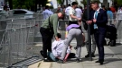
DEVELOPING Slovakia's populist prime minister shot in assassination attempt, shocking Europe before elections
The Slovak defence minister says doctors are fighting for the life of the country's prime minister, who was shot multiple times after a political event Wednesday afternoon.
Transport Canada's UFO 'lead' planned to meet with U.S. intel officials, called info requests a 'wild goose chase'
Canada's transportation department had a UFO 'lead' who tried to 'quell' media interest and planned to meet with U.S. intelligence officials.
'Very expensive lunch': Sask. driver handed a cell phone ticket for using points app in McDonald's drive-thru
A warning from a Saskatoon driver about using your fast-food app while in the drive-thru line — a trip to get some free lunch cost him a lot more than he bargained for.
'The Fly' has become notorious in France after a brazen escape. What's his criminal history?
A prisoner nicknamed “The Fly” has become notorious in France overnight after a daring and bloody escape from a prison convoy in Normandy that left two guards dead.
BREAKING
BREAKING Ontario's 'Crypto King' Aiden Pleterski arrested
Aiden Pleterski, the self-proclaimed 'crypto king' from Whitby, Ont., has been arrested in Durham Region after allegedly running a Ponzi scheme worth more than $40 million.
BREAKING
BREAKING Barge hits a bridge in Texas, damaging the structure and causing an oil spill
A barge slammed into a bridge pillar in Galveston, Texas, on Wednesday, spilling oil into surrounding waters and closing the only road to a smaller and separate island that is home to a university, officials said. There were no immediate reports of injuries.
Person responsible for 1996 drugging of 'Titanic' crew likely not a local: Halifax police
Halifax Regional Police believe a non-resident could be responsible for the infamous drugging of numerous crew members of the 'Titanic' movie with a hallucinogenic in 1996.
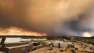
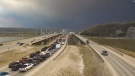
Latest updates on the biggest wildfires burning in Canada
Thousands of people in Western Canada remain displaced from their homes as wildfires threaten their communities, triggering evacuation orders and alerts.
OPINION
OPINION If you think you can’t focus for long, you’re right: Sandee LaMotte
Regaining your focus requires you to be mindful of how you are using technology -- a daunting task if you consider the average American spends at least 10 hours a day on screens.
Shopping Trends
The Shopping Trends team is independent of the journalists at CTV News. We may earn a commission when you use our links to shop. Read about us.


Calgary
-
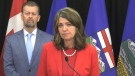
Danielle Smith reacts to Calgary council’s vote to pass blanket rezoning
Alberta Premier Danielle Smith says she remains "concerned" after Calgary councillors passed blanket rezoning on Tuesday.
-
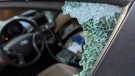
Vehicle with guns inside ditched in Mayland Heights, Calgary police investigating
Calgary police are working to identify two men who are believed to have information about a vehicle recovered from the community of Mayland Heights last year.
-
Calgary's chance of flooding is 'normal' – here's what that means
Though Calgarians have been warned about the potential of drought this summer, it's now flood season in Calgary.
Lethbridge
-

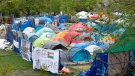
Lethbridge calls first year of encampment strategy a success
While they may not be noticeable to residents, the City of Lethbridge is making a few changes to its encampment strategy to help connect the city’s vulnerable population with services and support.
-
Hundreds of job seekers attend Lethbridge job fair
A job fair saw hundreds of prospective hiring candidates meet with employers in Lethbridge on Tuesday.
-
Deadly southern Alberta highway crash kills two people
Two people were killed and another was seriously injured in a crash in southern Alberta on Sunday.
Saskatoon
-

'Very expensive lunch': Sask. driver handed a cell phone ticket for using points app in McDonald's drive-thru
A warning from a Saskatoon driver about using your fast-food app while in the drive-thru line — a trip to get some free lunch cost him a lot more than he bargained for.
-
As Sask. teachers vote on new sanctions mandate, education minister says bargaining is restarting
Negotiations between the provincial government and Saskatchewan Teachers’ Federation (STF) will be restarting on Wednesday, according to the province’s education minister.
-
Sask. singer Rebecca Strong wins $1M Canada’s Got Talent final
Rebecca Strong is Saskatchewan’s newest millionaire after winning the grand prize on Canada’s Got Talent.
Regina
-

As Sask. teachers vote on new sanctions mandate, education minister says bargaining is restarting
Negotiations between the provincial government and Saskatchewan Teachers’ Federation (STF) will be restarting on Wednesday, according to the province’s education minister.
-
Regina police lay gun charges on man found cycling, blaring loud music
A 28-year-old man found cycling and blaring loud music in the middle of the night on a Regina street is facing multiple firearms related charges after being apprehended by police.
-
No injuries reported in 2 overnight Regina house fires
No one was injured in two overnight house fires in Regina that left at least three people displaced.
Vancouver
-

BC Ferries adds summer sailings, removes fuel charge after 'frustrating' 2023 season
BC Ferries will add 350 more sailings to its schedule this summer and remove its fuel surcharge as the ferry operator looks to avoid a repeat of last summer's travel frustrations caused by mechanical problems and staff shortages.
-
Caught on camera: Suspect spits at McDonald's drive-thru employee
Police in Coquitlam are hoping to identify a suspect they say spat at a McDonald's employee through a drive-thru window earlier this month.
-
BC United explores common ground and potential deal with surging BC Conservatives
At a news conference about after-school care Tuesday, Premier David Eby seemed preoccupied with the BC Conservatives and its leader John Rustad.
Vancouver Island
-
BC Ferries adds summer sailings, removes fuel charge after 'frustrating' 2023 season
BC Ferries will add 350 more sailings to its schedule this summer and remove its fuel surcharge as the ferry operator looks to avoid a repeat of last summer's travel frustrations caused by mechanical problems and staff shortages.
-
BC United explores common ground and potential deal with surging BC Conservatives
At a news conference about after-school care Tuesday, Premier David Eby seemed preoccupied with the BC Conservatives and its leader John Rustad.
-
B.C. man looks to buy bigger house, do more cooking after $1M Lotto 6/49 win
A Metro Vancouver man says he plans to do more cooking – and buy a bigger home to do it in – after winning $1 million on a Lotto 6/49 draw.
Toronto
-
 BREAKING
BREAKING Ontario's 'Crypto King' Aiden Pleterski arrested
Aiden Pleterski, the self-proclaimed 'crypto king' from Whitby, Ont., has been arrested in Durham Region after allegedly running a Ponzi scheme worth more than $40 million.
-
Video shows smash-and-grab robbery at Mississauga mall as police announce arrests
Three suspects are facing charges in connection with jewelry store robberies at two Mississauga malls last week, including one that was captured on video, Peel Regional Police say.
-
'Not a scarient': New COVID-19 subvariant dominant in Canada
A new COVID-19 subvariant is dominant in Canada, representing just over 30 per cent of cases in the country, but infectious disease experts say there’s no sign it’ll evolve into a summer 'scarient.'
Montreal
-
Quebec court rejects McGill injunction request to remove encampment
A Quebec judge has rejected McGill University's request for an injunction to remove the pro-Palestinian encampment on the university's campus in downtown Montreal.
-
Man arrested 10 years after Longueuil bike path murder
A 35-year-old man has been arrested in connection with a decade-old murder case.
-
Montreal airport wants injunction against Saint-Hubert competitor over name change
Aéroports de Montréal (ADM), which operates Montréal-Trudeau International Airport, is suing its Saint-Hubert competitor, claiming that its rebranding will confuse travellers.
Atlantic
-

Man charged for N.S. car crash that killed 3 people
A 25-year-old man is facing multiple dangerous driving charges in connection to a vehicle crash that killed two adults and an infant on a Nova Scotia highway last October.
-
'Sudden death' draws large police presence to Middle Sackville, N.S., neighbourhood
A large police presence in Middle Sackville, N.S., Tuesday night was the result of a sudden death, according to Nova Scotia RCMP.
-
Person responsible for 1996 drugging of 'Titanic' crew likely not a local: Halifax police
Halifax Regional Police believe a non-resident could be responsible for the infamous drugging of numerous crew members of the 'Titanic' movie with a hallucinogenic in 1996.
Winnipeg
-

68 dogs seized from Winnipeg home: Humane Society
The Winnipeg Humane Society (WHS) says more than 60 dogs have been seized from a home Wednesday.
-
Neighbour testifies about late night encounter with admitted serial killer Jeremy Skibicki
Neighbours of admitted serial killer Jeremy Skibicki testified about the man’s late night outings when he was “just getting rid of garbage” – later determined to be the remains of one of his four victims.
-
Arrest made after Winnipeg grocery store employees assaulted with brass knuckles: WPS
Police say a teenager is facing charges after three employees at a Winnipeg grocery store were assaulted with brass knuckles.
Ottawa
-

Small earthquake rattles eastern Ontario, western Quebec
A 3.2 magnitude earthquake was felt east of Ottawa on Wednesday morning.
-
Para Transpo driver facing sexual assault charges
A Para Transpo driver is facing charges following an investigation into an alleged sexual assault of a passenger on a transit vehicle last winter.
-
Body of missing Carleton Place man found in Mississippi River
A 52-year-old man from Carleton Place, Ont. reported missing four months ago has been located deceased, according to police.
Northern Ontario
-
'Very expensive lunch': Sask. driver handed a cell phone ticket for using points app in McDonald's drive-thru
A warning from a Saskatoon driver about using your fast-food app while in the drive-thru line — a trip to get some free lunch cost him a lot more than he bargained for.
-
Tazed and bitten in the face: Sudbury police dealt with some wild cases last month
The monthly police services board in Greater Sudbury gives the public insight into the day-to-day operations of police, including some of the cases they deal with far from the spotlight.
-
Human remains identified as missing northeastern Ont. man
The search for a missing northeastern Ontario man has come to a tragic end after his remains were identified.
Barrie
-

Barrie's Southshore Community Centre to be renamed
The Southshore Community Centre in Barrie will be given a new name to honour a retired Brigadier General who served over half a century in the Canadian Armed Forces.
-
Pickup truck crashes through guardrail along Highway 11 in Muskoka
Emergency crews were called to remove a pickup truck from a ditch along Highway 11 after a collision on Wednesday in Muskoka.
-
Man accused of driving erratically while impaired in parking lot arrested
A man accused of driving erratically in an Owen Sound parking lot while impaired was arrested and charged.
Kitchener
-

Immigration Minister Marc Miller weighs in on local international student enrollment
Marc Miller dropped by the CTV Kitchener studio to answer some questions, taking the time to comment on international student enrollment in post secondary schools.
-
BREAKING
BREAKING Ontario's 'Crypto King' Aiden Pleterski arrested
Aiden Pleterski, the self-proclaimed 'crypto king' from Whitby, Ont., has been arrested in Durham Region after allegedly running a Ponzi scheme worth more than $40 million.
-
Man arrested after hit-and-run involving pregnant woman: Guelph police
A Kitchener man has been arrested after police say he was involved in a hit-and-run crash that sent a pregnant woman to hospital.
London
-

Elgin County OPP confirm death of Tanya Wiebe 'a homicide'
More than three months after her death, OPP in Elgin County are confirming the death of Tanya Wiebe was the result of a murder-suicide.
-
'Smoke in the electrical room' closes down London City Hall
London City Hall has been evacuated and will be closed for the remainder of the day after smoke was discovered in the electrical room on Wednesday morning.
-
Listowel, Ont. strongman pushing car 21 kilometers for charity
Cole Brubacher will be putting a few kilometres on his Mazda this weekend — but not how you might imagine.
Windsor
-
Avoid keeping original copies of ownership and insurance documents in vehicle: police
The Windsor police auto theft unit is asking the public to avoid keeping the original copies of ownership and insurance documents in their vehicles.
-
Sinkhole causes detours in Sandwich
Transit Windsor says a sinkhole is causing detours in Sandwich Town.
-
Arrest warrant issued for break-in suspect caught on camera
Windsor police have issued an arrest warrant for a suspect wanted after a home break-in was caught on a security camera.


