Josh Classen's forecast: Snow today and then even colder tomorrow

We haven't hit the bottom of the cold spell yet. That'll come Thursday/Friday/Saturday.
It'll be the coldest first week of Decemer since... 2013. (Probably not as long ago as you might've guessed.)
We'll get to that in a moment, first let's talk snow. Some flurries will move through into the Edmonton area this morning and then intensify a bit this afternoon.
By the time it moves out of the area this evening, we'll probably have 2 to 5 cm of fresh snow on the ground (and it looks like 5 cm is more likely than 2 cm).
With most of that snow coming this afternoon, the evening commute will be affected far more than the morning commute.
Areas north of Highway 16 will get progressively lower amounts the further north you are with the Grande Prairie, Slave Lake Cold Lake areas only getting a dusting to 2 cm.
It's areas near Red Deer and east and south of that area that could get the most snow (potentially 5 to 10 cm).
Gusty wind in east-central Alberta will also create significantly reduced visibility in blowing snow later this afternoon.
Wind speeds in the Edmonton region should be around 15-20 km/h.
So, that's not TERRIBLY strong. But, it's enough to create a bit of blowing snow in exposed areas and along outlying roads and highways.
Temperatures should hold fairly steady around -16 C much of the day and that'll mean wind chills around -23 C for most of today.
Wind eases overnight tonight and I have the city dropping to around -21 C Thursday morning.
IF skies clear a bit sooner than I'm expecting, we could be a couple degrees colder.
Sunny with a few clouds and a high near -19 C Thursday afternoon (with almost no wind).
The coldest temperatures come Friday morning and Saturday morning.
There's a real shot at hitting -30 C on Friday morning. I currently have a morning low of -29 C.
Saturday morning should also be in the -25 C to -30 C range (but, probably a degree or two "warmer" than Friday morning).
Temperatures are expected to stay in the -20s ALL DAY Friday.
Saturday afternoon climbs to the mid minus teens.
AND...the arctic air BRIEFLY shifts a bit late Saturday/early Sunday. So, I'm thinking we'll get close to -10 C (maybe even a single-digit temperature) on Sunday.
We'll probably return to highs in the minus teens for Monday/Tuesday.
Looking LONG range - there's a chance we get into some milder air for the middle to the end of next week. But, we'll probably still remain colder than average (average highs next week are in the -4 C range).
Back to that "coldest since" issue:
Three of the past five years have had really mild starts to December.
This year, we'll have an average high around -14 C from Dec. 1 to 7.
That's the coldest since the avg high of -14 C in 2013.
Here's more:
***We'll probably have a high below -20 C in the first week of December.
That hasn't happened since 2013 (-21 C on Dec. 5).
***Edmonton will drop below -25 C in the first week of December.
That hasn't happened since 2013 (it happened FOUR times that year).
***Edmonton might hit -30 C in the first week of December this year.
That hasn't happened since (you guessed it) 2013. We hit -31 C twice that year.
So...you might be wondering, "what happened in the rest of December 2013?"
History doesn't often repeat itself. BUT...it does give us a guide.
AND...that guide shows us we probably won't stay cold for the entire month.
Edmonton had a high above zero by Dec. 15, 2013. We ended up with eight days above 0 C by the end of the month.
However, the month as a whole ended up about four degrees colder than average.
Here's the forecast for Edmonton and area:
Today - Cloudy with periods of snow. 2 to 5 cm.
Wind: E 15-20 km/h
Temperatures steady near -16 ***wind chill near -23 for most of the day
Tonight - Snow ending this evening. Partly cloudy overnight.
9pm: -18
Thursday - Sunny with a few clouds. Light wind.
Morning Low: -21
Afternoon High: -19
Friday - Sunny with a few clouds.
Morning Low: -29
Afternoon High: -21
Saturday - Mix of sun & cloud.
Morning Low: -27
Afternoon High: -15
Sunday - Mix of sun & cloud.
Morning Low: -16
Afternoon High: -10
Monday - Mostly cloudy. 30% chance of flurries.
Morning Low: -16
Afternoon High: -13
Edmonton Top Stories
-
-
-
-
-
-
 WEATHER
WEATHER Josh Classen's forecast: Warmest days of the year (so far)
-
-
 BREAKING
BREAKING Sheldon Keefe out as head coach of Toronto Maple Leafs


CTVNews.ca Top Stories

Why these immigrants to Canada say they're thinking about leaving, or have already moved on
For some immigrants, their dreams of permanently settling in Canada have taken an unexpected twist.
DEVELOPING
DEVELOPING Live updates from the Trump hush money trial: Stormy Daniels, bookkeeper testify
Adult film star Stormy Daniels is on the stand a second time Thursday as former U.S. president Donald Trump’s hush money case continues in Manhattan. Follow live updates here.
Ontario family receives massive hospital bill as part of LTC law, refuses to pay
A southwestern Ontario woman has received an $8,400 bill from a hospital in Windsor, Ont., after she refused to put her mother in a nursing home she hated -- and she says she has no intention of paying it.
Here are the ultraprocessed foods you most need to avoid, according to a 30-year study
Studies have shown that ultraprocessed foods can have a detrimental impact on health. But 30 years of research show they don’t all have the same impact.
Ontario man frustrated after $3,500 paving job leaves driveway in shambles
An Ontario man considering having his driveway paved received a quote from a company for $7,000, but then, another paver in the neighbourhood knocked on his door and offered half that rate.
BREAKING
BREAKING Sheldon Keefe out as head coach of Toronto Maple Leafs
The Toronto Maple Leafs have fired head coach Sheldon Keefe. The team made the announcement Thursday after the Original Six franchise lost to the Boston Bruins in seven games in the first round of the Stanley Cup playoffs.
Boeing 737 catches fire and skids off the runway at a Senegal airport, injuring 10 people
A Boeing 737-300 plane carrying 85 people skidded off a runway at the airport in Dakar, Senegal's capital, injuring 10 people, according to the transport minister, an airline safety group and footage from a passenger that showed the aircraft on fire.
Breast cancer screening should start at age 40, Canadian Cancer Society says
The Canadian Cancer Society says all provinces and territories should lower the starting age for breast cancer screening to 40.
Man accused of killing two children at Quebec daycare to stand trial in April 2025
The man accused of murdering two children and injuring six others after a city bus crashed into a Montreal-area daycare is scheduled to stand trial over five weeks beginning in April 2025.
Shopping Trends
The Shopping Trends team is independent of the journalists at CTV News. We may earn a commission when you use our links to shop. Read about us.


Calgary
-

Calgary police release sketch of man found dead near Bow River
Calgary police have released the composite sketch of a man found dead near the Bow River in March in hopes it will assist the public in identifying him.
-
WHL 'exceptional status' player Landon Dupont selected first overall
The Western Hockey League (WHL) draft is underway and an "exceptional" 14-year-old player has been selected first overall.
-
Alberta man to be sentenced for 2022 impaired driving crash that killed Calgary couple
An Alberta man who admitted to being under the influence of fentanyl and pleaded guilty to dangerous driving causing the 2022 deaths of Macy Boyce and Ethan Halford is scheduled to receive his sentence Thursday.
Lethbridge
-
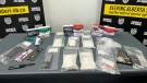
Four arrested in drug bust in Medicine Hat, Alta.
Four people are facing a series of charges following a drug bust in Medicine Hat last month.
-
Lethbridge police seek suspects after $4,000 in sunglasses stolen
Lethbridge police are looking for a pair of suspects they say took $4,000 worth of sunglasses from a local business.
-
Brooks Bandits getting ready for BCHL Alberta division finals
It took seven games, but the Brooks Bandits were able to knock off the Okotoks Oilers in the BCHL Alberta division semi-finals. After a hard-fought series, the Bandits are feeling battle-tested.
Saskatoon
-

'Hours, not days': Concerns grow around accuracy of THC roadside testing in Sask.
Concern is growing around roadside THC testing, cannabis use and driving in Saskatchewan.
-
Sask. education minister says teachers' vote results could lengthen school year
Saskatchewan's education minister is being accused of trying to influence a teachers vote after saying he's not ruling out extending the school year should educators reject his offer and take job action.
-
Sask. barista prepares to roast competitors at national coffee competition
A competitor from Saskatoon is heading to Vancouver for a competition that promises to be quite the grind.
Regina
-

Sask. education minister says teachers' vote results could lengthen school year
Saskatchewan's education minister is being accused of trying to influence a teachers vote after saying he's not ruling out extending the school year should educators reject his offer and take job action.
-
Regina police hope new biometric monitoring system will save lives in detention facility
The Regina Police Service says it is the first in Saskatchewan and possibly Canada to implement new technology in its detention facility that will offer real-time monitoring of detainees’ vital health metrics.
-
Here's a complete timeline of the Saskatchewan teachers labour dispute
The dispute between Saskatchewan educators and the province is rapidly approaching one year in length. It's a fight that's seen a war of words waged over social media, teachers battling extreme cold on the picket line and massive disruptions for the province's student population.
Vancouver
-
B.C. wildfires likely to spread with weekend temperatures expected to soar, province says
Wildfire and emergency management officials in British Columbia are urging residents to be prepared for increased fire activity as temperatures are expected to soar above 30 C in parts of the province this weekend.
-
Rivers recede as B.C. faces prospect of 'unfamiliar territory' for drought
Parts of British Columbia will likely enter "unfamiliar territory" with drought if they see another hot, dry summer, says the head of the province's River Forecast Centre.
-
Galápagos Islands mail mystery solved after phone call from stranger
When Sherry Kirkvold played the voicemail message from a stranger – which began with, “Hi. This is kind of a random message for you. This one’s been a while.” – she couldn’t have been more surprised.
Vancouver Island
-
B.C. wildfires likely to spread with weekend temperatures expected to soar, province says
Wildfire and emergency management officials in British Columbia are urging residents to be prepared for increased fire activity as temperatures are expected to soar above 30 C in parts of the province this weekend.
-
Galápagos Islands mail mystery solved after phone call from stranger
When Sherry Kirkvold played the voicemail message from a stranger – which began with, “Hi. This is kind of a random message for you. This one’s been a while.” – she couldn’t have been more surprised.
-
'Sophisticated' cyberattacks detected on B.C. government networks, premier says
There has been a "sophisticated" cybersecurity breach detected on B.C. government networks, Premier David Eby confirmed Wednesday evening.
Toronto
-
BREAKING
BREAKING Sheldon Keefe out as head coach of Toronto Maple Leafs
The Toronto Maple Leafs have fired head coach Sheldon Keefe. The team made the announcement Thursday after the Original Six franchise lost to the Boston Bruins in seven games in the first round of the Stanley Cup playoffs.
-
'Completely unworthy of belief': Toronto cop who stole credit cards, luxury watch from the dead found guilty
A veteran Toronto police officer was found guilty this week of stealing credit cards and a $6,500 watch from the deceased individuals he was tasked with investigating.
-
Ontario family receives massive hospital bill as part of LTC law, refuses to pay
A southwestern Ontario woman has received an $8,400 bill from a hospital in Windsor, Ont., after she refused to put her mother in a nursing home she hated -- and she says she has no intention of paying it.
Montreal
-

Cyclist strikes child crossing the street to catch school bus in the Plateau
A video circulating on social media of a young girl being hit by a bike has some calling for better safety and more caution when designing bike lanes in the city.
-
Man accused of killing two children at Quebec daycare to stand trial in April 2025
The man accused of murdering two children and injuring six others after a city bus crashed into a Montreal-area daycare is scheduled to stand trial over five weeks beginning in April 2025.
-
Highway 15 collision leaves 1 man dead north of Montreal
An early morning collision on Highway 15 has left one man dead north of Montreal.
Atlantic
-

36-year-old man dead after alleged shooting in North Preston, N.S.
A 36-year-old Westphal, N.S., man is dead after an alleged shooting in North Preston Wednesday night.
-
Trucker's body found in trailer in Newfoundland after failed police search in Ontario
Ontario Provincial Police are facing tough questions about their search for a missing Newfoundland trucker whose rig was found two weeks ago in Ontario, then sent back to Newfoundland, where his body was found Monday in the trailer.
-
Lack of parking, high traffic keeping some Halifax-area residents away from downtown core: study
A lack of parking, high traffic volumes, affordability and construction are the main reasons some Halifax Regional Municipality (HRM) residents are staying away from the city's downtown core, according to a recent study.
Winnipeg
-

Winnipeg trial hears victims' clothing, jewelry found in serial killer's apartment
A Winnipeg trial has heard the belongings of two slain women were found in the apartment of an admitted serial killer.
-
Last-ditch effort to keep St. Boniface pool open voted down by city committee
A last-ditch effort to keep a St. Boniface pool open for another year may have gone down the drain for good.
-
Fire forcing Manitoba high school students to finish year off-site
A major fire is forcing students at a southern Manitoba high school to finish the school year off-site.
Ottawa
-
$1 million investment for cleaner, healthier air, energy savings at CHEO
The federal government says the Children's Hospital of Eastern Ontario's (CHEO) will have major updates, resulting in healthier and cleaner air, and energy savings.
-
This Ottawa ward has the most complaints about rats so far in 2024
Bylaw and Regulatory Services received 119 service requests for rats on private property so far in 2024, after receiving 779 service requests in 2023.
-
Watch out for red light and photo radar cameras on King Edward Avenue
Motorists will want to watch out for cameras on a one-kilometre stretch of King Edward Avenue, where photo radar and red light cameras have caught thousands of drivers so far this year.
Northern Ontario
-
 BREAKING
BREAKING Skeletal remains found in Sudbury identified man missing since 2013
Sudbury police say they have identified the skeletal remains found last week in a wood area of Chelmsford and that no foul play was involved.
-
Here are the ultraprocessed foods you most need to avoid, according to a 30-year study
Studies have shown that ultraprocessed foods can have a detrimental impact on health. But 30 years of research show they don’t all have the same impact.
-
BREAKING
BREAKING Sheldon Keefe out as head coach of Toronto Maple Leafs
The Toronto Maple Leafs have fired head coach Sheldon Keefe. The team made the announcement Thursday after the Original Six franchise lost to the Boston Bruins in seven games in the first round of the Stanley Cup playoffs.
Barrie
-

Proposed waterfront development gets thumbs up from city councillors
Barrie city councillors granted preliminary approval to a proposed waterfront development intended to accommodate the Sea Cadets and provide benefits for sports organizations, sparking mixed reactions.
-
Man accused in Elnaz Hajtamiri murder case charged with assaulting inmate
Mohamad Lilo, the 36-year-old Montreal-area man, accused in the murder and kidnapping of his former girlfriend, Elnaz Hajtamiri, has now been charged with assaulting an inmate at Central North Correctional Centre.
-
Barrie mayor pushing for more speed cameras
Barrie's mayor is pushing for more photo radar cameras to help curb speeding in the City.
Kitchener
-

Listowel, Ont. football player drafted, despite only three years of experience
A Listowel, Ont. man, drafted by the Hamilton Tigercats last week, is also getting looks from the NFL, despite only playing 27 games of football in his life.
-
Long-time CKCO personality, Janine Grespan, dies at 63
A broadcaster familiar to many CTV News watchers has died at the age of 63.
-
Cambridge withdraws encampment eviction notices
A resolution has been reached over evictions at a Cambridge, Ont. encampment.
London
-

Josh Morgan announces separation from his wife
London Mayor Josh Morgan has announced the separation between him and his wife Melanie.
-
OPP searching for three masked suspects after stabbing in Norwich
One person suffered non life-threatening injuries following a stabbing Wednesday night in Norwich.
-
Listowel, Ont. football player drafted, despite only three years of experience
A Listowel, Ont. man, drafted by the Hamilton Tigercats last week, is also getting looks from the NFL, despite only playing 27 games of football in his life.
Windsor
-

Four Windsor-Essex men arrested in underage prostitution operation
Windsor police and OPP say they have arrested four men during an undercover operation targeting men seeking sex with underage girls.
-
Ontario family receives massive hospital bill as part of LTC law, refuses to pay
A southwestern Ontario woman has received an $8,400 bill from a hospital in Windsor, Ont., after she refused to put her mother in a nursing home she hated -- and she says she has no intention of paying it.
-
Students launch UWindsor 'Liberation Zone'
University of Windsor students are launching a “Liberation Zone” on campus in solidarity with the Popular University for Gaza and striking students around the world.


