We've had some showers S & SW of Edmonton this morning.
But there's more snow than rain in the weekend forecast.
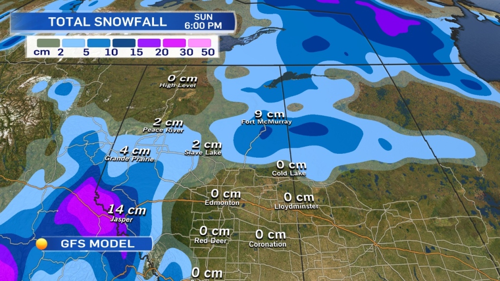
The attached graphic is the GFS model's Total Snowfall Accumulation for today through to 6pm Sunday.
5-10cm of snow is possible in parts of the Peace Country (where there already was some snow Thursday).
The Fort McMurray region could get 5-10cm as well.
In the mountains, 10-15cm is likely...especially at higher elevations.
There IS a risk of snow for the Capital Region as well.
Any precipitation late Saturday should come down as rain.
BUT... we'll get some cooling on Sunday. By Sunday night, precipitation is likely to fall as either snow or a rain/snow mix.
There's still no guarantee that we get ANY precipitation late Sunday.
But if we do, it's probably white.
The bigger story for Edmonton will be the dramatic drop in temperature.
By Monday...we'll be almost 20 degrees COLDER than last Monday.
Daytime highs stay in the 0 to 5 range through the first half of the week.
By the end of the week, there's a SLIGHT warming & we may see daytime highs climb to 7 or 8.
Here's the Edmonton forecast:
Today - Sunny with a few clouds.
Wind: W 20 this morning. W 30 gusting to 50 this afternoon.
High: 11
Tonight - A few clouds.
Low: 0
Saturday - Mostly cloudy. 40% chance of a late-day shower.
High: 8
Sunday - Mostly cloudy.
30% chance of wet flurries in the evening.
Morning Low: 0
Afternoon High: 5
Monday - Mix of sun & cloud.
Morning Low: -2
Afternoon High: 3
Tuesday - Mix of sun & cloud.
Morning Low: -3
Afternoon High: 4
Wednesday - Mostly cloudy. 20% chance of flurries.
Morning Low: -3
Afternoon High: 3
Advertisement
AND SO IT BEGINS... - October 24, 2014
CTV Edmonton
Published Friday, October 24, 2014 7:50AM MDT
Published Friday, October 24, 2014 7:50AM MDT
