Warm air is already pushing in from the south this morning.
The question remains: How far north will it reach?
Edmonton will be very close to the northern edge of double-digit temperatures.
However, I think we may "only" end up in the 7 to 9 degree range.
If the wind swings to the south, we might hit 10. If it stays ESE, expect to be closer to 7.
Speaking of the wind, it'll be a lot calmer than yesterday. Should be 10-20km/h most of the day instead of 30 gusting to 50.
More cloud than sun today, but we should stay dry for most of the day & evening.
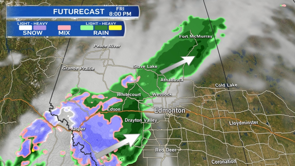
As you can see in the attached Futurecast map, areas W & N of the Capital Region will get some showers this evening.
There's a slight risk of a few scattered showers in parts of the area around 9/10pm & overnight.
We'll be in the 4-8 degree range this weekend.
If you're heading to the Eskimos game Saturday, expect a kickoff temperature of about 6 degrees & 10-15km/h wind.
Don't forget, it's time change weekend.
We FALL BACK an hour early Sunday morning (Nov 2)
Clocks go from 2am to 1am on Sunday morning as we go from Mountain Daylight Time to Mountain Standard Time.
After that extra hour of sleep...we get some clearing & a mild day Sunday.
Here's the Edmonton forecast:
Today - Mostly cloudy.
High: 8
Tonight - Cloudy. 30% chance of a shower late this evening and/or overnight.
Low: 0
Saturday - Cloudy with sunny breaks.
High: 6
TIME CHANGE - Clocks go back 1hr
Sunday - Partly cloudy.
Morning Low: -1
Afternoon High: 6
Monday - Partly cloudy.
Morning Low: -1
Afternoon High: 6
Tuesday - Increasing cloud. 40% chance of showers.
Morning Low: 0
Afternoon High: 7
Wednesday - Mix of sun & cloud.
Morning Low: -1
Afternoon High: 4
Advertisement
CALMER & WARMER - October 31, 2014
CTV Edmonton
Published Friday, October 31, 2014 8:29AM MDT
Published Friday, October 31, 2014 8:29AM MDT
