A hot month of June will end with another hot & stormy day.
June 2016 will end up about 2 degrees warmer than the 30-yr average for both highs & lows.
The long-term average high is 21.0 & the low is 9.9 In 2016...we have an average high of 23.3 going into today (which may push us a tenth of a degree higher) The average low this month has been 11.3 degrees.
As we've seen over the past few days, comparing precipitation stats in the thunderstorm season can miss the point completely.
Edmonton has had close to 50mm of rain in some eastern neighbourhoods & 0mm in parts of west Edmonton over the past 2 days.
So...was it a wetter than average month? For some areas...yes. For some parts of the city...no.
Ok...enough with looking back...let's look ahead to today & the long weekend.
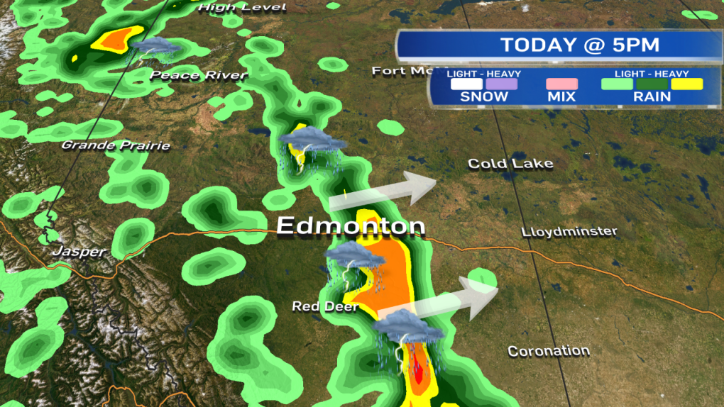
There's a very favourable setup for thunderstorms again today. Storms will start in the foothills and track east through the day.
They should be in or near the Edmonton area by this afternoon & off to the east of the city by 9pm'ish (roughly).
We're anticipating a long line of storms from north to south with hail, heavy downpours & very strong wind gusts being the main threats.
Further south, (south of Red Deer) the storms may take longer to initiate & have the potential to produce LARGE hail.
You may be hearing/reading about a tornado risk from different sources today.
As I mentioned yesterday, if there's going to be any development...it's likely in the Olds-Brooks area & then east towards Youngstown.
HOWEVER...the folks as the Prairie & Arctic Storm Prediction Centre point out.....IF anything develops, it'll likely be short-lived.
So...that's not going to be a primary threat today. The MAIN risk for all areas will be hail, heavy downpours & wind.
In and around the Capital Region...most of the long weekend looks warm & fairly sunny.
Temperatures should get into the mid 20s Fri/Sat/Sun.
There IS an chance of some late-day showers or thunderstorms in the area Friday.
But...most of the daytime highs should be dry & Sat/Sun look like beautiful days as well.
Here's the Edmonton forecast:
Today - Increasing cloud. 80% chance of an afternoon and/or evening thunderstorm.
High: 26
Tonight - 80% chance of an evening thunderstorm. Clearing overnight.
Evening: 18
Friday - Partly cloudy.
Morning Low: 14
Afternoon High: 25
30% chance of an isolated shower or thunderstorm Friday night.
Saturday - Sunny with a few clouds.
Morning Low: 15
Afternoon High: 24
Sunday - Partly cloudy.
Morning Low: 13
Afternoon High: 24
Monday - Mix of sun & cloud.
Morning Low: 13
Afternoon High: 22
Tuesday - Mix of sun & cloud.
Morning Low: 13
Afternoon High: 21
Advertisement
HOT & STORMY (AGAIN) - June 30, 2016
CTV Edmonton
Published Thursday, June 30, 2016 9:02AM MDT
Published Thursday, June 30, 2016 9:02AM MDT
