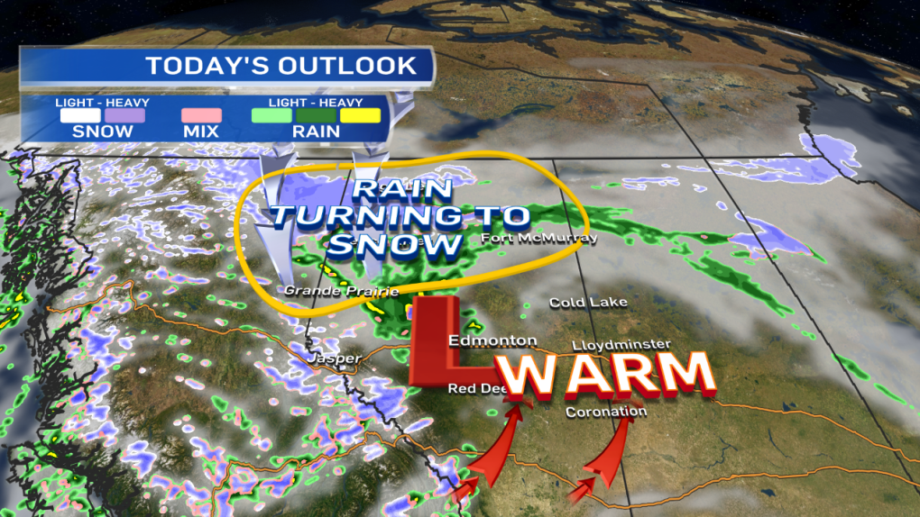
Temperatures are expected to climb into the mid to high teens in Central & North-Central Alberta today.
We're getting a feed of warm air ahead of a low pressure system that's generating rain in NW Alberta this morning.
However, a collapsing upper ridge means some colder air is dropping in aloft.
That mid-level cooling may initially generate enough instability to kick off 1 or 2 thunderstorms in Central Alberta this afternoon.
However, as the cooling continues...it'll cause the precip to flip from rain to snow.
Parts of Northern Alberta are still looking at a risk of heavy snow. 5-10cm is possible from the Peace Country east towards Bonnyville.
Edmonton's in an interesting spot.
There's not much agreement in precip type or amount. GFS is playing up the chance of rain later today, while GEM-LAM has virtually no rain.
Both models put a couple centimetres of snow on Edmonton tomorrow, but the RPM model is holding that off until the afternoon.
Given the uncertainty, I'll go with a good chance of a few showers late this afternoon...a slight risk of precipitation overnight & a high risk of snow Wednesday.
How much accumulation?
Spring snow has so many variables that play into accumulation & the Capital Region is a large enough geograhic region to produce wildly-different snow totals.
I think we're probably looking at a situation where parts of the area will only get 1 or 2cm of accumulation & other spots see as much as 8cm.
Blowing snow could be a problem for travel.
Wind gusts in the 40-60km/h range are expected Wednesday morning & early afternoon.
Cooler weather settles in for a few days with highs in the 3 to 8 range for Wed/Thu/Fri/Sat/Sun.
Here's the Edmonton forecast:
Today - Increasing cloud. 70% chance of showers.
Slight risk of an isolated thunderstorm in the area.
High: 16
Tonight - Mostly cloudy. 30% chance of a rain/snow mix.
Low: 2
Wednesday - Cloudy. 70% chance of snow.
Wind: NW 30 gusting to 50 in the morning, easing later in the day.
2-8cm possible.
High: 4
Thursday - Mostly cloudy. 40% chance of an afternoon shower.
Morning Low: -3
Afternoon High: 6
Friday - Partly cloudy.
Morning Low: -2
Afternoon High: 8
Saturday - Mostly cloudy. 30% chance of light rain turning to snow in the evening.
Morning Low: -2
Afternoon High: 8
Sunday - Mostly cloudy.
Morning Low: -4
Afternoon High: 3
Advertisement
WARM... BUT NOT FOR LONG - March 31, 2015
CTV Edmonton
Published Tuesday, March 31, 2015 8:21AM MDT
Published Tuesday, March 31, 2015 8:21AM MDT
