Thunderstorms pass through Edmonton, Red Deer and west-central Alberta
 Lightning seen in Beaver County north of Tofield, Alta., on June 11, 2024. (Submitted: Brenda Carlson)
It was a beautiful spring day in Edmonton, but it's ending on a stormy note.
Severe thunderstorms that developed over the city late Tuesday afternoon and brought wind, rain and lightning have moved off to the east-northeast, with the threat of severe storms ending for the time being.
As of 7 p.m. Tuesday, Environment and Climate Change Canada (ECCC) had ended the severe thunderstorm warning for Edmonton and area and kept the city, St. Albert and Sherwood Park under a thunderstorm watch alert.
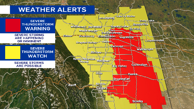
ECCC had issued a severe thunderstorm warning at 5:15 p.m. for Edmonton and area as well as regions of the city south along Highway 2 through Red Deer and Calgary.
Earlier severe thunderstorm warnings for areas near Red Deer, Olds, Grande Cache, Botten, Amundson and Alder Flats have also ended.
The Edmonton region will continue to see rain and a few non-severe thundershowers early in the evening. The potential exists for a few more thunderstorms to redevelop mid-evening.
Cloudy, wet, windy and cool conditions will take over on Wednesday with gusts in the 40-50 km/h range through most of the day in Edmonton.
Rain may be in the area for much of the day, but the morning will likely be wetter than the afternoon.
A severe thunderstorm 'warning' means the severe storms are occurring or imminent, while a 'watch' means potential for severe weather.
 A severe thunderstorm warning on June 11, 2024, in Edmonton and area ended early in the evening as storms moved east-northeast of the city. (Josh Classen/CTV News Edmonton)
High over 20 C, clouds develop in afternoon, thunderstorms
For the second consecutive day, we got into the low 20s in Edmonton.
Sunshine and light wind early in the day gave way to increasing afternoon cloud then thunderstorms.
Edmonton's had back-to-back 20-degree days just a few times this spring:
- May 9/10
- May 27/28
- June 1/2
And there are no three or four-days stretches in the 20s.
That trend will continue as cooler air settles in for Wednesday.
The heaviest, steadiest rain will be in east-central/northeast Alberta.
Here's the forecast for Edmonton and area:
Wednesday - Cloudy with periods of light rain.
Wind: WNW 30 gusting to 50 km/h
Morning Low: 11
Afternoon High: 14
Thursday - Cloudy in the morning, clearing in the afternoon.
Morning Low: 9
Afternoon High: 19
Friday - Partly cloudy. 30% chance of an evening shower/thunderstorm.
Morning Low: 11
Afternoon High: 22
Saturday - Mix of sun & cloud. 30% chance of a late-day shower.
Morning Low: 11
Afternoon High: 19
Sunday - Mostly cloudy. 40% chance of showers.
Morning Low: 9
Afternoon High: 16
CTVNews.ca Top Stories

Auto theft probe leads to arrest of 59 suspects, recovery of more than 300 stolen vehicles: Toronto police
Toronto police say 59 suspects are facing a total of 300 charges in connection with an auto theft and re-vinning probe.
Ont. woman posed as registered nurse in Simcoe County for 4 years: OPP
An Ontario woman is facing serious charges after police allege she pretended to be a registered nurse at several Simcoe County facilities, despite being unqualified.
B.C. mayor's 'luxury' trip to Dubai climate conference was against ethics rules: commissioner
New Westminster Mayor Patrick Johnstone's all-expenses-paid trip to Dubai for a climate conference last December violated the city's Code of Conduct for Council Members and the Community Charter, the city's ethics commissioner has ruled.
WATCH 'It's mind-boggling': Drought reveals U.S. town submerged in the 1940s
Hundreds of people are flocking to see a rare site in Pennsylvania: remnants of a historic town that is usually underwater.
Democrats Abroad Canada warns U.S. voters to take action ahead of possible Canada Post strike
Democrats Abroad Canada is warning Americans that a potential postal workers strike this weekend could affect the ability to vote in next week's election.
Caught on camera: Edmonton police run over woman during welfare call
An Edmonton Police Service officer was caught on camera running over a woman with a marked cruiser last month.
Orphaned squirrel who became social media star was euthanized after being seized from New York home
An orphaned squirrel that became a social media star called Peanut was euthanized after state authorities seized the beloved pet during a raid on his caretaker's home, authorities said Friday.
B.C. landlord who evicted longtime tenant, hiked rent and re-listed unit ordered to pay $16K
A landlord from B.C.’s Lower Mainland who evicted a longtime tenant only to rent out the same unit months later for more money has been ordered to compensate him $16,480.
Secret Service report offers new details on failures during Trump assassination attempt
A new Secret Service report into the July assassination attempt against former U.S. president Donald Trump said multiple staffers knew about clear line-of-sight risks but found them 'acceptable' and that farm equipment intended to obstruct the view from the nearby building where the gunman opened fire was never used.


