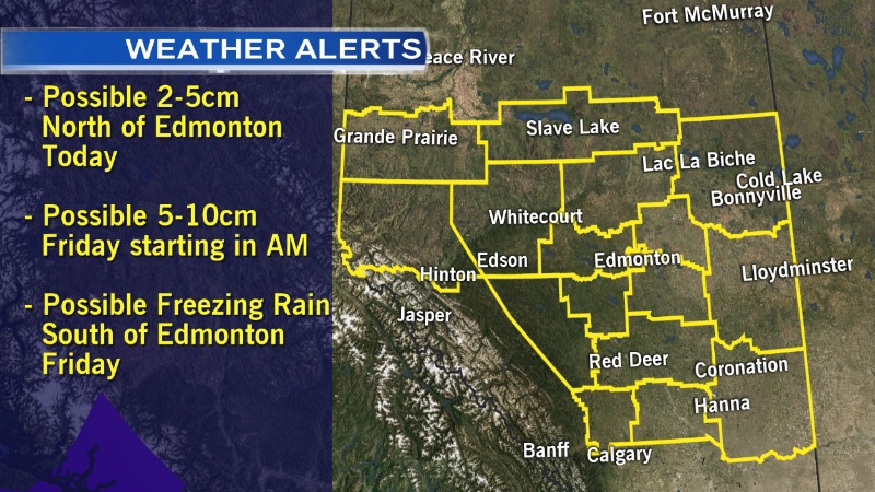
Environment Canada issued a special weather statement for much of central Alberta Thursday, issuing a warning over winter weather expected to round out the week.
In a statement posted online Thursday, Environment Canada said two weather systems are expected to move in after going through British Columbia.
CTV Edmonton meteorologist Cory Edel said the two systems will move in from the Gulf of Alaska.
“Both of these systems contain quite a bit of moisture, creating the potential for some dangerous road conditions throughout the province,” Edel said. “The first of these is already tracking north eastward from across the Rockies.”
Edel said much of the snow and rain snow mix will fall west and north of Edmonton, with some areas expecting about 5 centimetres of precipitation – the end of the first system will pass near Edmonton, and have a 40 percent chance of a rain snow mix late Thursday afternoon and early evening.
That’s just the start – the second system is expected to pass through Edmonton early Friday morning, with precipitation expected at about 4 a.m. Friday.
“Due to the fact that the airmass will be around the freezing mark, we can expect to see a rain snow mix, lasting through the morning commute and turning to on and off snow heading into the evening,” Edel continued.
The storm may impact roadways, with driving conditions in Edmonton and west along the Yellowhead potentially deteriorating quickly, with slick roadways and poor visibility.
Edel said there is a chance some central areas could see about 15 centimetres of snow, although much of it will melt and create slushy conditions.
South of Edmonton, Edel said early morning temperatures are expected to fall below the freezing mark, leading to a risk of freezing rain Friday morning.
“Caution will need to be taken on roads from Edmonton all the way down to Calgary,” Edel said.
All that rain and slush, coupled with cooler temperatures on Saturday could lead to ice forming on roads and sidewalks, and slick driving and walking conditions.
